
Geography of Colorado Springs, Colorado facts for kids

Colorado Springs is a big city in El Paso County, Colorado. It's known for its amazing natural beauty and interesting land. This article will tell you all about the geography of Colorado Springs, like its mountains, rivers, and how people use the land. It's the biggest city in Colorado by size, covering about 195 square miles!
Contents
Where is Colorado Springs?
Colorado Springs is located in a special area near Pikes Peak. It's part of the Front Range, which is a long stretch of land about 40 miles long. The city sits right at the edge of the southern Rocky Mountains.
The land around the city is very diverse. To the north, you'll find the Palmer Divide. To the east are wide plains and grasslands. South of the city, the land becomes more like a high desert, leading towards Pueblo.
The city was first built where two creeks meet: Monument Creek and Fountain Creek. These creeks are part of the larger Arkansas River system. A major highway, Interstate 25, runs through the city. It connects Colorado Springs to other cities like Castle Rock, Denver, Fort Collins, and Pueblo.
Climate and Elevation
Colorado Springs has a semi-arid climate. This means it's pretty dry, getting about 15 to 16 inches of rain each year. The temperatures are usually mild. The land gets even drier as you go south from the city. Colorado Springs is quite high up, sitting at about 6,035 feet above sea level.
What the Land Looks Like
The city was built on a type of rock called Pierre Shale. On the eastern side of the city, you'll find hills made of older sandstone. Some cool sandstone ledges are from the Dakota Formation. In the northern part of the city, there's a lot of pediment rock. The western side has pediment gravels. People have also dug for limestone in the mountains nearby.
Famous Rock Formations
You can see amazing rock formations at Garden of the Gods. These rocks were formed millions of years ago. There's also a natural gap between sandstone bluffs called Templeton Gap. Some parts of the city are on the eastern slope of the Southern Rocky Mountains.
How Land is Used in Colorado Springs

Colorado Springs is about 70 miles south of Denver, which is the most populated city in Colorado. But Colorado Springs actually covers the largest area of any city in the state. In 2013, it was about 195 square miles. About 132 square miles of that land is developed. The city also has over 16,000 acres of parkland!
How land was used in Colorado Springs in 2012 (percentage) Vacant / agricultural (32%) Residential (26%) Commercial (8%) Institutional (9%) Parks, trails, and open space (9%) Other (16%)
Homes and Neighborhoods
About 26% of the city's land is used for homes, which is called residential land. When more people live in an area, the city needs to provide more services. This includes things like parks and recreation centers. The number of people living in Colorado Springs has grown a lot since the 1970s.
Businesses and Institutions
About 17% of the city's land is used for businesses and institutions. Colorado Springs used to be more focused on factories and industry. Now, it's a modern city with a lot of technology.
Several important military bases are located in Colorado Springs. These include North American Aerospace Defense Command (NORAD), the United States Air Force Academy, Peterson Air Force Base, and Fort Carson.
Parks and Open Spaces
The city owns more than 15,000 acres of open space and parks. Some famous ones are Garden of the Gods, Palmer Park, and North Cheyenne Cañon Park. There are also over 300 miles of trails for hiking and exploring!
Colorado Springs is surrounded by national and state park lands. This means you can find canyons, bluffs, rock formations, forests, and grasslands nearby. The city's Parks, Recreation, and Cultural Services Department takes care of these areas. They also manage urban forests, golf courses, and even the Pikes Peak Highway.
Waterways and Lakes
About 1% of the city's land is water. Colorado Springs is part of the Fountain Creek Watershed. This watershed covers about 927 square miles and flows into the Arkansas River to the south.
Fountain Creek starts northwest of the city near Woodland Park. It meets Monument Creek right in Colorado Springs. Then, Fountain Creek flows downstream to Pueblo, where it joins the Arkansas River. Other creeks in the area include Bear Creek, Sand Creek, and Cottonwood Creek.
The city has two natural lakes and five reservoirs. These bodies of water are great for fun activities like hiking and fishing. They also provide homes for wildlife. Wetlands, like Tejon Marsh, are important habitats for birds, fish, and other animals. The city gets its drinking water from the nearby mountains.
To keep the water clean, people have started special projects. In 2011, the Fountain Creek Watershed created a plan to stop pollution from entering the stream. They also have programs for learning, recreation, and keeping wetlands healthy. Trails have been built and improved along Fountain Creek. The city also has an "Adopt-a-Waterway" program to help keep the trails and waterways clean.
Empty and Farm Land
The largest type of land use is vacant and agricultural land. In 2012, this was 32% of the city's land. More than half of this land is in the huge Banning Lewis Ranch on the eastern edge of the city. The northern part of Colorado Springs is another important area for future development. Like other cities in Colorado, undeveloped land around Colorado Springs is often used for farming and raising animals.
Other Land Uses
This category includes other types of land like golf courses, cemeteries, and the land used for roads.
External map
- Colorado Springs neighborhood map
Images for kids
-
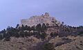
Pulpit Rock, in the northeastern part of the city
-
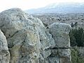
Palmer Park, also in the northeastern part of the city
-
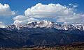
Pikes Peak looking west from the University of Colorado Colorado Springs campus
-
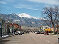
Downtown Colorado Springs
.jpg)
.jpg)


