
George River (Quebec) facts for kids
Quick facts for kids George River |
|
|---|---|
 |
|

Map of the George River basin
|
|
| Other name(s) | Rivière George |
| Country | Canada |
| Province | Quebec |
| Region | Nord-du-Québec |
| Physical characteristics | |
| Main source | Lake Jannière Lac-Juilet Unorg. Territory, Caniapiscau RCM 488 m (1,601 ft) 54°51′30″N 63°55′30″W / 54.85833°N 63.92500°W |
| River mouth | Ungava Bay 18 km NW of Kangiqsualujjuaq, Kativik 0 m (0 ft) 58°49′00″N 66°10′00″W / 58.81667°N 66.16667°W |
| Length | 565 km (351 mi) |
| Basin features | |
| Basin size | 41,700 km2 (16,100 sq mi) |
The George River (also known as Rivière George) is a long river in northeastern Quebec, Canada. It flows mainly north from Lake Jannière all the way to Ungava Bay.
This river is known by different names in local languages. The Inuit call it Kangirsualujjuap Kuunga, which means "River of the Great Bay". The Naskapi people call it Mushuan Shipu, meaning "River without Trees". The Innu people know it as Metsheshu Shipu, or "Eagle River".
The George River is very wide and powerful. It is a popular spot for canoe camping because it offers easier access to Ungava Bay compared to other big rivers nearby.
Contents
Exploring the George River's Geography
The George River starts in Lake Jannière, about 175 kilometres (109 mi) east of Schefferville. This area is full of wet, marshy lands. The lakes where the river begins are shallow. They are connected by fast-moving sections of water called rapids.
River's Journey and Challenges
After Lake Advance, the river flows through many difficult whitewater sections. It then reaches Indian House Lake. This lake is very long, stretching about 60 kilometres (37 mi) or even 100 kilometres (62 mi) if you count its calm, flat parts.
Once past Indian House Lake, the George River becomes even more powerful. It has many rapids of different difficulty levels. These continue until the river reaches Kangiqsualujjuaq, a community close to Ungava Bay. Because the river is so big and strong, it can be dangerous. People who travel on it must have the right skills and experience. The weather can also be very cold, leading to hypothermia. In the last 40 kilometres (25 mi) of the river, canoeists must also deal with strong tides.
A Look at the George River's History
The George River got its current name on August 12, 1811. Two Moravian missionaries, Benjamin Gottlieb Kohlmeister and George Kmoch, named it. They traveled from Labrador to Ungava Bay to share their faith with the Inuit people.
How the River Got Its Name
In their diary, the missionaries wrote about naming the river. They said: "We then proclaimed the name of the Kangertlualuksoak to be henceforth George River." After this, everyone fired their guns three times to celebrate. The missionaries wanted to honor King George III. He was the King of Great Britain and Ireland from 1760. In 1769, he gave the Moravians land on the Labrador coast to build settlements.
Early Trading Posts and Expeditions
In 1838, John McLean set up a trading post called Fort Severight (now Kangiqsualujjuaq) at the mouth of the George River. McLean worked for the Hudson's Bay Company. The local Inuit people did not live around the post. They preferred to camp along the coast in summer and move inland in winter.
In 1839, McLean tried to find a land route between Ungava Bay and Fort Smith (now North West River). His journey was not successful. He discovered the Grand Falls (now Churchill Falls) and had to turn back. In the winter of 1839–1840, they built a small post called Fort Trial on Indian House Lake. This post was meant to be a stop for supplies. However, it was soon no longer needed. The Hudson's Bay Company closed its trading operations in the Ungava area, including Fort Trial and Fort Severight, around 1842.
The old fort at the river's mouth was reopened in 1876 by the Hudson's Bay Company. They wanted to get back the trade from the local Indigenous peoples. The post closed and reopened a few times. It mostly served as a fishing spot for Fort Chimo until it finally closed in June 1952.
The George River was also part of several famous canoe trips. The Leonidas Hubbard expedition in 1903 faced difficulties here. Later, successful expeditions by Mina Benson Hubbard and Dillon Wallace in 1905, and Hesketh Hesketh-Prichard in 1910, also followed the George River.
The George River Caribou Herd

The George River caribou herd (GRCH) lives in the Ungava Peninsula region of Quebec and Labrador. This herd was once the largest caribou herd in the world. It had between 800,000 and 900,000 animals. These caribou are a type of boreal woodland caribou. However, they are different because they migrate long distances, like barren-ground caribou.
Decline of the Caribou Population
The number of caribou in the George River herd has dropped a lot. In the 1980s, there were 700,000 to 800,000 caribou. By 2010, this number fell to 74,000. By 2012, it was only 27,600, and by 2014, there were just 14,200 caribou left.
Even though these caribou are technically woodland caribou, their behavior is more like barren-ground caribou. They travel thousands of kilometers from forests to open tundra. Most female caribou give birth in the tundra within a three-week period.
According to a National Geographic article, the herd was very small in the late 1940s, with only 3,500 animals. It grew to 700,000 by 1988 and 775,000 by 1993. But then the numbers started to fall sharply. By 2001, there were 385,000, and by 2010, only 75,000. The most recent survey shows fewer than 28,000 caribou.
| year | population |
|---|---|
| late 1940s | 3,500 |
| 1958 | 15,000 |
| 1988 | 700,000 |
| mid-1990s | 750,000 |
| 2001 | 385,000 |
| 2011 | 74,000 |
| 2012 | 27,600 |
| 2014 | 14,200 |
Since the mid-1990s, the herd has declined by up to 92%. A survey in 2011 confirmed this ongoing drop.
Efforts to Protect the Caribou
In January 2013, Indigenous groups like the Innu, Inuit, and Cree from Quebec and Labrador held important meetings. They formed the Ungava Peninsula Caribou Aboriginal Round Table. They released a joint statement about the "critical decline" of the George River Caribou Herd.
The land is changing and the impacts of climate change, industrial development, and the growing human population and easier accessibility of the herd cannot be ignored in the management actions to be put forward. With the exponential rate of development, the protection of caribou habitat is greatly deficient and needs to be addressed seriously.
The Government of Nunatsiavut suggested protecting the caribou's calving grounds. They recommended creating a 14,000 square kilometer protection zone. This would help keep the area safe for the caribou to have their young.
Image gallery
-
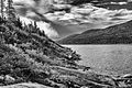
The George River in August 2018
-
Helen's Falls, a rapid on the river
-
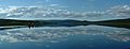
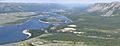
A wide view of Indian House Lake
-
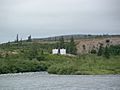
An old US Army weather station on Indian House Lake
-
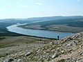
A view of the George River from a hike to Pyramid Peak
-
Another panoramic view of the George River from Pyramid Peak
-
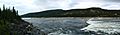
A panoramic view of Helen Falls
-
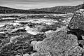
The Sarvakallak Rapid
-
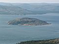
Ford Island in the George River
-
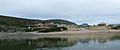
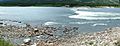
Kangiqsualujjuaq Harbour during high tide


.jpg)
See also
 In Spanish: Río George (Quebec) para niños
