Gibraltar Creek facts for kids
Quick facts for kids Gibraltar Creek |
|
|---|---|

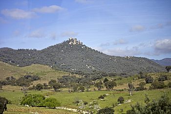
Gibraltar Creek in the foreground, with Gibraltar Peak in the district of Paddys River.
|
|
| Country | Australia |
| Territory | Australian Capital Territory |
| Region | South Eastern Highlands (IBRA), Capital Country |
| Physical characteristics | |
| Main source | Brindabella Ranges Billy Billy Rocks in Tidbinbilla Nature Reserve 1,420 m (4,660 ft) 35°29′8.97″S 148°56′2.63″E / 35.4858250°S 148.9340639°E |
| River mouth | confluence with Paddys River 647 m (2,123 ft) 35°26′30.55″S 148°58′57.1″E / 35.4418194°S 148.982528°E |
| Length | 13 km (8.1 mi) |
| Basin features | |
| River system | Murrumbidgee River, Murray–Darling basin |
| Falls | Gibraltar Falls |
Gibraltar Creek is a stream in the Australian Capital Territory (ACT), Australia. It flows all year round. This creek is part of the larger Murrumbidgee River system. The Murrumbidgee River then flows into the Murray–Darling basin, which is a huge area of land drained by the Murray and Darling Rivers.
Along the banks of Gibraltar Creek, you can find different types of Greenhood orchids. Scientists have also discovered old Aboriginal campsites near the creek. These sites show that people have lived here for a very long time.
Where is Gibraltar Creek Located?
Gibraltar Creek starts high up in the Brindabella Range mountains. It begins on the eastern side of these mountains in the south-west part of the ACT. The creek's starting point is below a place called Billy Billy Rocks. This area is inside the Tidbinbilla Nature Reserve and also part of Namadgi National Park.
The creek generally flows towards the north-east. It travels about 13 km (8.1 mi) before it meets another river. This meeting point, called a confluence, is where Gibraltar Creek joins Paddys River. This spot is located south-west of the Tuggeranong Town Centre. From its source in the mountains to where it joins Paddys River, Gibraltar Creek drops about 774 metres (2,539 ft) in height.
A beautiful waterfall, known as Gibraltar Falls, is found on Gibraltar Creek. There is also a special area called Gibraltar Creek Woods Reserve right next to the creek.
Plants and Animals Around the Creek
The area around Gibraltar Creek is home to many interesting plants. Some of these plants are considered threatened, meaning they are rare and need protection. These include different types of Greenhood orchids, such as Scarlet Greenhoods, Fisch's Greenhood, Faint Greenhoods, Nodding Greenhoods, and Maroonhoods.
Other plants found near the creek include types of Eucalyptus trees, like E. callianassa, and different kinds of Banksia plants, including B. marginata.
In 1930, a nearby river, the Cotter River, was stocked with New Zealand trout fish. It was hoped that these trout would swim upstream into smaller waterways, including Gibraltar Creek.
A Glimpse into the Creek's Past
As mentioned, historical Aboriginal campsites have been found along the banks of Gibraltar Creek. These discoveries help us learn about the ancient history of the area.
In 1863, land next to the creek was sold to new owners. The creek has sometimes caused challenges for people living nearby. In late 1933 and early 1934, the creek flooded several times. This made it very hard to cross. People even suggested covering the creek bed with cement to make crossing easier during floods. By 1934, special ramps were built to help people cross the creek, replacing old gates that were used for cattle.
In the 1950s, groups of bushwalkers often organized trips to explore the areas around Gibraltar Creek. In 1954, some hikers got lost near the creek, and a search party had to look for them.
 | Lonnie Johnson |
 | Granville Woods |
 | Lewis Howard Latimer |
 | James West |

