Glebe, Queensland facts for kids
Quick facts for kids GlebeQueensland |
|||||||||||||||
|---|---|---|---|---|---|---|---|---|---|---|---|---|---|---|---|

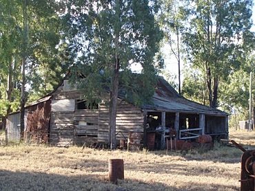
Machinery Shed at The Glebe Homestead, 2009
|
|||||||||||||||
| Population | 10 (2021 census) | ||||||||||||||
| • Density | 0.015/km2 (0.039/sq mi) | ||||||||||||||
| Postcode(s) | 4419 | ||||||||||||||
| Area | 646.2 km2 (249.5 sq mi) | ||||||||||||||
| Time zone | AEST (UTC+10:00) | ||||||||||||||
| Location | |||||||||||||||
| LGA(s) | Shire of Banana | ||||||||||||||
| State electorate(s) | Callide | ||||||||||||||
| Federal Division(s) | Flynn | ||||||||||||||
|
|||||||||||||||
Glebe is a small countryside area in Queensland, Australia. It is part of the Shire of Banana. In 2021, only 10 people lived there, making it a very quiet place.
Geography of Glebe
Glebe is located near the Dawson River. This river forms the north-western border of the area. A special dam, called the Glebe Weir, holds back the river's water in the south-west.
Land Use and Farming
Most of the land in Glebe is used for grazing animals, like cattle. These animals eat the natural plants that grow there. There is also a small amount of crop farming. These crops are grown in the north-west, close to the Dawson River. Some crops near the weir use water from the river to help them grow.
Population of Glebe
Glebe is a very small community. In 2016, 24 people lived there. By 2021, the population had changed to 10 people.
Historic Places in Glebe
Glebe has some places that are listed as important heritage sites. This means they are special because of their history or culture. One of these sites is:
- The The Glebe Homestead, located on the Taroom-Cracow Road.
 | Leon Lynch |
 | Milton P. Webster |
 | Ferdinand Smith |


