Glendale, Utah facts for kids
Quick facts for kids
Glendale, Utah
|
|
|---|---|

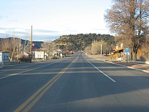
U.S. Route 89 passing through Glendale
|
|

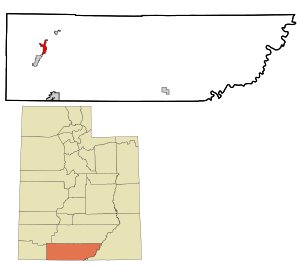
Location in Kane County and the state of Utah
|
|

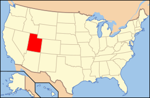
Location of Utah in the United States
|
|
| Country | United States |
| State | Utah |
| County | Kane |
| Founded | 1862 |
| Incorporated | March 29, 1935 |
| Area | |
| • Total | 7.00 sq mi (18.12 km2) |
| • Land | 7.00 sq mi (18.12 km2) |
| • Water | 0.00 sq mi (0.00 km2) |
| Elevation | 5,778 ft (1,761 m) |
| Population
(2010)
|
|
| • Total | 381 |
| • Estimate
(2019)
|
407 |
| • Density | 58.18/sq mi (22.46/km2) |
| Time zone | UTC-7 (Mountain (MST)) |
| • Summer (DST) | UTC-6 (MDT) |
| ZIP code |
84729
|
| Area code(s) | 435 |
| FIPS code | 49-29360 |
| GNIS feature ID | 1428204 |
Glendale is a small town located in Kane County, Utah, in the United States. In 2010, about 381 people lived there. It is a quiet place with a rich history in a beautiful valley.
Contents
History of Glendale
Early Settlement and Naming
In 1862, ranchers came to the area known as Long Valley. They grazed their cattle along the East Fork of the Virgin River. Robert and Isabella Berry were among these early settlers. They named the area "Berryville."
However, in 1866, after some local indigenous tribes attacked the Berrys, the other settlers decided to leave the area.
New Beginnings and Growth
In 1871, a new group of settlers arrived. These were Mormons from a settlement called Muddy River in Nevada. They decided to make this valley their new home. They renamed the town "Glendale."
Some people believe the town was named for the lovely "glens" (small valleys) and "dales" (valleys) nearby. Others think it was named after Glendale, Scotland, which was the homeland of some of the first settlers. Many people from St. Thomas, Nevada, moved to Glendale at this time.
By the late 1800s, other Mormon communities grew in nearby towns like Orderville and Mt Carmel Junction. Glendale became part of a special program called the United Order. This program, started in 1874 by Brigham Young, focused on economic and moral improvements for the community.
On March 29, 1935, Glendale officially became an incorporated town. Today, Glendale, Mount Carmel, and Orderville are known together as the Long Valley towns.
Geography and Location
Glendale is found in the western part of Kane County, Utah. It sits at an elevation of about 5,778 feet (1,761 meters) in a place called Long Valley. The East Fork of the Virgin River flows through this valley.
U.S. Route 89 is a main road that goes through Glendale. This highway follows the valley and connects Glendale to other towns. It leads southwest about 4 miles (6.4 km) to Orderville. It also goes north about 41 miles (66 km) to Panguitch.
The United States Census Bureau says that Glendale covers a total area of about 7.00 square miles (18.12 square kilometers). All of this area is land, with no water.
Exploring Nearby Areas
If you head east from Glendale on Glendale Bench Road, you can reach the Grand Staircase–Escalante National Monument (GSENM). This road is rustic and offers beautiful views. It connects with Skutumpah Road, which runs through the monument. Skutumpah Road ends at one of the GSENM Visitor Centers in Cannonville, which is close to Bryce Canyon.
Population and People
| Historical population | |||
|---|---|---|---|
| Census | Pop. | %± | |
| 1880 | 338 | — | |
| 1890 | 253 | −25.1% | |
| 1900 | 319 | 26.1% | |
| 1910 | 244 | −23.5% | |
| 1920 | 250 | 2.5% | |
| 1930 | 239 | −4.4% | |
| 1940 | 297 | 24.3% | |
| 1950 | 226 | −23.9% | |
| 1960 | 223 | −1.3% | |
| 1970 | 200 | −10.3% | |
| 1980 | 237 | 18.5% | |
| 1990 | 282 | 19.0% | |
| 2000 | 355 | 25.9% | |
| 2010 | 381 | 7.3% | |
| 2019 (est.) | 407 | 6.8% | |
| Source: U.S. Census Bureau | |||
According to the census from 2000, there were 355 people living in Glendale. These people made up 116 households, with 88 of them being families. The town had about 45.5 people per square mile (17.6 per km2).
Most of the people in Glendale were White (99.15%). A small number were Native American (0.56%) or from two or more races (0.28%). About 3.94% of the population identified as Hispanic or Latino.
Household Information
In 2000, about 38.8% of households had children under 18 living with them. Most households (71.6%) were married couples living together. About 20.7% of all households were made up of individuals living alone.
The average household size was about 3 people. The average family size was about 3.6 people.
Age Distribution
The population of Glendale was spread out across different age groups. About 34.1% of the people were under 18 years old. About 13.2% were 65 years of age or older. The average age in the town was 31 years old.
For every 100 females, there were about 107.6 males in the town.
See also
 In Spanish: Glendale (Utah) para niños

