Goldsborough (hill) facts for kids
Quick facts for kids Goldsborough |
|
|---|---|

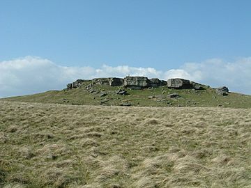
Southern side of Goldsborough
|
|
| Highest point | |
| Elevation | 389 m (1,276 ft) |
| Prominence | 29 m (95 ft) |
| Listing | (none) |
| Geography | |
| Location | County Durham, England |
| Parent range | North Pennines |
| OS grid | NY957175 |
| Topo map | Ordnance Survey Landranger 92 |
Goldsborough is a small hill in the Pennines. The Pennines are a famous range of hills and moors. They run right through the middle of Northern England. Goldsborough stands 388 meters (1,273 feet) tall.
This hill is located in County Durham. It is also within the old borders of Yorkshire. Goldsborough lies about two miles south of a place called Hury. This area is part of Baldersdale. It is found just east of the main water divide of the Pennines. This means the water on one side flows in a different direction than on the other.
Exploring Goldsborough
Goldsborough is surrounded by a large area of wet, marshy moorland. This type of land is often covered in heather and grass. It is a great place for nature lovers.
You can climb Goldsborough from Baldersdale or Bowes. The hill has a very special flat top. This flat top is part of a walking path. It is called the Bowes Loop of the Pennine Way. The Pennine Way is a very long and famous walking trail. It stretches across the Pennine hills.
 | Madam C. J. Walker |
 | Janet Emerson Bashen |
 | Annie Turnbo Malone |
 | Maggie L. Walker |

