Goss Moor facts for kids
| Site of Special Scientific Interest | |

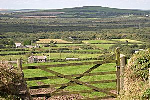
View over Goss Moor
|
|
| Coordinates | 50°24′17″N 4°53′04″W / 50.4047°N 4.8845°W |
|---|---|
| Interest | Biological |
| Area | 701.9 hectares (7.019 km2; 2.710 sq mi) |
| Notification | 1988 |
Goss Moor is a special nature reserve in Cornwall, England. It is about 12 kilometers (7.5 miles) southwest of Bodmin. This amazing area is the largest continuous wetland in southwest Britain. It is mostly made of peatland and lowland heath. These are very important habitats for many plants and animals.
Goss Moor and the nearby Tregoss Moor are protected areas. They are known as the Goss And Tregoss Moors Site of Special Scientific Interest (SSSI). They are also part of the Breney Common and Goss and Tregoss Moors Special Area of Conservation (SAC). This means they are very important for nature and wildlife.
Contents
A Look Back: History of Goss Moor
People have used Goss Moor for a long time. Before 1838, a writer named Davies Gilbert said that the flat land around St Dennis was "destroyed." This was because people were "streaming for tin." This means they dug up the ground to find tin metal. They would wash the soil to separate the tin.
Later, between 1908 and 1916, bigger machines were used. These were steam-powered dredges. They were like giant vacuum cleaners that sucked up the soil. They helped mine about 70 tons of tin from the moor. After this, the dredges were moved to other areas like Breney Common and Red Moor.
In 1988, Goss and Tregoss Moors officially became a Site of Special Scientific Interest. This helped protect the area and its unique nature.
Exploring the Geography of Goss Moor
Goss Moor is located about 12 kilometers (7.5 miles) southwest of Bodmin. It has some interesting natural features around it. To the north, you can see Castle an Dinas, which is an old hill fort. To the south, you can spot the church of St Dennis.
The River Fal actually starts on Goss Moor, near a place called Pentivale. It then flows for about 17 kilometers (10.5 miles) all the way to the English Channel. It ends up in a beautiful area called Carrick Roads.
For many years, the main A30 road used to go right through the middle of Goss Moor. This caused a lot of traffic jams. People wanted to make the road bigger, but others wanted to protect the moor. Finally, a new dual carriageway was built to the north of the moor. It opened in 2007. Much of the old road is now a special cycle lane, which opened in 2008. This is great for cyclists! The Atlantic Coast railway line also crosses Goss Moor, connecting Par and Newquay.
Amazing Plants and Animals of Goss Moor
Goss Moor is home to many special and rare species. These include unique plants and interesting insects.
Rare Plants
- Yellow centaury (Cicendia filiformis)
- Marsh clubmoss
Special Invertebrates
- Small red damselfly
- Variable damselfly
Beautiful Butterflies
- Silver-studded blue
- Marsh fritillary
- Small pearl-bordered fritillary
- Grizzled skipper
Unique Moths
- Narrow-bordered bee hawk
- Double line
A study in 2003 found twelve different types of "poor fen" plant groups in the area. This shows how diverse and important the plant life is on Goss Moor.
 | Janet Taylor Pickett |
 | Synthia Saint James |
 | Howardena Pindell |
 | Faith Ringgold |

