Granby, New York facts for kids
Quick facts for kids
Granby, New York
|
|
|---|---|

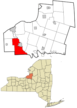
Location in Oswego County and the state of New York.
|
|
| Country | United States |
| State | New York |
| County | Oswego |
| Area | |
| • Total | 46.35 sq mi (120.05 km2) |
| • Land | 44.65 sq mi (115.64 km2) |
| • Water | 1.70 sq mi (4.41 km2) |
| Elevation | 436 ft (133 m) |
| Population
(2010)
|
|
| • Total | 6,821 |
| • Estimate
(2016)
|
6,578 |
| • Density | 147.33/sq mi (56.88/km2) |
| Time zone | UTC-5 (Eastern (EST)) |
| • Summer (DST) | UTC-4 (EDT) |
| ZIP code |
13069
|
| Area code(s) | 315 |
| FIPS code | 36-29729 |
| GNIS feature ID | 0979011 |
Granby is a small town located in Oswego County, New York, in the United States. In 2010, about 6,821 people lived here.
The Town of Granby is found in the southwest part of Oswego County.
Contents
Granby's Early Days
People first started settling in the Granby area around 1792. The town of Granby was officially created in 1818. It was formed from parts of the Town of Hannibal and the Town of Lysander. A small northern section of Granby became part of the Town of Oswego in 1836.
Where is Granby Located?
Granby covers an area of about 46.5 square miles (120 square kilometers). Most of this area is land, with a small part being water.
The eastern border of Granby is along the Oswego River. This side also touches the City of Fulton. To the south, Granby shares a border with Onondaga County. On its west side, Granby borders the town of Hannibal. To the north, it borders the towns of Oswego and Minetto.
Who Lives in Granby?
Here's how the population of Granby has changed over the years:
| Historical population | |||
|---|---|---|---|
| Census | Pop. | %± | |
| 1820 | 555 | — | |
| 1830 | 1,423 | 156.4% | |
| 1840 | 2,385 | 67.6% | |
| 1850 | 2,344 | −1.7% | |
| 1860 | 4,057 | 73.1% | |
| 1870 | 3,972 | −2.1% | |
| 1880 | 4,514 | 13.6% | |
| 1890 | 2,317 | −48.7% | |
| 1900 | 2,195 | −5.3% | |
| 1910 | 2,022 | −7.9% | |
| 1920 | 1,913 | −5.4% | |
| 1930 | 2,130 | 11.3% | |
| 1940 | 2,220 | 4.2% | |
| 1950 | 2,775 | 25.0% | |
| 1960 | 3,704 | 33.5% | |
| 1970 | 4,718 | 27.4% | |
| 1980 | 6,341 | 34.4% | |
| 1990 | 7,013 | 10.6% | |
| 2000 | 7,009 | −0.1% | |
| 2010 | 6,821 | −2.7% | |
| 2016 (est.) | 6,578 | −3.6% | |
| U.S. Decennial Census | |||
In 2000, there were 7,009 people living in Granby. The population was spread out in terms of age. About 28% of the people were under 18 years old. The average age in Granby was 36 years.
Schools in Granby
Granby does not have its own school district. Instead, students living in Granby attend schools in several nearby districts. These include the Fulton City School District, Phoenix School District, Hannibal Central School District, and Cato-Meridian School District. These districts provide education from kindergarten through 12th grade.
Places to See in Granby
Granby has several interesting communities and locations:
- Battle Island State Park – This is a state park located on the western bank of the Oswego River. You can find it in the northeast part of the town.
- Bowens Corners – This hamlet is southwest of Fulton, along Route 176. It used to be called Liberty's Corners.
- Dexterville – A small community on the western edge of the town, west of Granby Center.
- Granby Center – This hamlet is in the northern part of the town. It was once known as "Williams Corners" and is west of Fulton on Route 3.
- Hinmansville – A hamlet located in the southern part of the town, near the Oswego River.
- Lake Neatahwanta – This is a community located by a lake to the west of the City of Fulton.
- Lewis Corners – A hamlet north of Granby Center, close to the Minetto town line.
- Ox Creek – This is a small stream that flows into the Oswego River.
- Pember Corners – A hamlet located on the town line in the northwestern part of Granby.
- South Granby – A hamlet in the southern part of the town, northwest of Hinmansville.
- West Granby – This was a community that used to exist in the town.
- Brook – This was a post office located just north of the county line.
See also
 In Spanish: Granby (Nueva York) para niños
 | Delilah Pierce |
 | Gordon Parks |
 | Augusta Savage |
 | Charles Ethan Porter |

