
Grand Mesa facts for kids
The Grand Mesa is a huge, flat-topped mountain in western Colorado, United States. It's known as the largest flat-topped mountain in the world! This amazing natural wonder covers about 1,300 square kilometers (500 square miles). It stretches for about 64 kilometers (40 miles) east of Grand Junction. The Grand Mesa sits between the Colorado River and the Gunnison River.

The mesa rises about 1,800 meters (6,000 feet) above the nearby river valleys. Its highest points reach about 3,400 meters (11,000 feet) high. A big part of the mesa is inside the Grand Mesa National Forest. You can find over 300 lakes on top of the mesa. Many of these lakes are reservoirs, used to store water for drinking and farming. While some areas of the Grand Mesa are very flat, others are quite rugged and uneven.
How Grand Mesa Was Formed
The top of the Grand Mesa is covered by a very hard layer of volcanic rock called basalt. This basalt layer formed a long time ago, between 10.9 and 9.6 million years ago. It was created by at least 27 different lava flows that erupted from vents in the area. This created a thick layer of basalt, more than 93 meters (300 feet) deep.
This tough basalt layer helped protect the mesa from erosion. The rivers around it, like the Colorado and Gunnison, carved away the softer sedimentary rock layers. But the hard basalt on top kept the mesa from wearing down as quickly.
Below the basalt, there are layers of shale and sandstone. These layers sit on an even older layer called the Mesaverde Group, which forms a cliff partway up the mesa's sides. The very bottom layers are yellow and gray Mancos Shale. This shale extends into the valleys around the mesa, creating rich soil that's great for agriculture, especially in the Gunnison Valley.
Scientists believe the lava flows that formed the Grand Mesa might have once covered an area of 1,300 square kilometers (500 square miles). But over millions of years, erosion has worn away much of it, leaving about 166 square kilometers (64 square miles) of the original flows.
Grand Mesa's Climate
The weather on Grand Mesa changes a lot depending on how high up you are. Higher parts of the mesa are cooler and get more rain and snow. The very top of the mesa is over 3,200 meters (2 miles) above sea level. This means it has an alpine climate, which is like a mountain climate, with lots of precipitation all year.
Because it's so high, summer days are mild and pleasant. But temperatures drop quickly after the sun sets. In winter, temperatures rarely go above freezing. It can get extremely cold, often falling far below zero, especially at night.
The top of the mesa is usually clear of snow from late June to early October. However, it gets a lot of snow in winter. It's common for more than 760 centimeters (300 inches) of snow to fall! This heavy snowfall makes many of the forest roads impossible to use. Areas around the mesa, at lower elevations, are warmer and much drier throughout the year.
Exploring Grand Mesa
You can drive across the Grand Mesa on the Grand Mesa Scenic and Historic Byway. This road includes SH 65. It connects the town of Mesa in the north to Cedaredge in the south. Driving this route shows you a dramatic change in scenery, weather, and plants.
On the north side, the road climbs steeply near the Powderhorn Resort ski area. The forests on top of the mesa stay covered in snow much later in the spring than the valleys below. This makes it a popular spot for cross-country skiing and snowmobiling during the winter months.

Images for kids
-
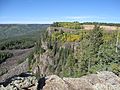
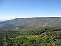
Cliff edge on the western side of the mesa.
-
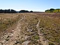
A typical landscape on top of the mesa.
-
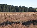
In the summer, cattle graze on the mesa.
-
A view from Grand Mesa looking south towards Island Lake and the San Juan Mountains.
-
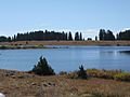
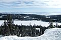
Many ponds and small lakes dot the top of the Mesa.
-
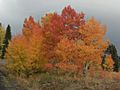
Beautiful fall colors atop the mesa.
-
The western edge of the mesa.
-
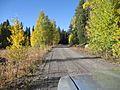
A typical Forest Service road atop the mesa.
-
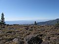
The view towards Grand Junction.
-
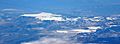
An aerial photograph of Grand Mesa.


