Green River (Duwamish River tributary) facts for kids
Quick facts for kids Green River |
|
|---|---|

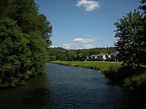
Looking upriver from suspension bridge in Isaac Evans Park, Auburn, Washington
|
|

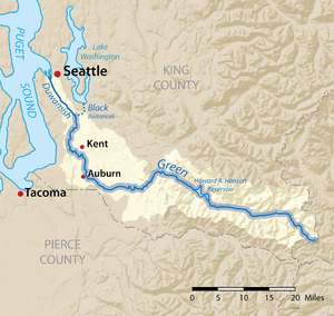
Map of the Duwamish/Green River watershed with the Green River highlighted
|
|
|
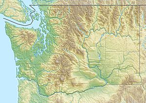
Location of the mouth of the Duwamish River in Washington
|
|
| Country | United States |
| State | Washington |
| County | King |
| Cities | Auburn, Kent, Tukwila |
| Physical characteristics | |
| Main source | Cascade Range 3,283 ft (1,001 m) 47°8′N 121°18′W / 47.133°N 121.300°W |
| River mouth | Duwamish River 57 ft (17 m) 47°28′N 122°15′W / 47.467°N 122.250°W |
| Length | 65 mi (105 km) |
| Basin features | |
| Basin size | 440 sq mi (1,100 km2) |
The Green River is a 65-mile (105 km) long river located in the state of Washington, USA. It starts high up on the western side of the Cascade Range mountains, south of Interstate 90.
The upper part of the Green River valley leads to Stampede Pass. This area used to have many small towns built around railroads and logging, like Weston and Lester. Today, much of this upper valley is a special area that provides water supply for the city of Tacoma, Washington. Access to this area is very limited.
Between 1880 and 1888, the Northern Pacific Railway explored the Green River area. They built the first direct train route across Washington's Cascade Range. This happened when their Stampede Tunnel opened in 1888.
Green River History
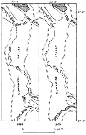
Before 1906, the Green River flowed into the White River in downtown Auburn. But in 1906, a big flood caused the White River to change its path. After that, the White River started flowing into the Puyallup River, which it still does today.
The lower part of what used to be the White River is now considered part of the Green River. This section goes from where the White and Green Rivers used to meet, all the way to where the White River used to join the Black River in Tukwila. This meeting point formed the Duwamish River.
Then, in 1916, the Lake Washington Ship Canal opened. This caused the lake's water level to drop by almost nine feet, and the Black River dried up completely. So, the Green River now directly becomes the Duwamish River. This part of the river flows into the industrial estuary called the Duwamish Waterway and then into Elliott Bay in Seattle. The White River, however, turns south at Auburn and flows into the Puyallup River, eventually reaching Commencement Bay in Tacoma.
In October 2009, large sandbags were placed along the river's edge from Fort Dent through Kent. The Green River Trail, a popular path for cyclists, was closed. This was done to help prevent floods. A problem was found in the Howard A. Hanson Dam after a storm in January 2009. The Army Corps of Engineers worked to fix and strengthen the dam. These repairs greatly reduced the risk of flooding. In September 2012, the Green River Trail was reopened after all the sandbags were removed.
Green River Course
Most of the Green River, including the area around Eagle Gorge Reservoir, is part of the Green River Watershed. This area is closed to the public. This has caused some debate among people who enjoy outdoor activities.
West of the Green River Watershed, near Kanaskat, the river flows through the Green River Gorge. Here, tall cliffs rise sharply, as much as 300 feet (91 m) from the riverbed. You can find Flaming Geyser State Park, Nolte State Park, and Kanaskat-Palmer State Park in this beautiful area. The river is a popular spot for tubing during the summer months.
Downstream from the Green River Gorge is the Green River Valley, which is about half a mile wide. The farmland here has been protected from new buildings. There was an idea to build a bike trail along the valley walls, but local farmers strongly disagreed. So, bikes and cars now share the road as it winds through the peaceful countryside.
At Auburn, the Green River leaves the Green River Valley and enters the much larger Auburn/Kent Valley. This valley was formed by glaciers during the Pleistocene ice ages. Later, it was filled in by river sediments and mudflows (called lahars) from Mount Rainier. After flowing generally west from its source, the river turns north at Auburn. It then flows through an area with light industrial buildings and shops. A public path for walking and biking runs along the river through most of this valley.
Green River Tributaries
The Green River has several smaller streams and creeks that flow into it. These are called tributaries. Some of them include:
- Big Soos Creek
- Covington Creek
- Crisp Creek
- Jenikins Creek
- Little Soos Creek
- Longfellow Creek
- Mill Creek
- Newaukum Creek
- Springbrook Creek
See also
 In Spanish: Río Green (Washington) para niños
 | Aurelia Browder |
 | Nannie Helen Burroughs |
 | Michelle Alexander |


