Greene, Rhode Island facts for kids
Quick facts for kids
Greene, Rhode Island
|
|
|---|---|

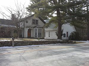
Greene Community Church and House
|
|

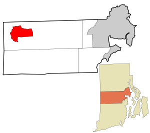
Location in Kent County and the state of Rhode Island
|
|
| Country | United States |
| State | Rhode Island |
| County | Kent |
| Town | Coventry |
| Area | |
| • Total | 6.09 sq mi (15.78 km2) |
| • Land | 6.07 sq mi (15.73 km2) |
| • Water | 0.02 sq mi (0.04 km2) |
| Elevation | 558 ft (170 m) |
| Population
(2020)
|
|
| • Total | 914 |
| • Density | 150.48/sq mi (58.10/km2) |
| Time zone | UTC−5 (Eastern) |
| • Summer (DST) | UTC−4 (Eastern) |
| ZIP Code |
02827
|
| Area code(s) | 401 |
| FIPS code | 44-31240 |
| GNIS feature ID | 1219521 |
Greene is a small community in the western part of Coventry, Rhode Island, United States. It's known as a census-designated place, which means it's a specific area defined for counting people. In 2020, about 914 people lived there. Greene is located about 2 miles (3.2 km) east of the Connecticut border. It's also 2 miles (3.2 km) north of West Greenwich. The community gets its name from Nathanael Greene, a famous general from Rhode Island who fought in the American Revolution.
Contents
Greene's Past: A Village Grows
From Swamp to Train Stop
Before 1854, Greene was mostly a swampy area. A simple dirt path ran through it. This path connected a place called Hopkins Hollow to the south with Rice City to the north.
In the early 1850s, something big happened: the railroad came to the area! The first train stop was called "Coffin Station." This was because Coffin Road was the closest road to it.
The Railroad's Impact
In 1856, railroad officials decided to change the station's name to "Greene." They named it after the Revolutionary War hero, Nathanael Greene. They also decided to build a special depot. This was a place where local farmers could sell their crops and goods. Trains heading to Providence and Hartford would pick up these products.
Soon, the Greene depot became very important. It was the busiest station in western Rhode Island. Every morning, farmers would bring their fresh produce. A special "milk train" would leave at 7:25 AM, heading to Providence.
A Village Comes Alive
As the train station grew, a small village started to form around it. People sent lots of milk, wood, and cranberries by train. Over time, the community built important places like a school, a church, a library, and a meeting hall.
There was also a religious campground in the Greene area. The Advent Christian Church started holding annual "camp meetings" there in 1880. These meetings were very popular. The railroad even added extra train cars for people to attend. Up to 10,000 people would come to these summer events! These camp meetings were a big deal in Rhode Island.
Changes Over Time
In the early 1900s, cars became popular. This meant people didn't rely on trains as much. The railroad's importance slowly faded. In 1969, the train station finally closed.
Today, Greene is quieter than it used to be. However, many of the old buildings from the late 1800s are still standing. This helps the village keep its historic feel.
Greene's Location and Landscape
Where is Greene?
The Greene census-designated place includes several smaller communities. These are Greene itself, Fairbanks Corner, Rice City, and Summit.
Several main roads pass through or near Greene:
- Rhode Island Route 14 runs along the northern edge. It goes northeast about 23 miles (37 km) to Providence. To the west, it goes 7 miles (11 km) to Moosup, Connecticut.
- Rhode Island Route 117 goes through the middle of Greene. It connects Fairbanks Corner, Greene village, and Summit. It eventually leads about 16 miles (26 km) to Apponaug in Warwick.
- Rhode Island Route 102 forms the eastern border. It goes north 7 miles (11 km) to Clayville in Scituate. It also goes south the same distance to Interstate 95 in West Greenwich.
Green Spaces and Water
The Coventry Greenway is a special path that runs through Greene. It's part of the larger East Coast Greenway, which stretches from Maine to Florida. This path is a "rail trail," meaning it follows the route of the old New York, New Haven and Hartford Railroad. It's a great place for walking or biking!
Greene covers an area of about 6.1 square miles (15.8 square kilometers). Most of this is land. Only a tiny part, about 0.02 square miles (0.04 square kilometers), is water. The Moosup River flows through the community. This river then flows west into the Quinebaug River in Connecticut.
Greene's Population
| Historical population | |||
|---|---|---|---|
| Census | Pop. | %± | |
| 2020 | 914 | — | |
| U.S. Decennial Census | |||
Who Lives in Greene?
The 2020 United States census counted 914 people living in Greene. There were 325 households, which are groups of people living together. Most people in Greene are white. A small number of people are black, Asian, or from two or more races. About 2.6% of the population is Hispanic or Latino.
Families and Ages
Many households in Greene are married couples living together. About 31% of households have children under 18. The average household has about 3 people.
The population of Greene includes people of all ages:
- 22.3% are under 18 years old.
- 6.9% are between 18 and 24.
- 22.9% are between 25 and 44.
- 31.1% are between 45 and 64.
- 16.8% are 65 years old or older.
The average age in Greene is about 43.3 years old.
See also
 In Spanish: Greene (Rhode Island) para niños
 | Audre Lorde |
 | John Berry Meachum |
 | Ferdinand Lee Barnett |


