
List of municipalities in Rhode Island facts for kids
.svg)


Rhode Island is a small but mighty state located in the Northeastern United States. Even though it's the smallest state by land area, it's home to over 1 million people! In fact, the 2020 United States Census showed that about 1,097,379 people live there.
Rhode Island is divided into 39 local areas called municipalities. These include 8 cities and 31 towns. Unlike most other states, Rhode Island doesn't have a county government. This means that the cities and towns handle many services that counties usually do elsewhere. Every person in Rhode Island lives within one of these cities or towns.
Contents
How Rhode Island's Cities and Towns Work
Cities and towns in Rhode Island can become official by a special decision from the state government. There's no rule about how many people need to live there for it to become a city or town. Eight of these areas are called "cities" and have their own special rules, while the other 31 are called "towns" and work in a similar way.
Since there are no county governments, the cities and towns provide important services like managing local roads, schools, and public safety.
Different Ways Cities and Towns are Run
Cities and towns in Rhode Island can choose one of four main ways to run their local government:
- Council–manager system: In this system, people vote for a group of leaders called a council. This council then hires a professional manager to run the day-to-day operations of the city or town. The manager is like the CEO of the local government. Sometimes, a mayor is also elected, but their job is mostly to lead meetings, not to manage the daily tasks.
- Mayor–council system: Here, both the council and the mayor are elected by the people. The mayor has a lot of power and is in charge of running the city or town's daily business.
- Town council–town meeting system: This system is more common in smaller towns. There isn't a full-time manager or mayor in charge. Instead, important decisions are often made by citizens directly at special "town meetings."
- Administrator–council system: This is similar to the council-manager system, but the chief executive might be called an administrator.
Largest and Smallest Municipalities
The biggest city in Rhode Island by population is Providence, which is also the state capital. About 190,934 people live there.
On the other hand, the smallest municipality by population is New Shoreham, located on Block Island. It has about 1,410 people living there all year round.
When it comes to land area, Coventry is the largest, covering about 59 square miles (153 square kilometers). The smallest is Central Falls, which is only about 1.2 square miles (3.1 square kilometers).
Rhode Island and Hawaii are unique because every single one of their cities and towns has more than 1,000 people living in it!
Cities and Towns in Rhode Island
State capital and largest city
- Largest municipalities in Rhode Island by population
-
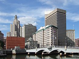
Downtown Providence, the capital and most populous city in Rhode Island
-
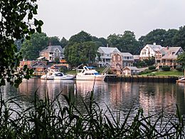
A view over Cranston, the second most populous city in Rhode Island
-
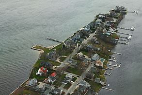
Boats and homes in Warwick, the third most populous city in Rhode Island
-
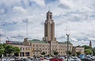
The city hall of Pawtucket, the fourth most populous city in Rhode Island

.jpg)
_--_2006_--_6.jpg)

| Name | Type | County | Form of government | Population (2020) |
Population (2010) |
Change | Land area (2020) |
Population density | Year established |
Year incorporated |
|
|---|---|---|---|---|---|---|---|---|---|---|---|
| sq mi | km2 | ||||||||||
| Barrington | Town | Bristol | Council–manager | 17,153 | 16,310 | +5.2% | 8.22 | 21.3 | 2,086.7/sq mi (805.7/km2) | 1653 | 1770 |
| Bristol | Town | Bristol | Council–manager | 22,493 | 22,954 | −2.0% | 9.82 | 25.4 | 2,290.5/sq mi (884.4/km2) | 1680 | 1746 |
| Burrillville | Town | Providence | Council–manager | 16,158 | 15,955 | +1.3% | 55.03 | 142.5 | 293.6/sq mi (113.4/km2) | 1730 | 1806 |
| Central Falls | City | Providence | Mayor–council | 22,583 | 19,376 | +16.6% | 1.20 | 3.1 | 18,819.2/sq mi (7,266.1/km2) | 1730 | 1895 |
| Charlestown | Town | Washington | Council–manager | 7,997 | 7,827 | +2.2% | 36.45 | 94.4 | 219.4/sq mi (84.7/km2) | 1669 | 1738 |
| Coventry | Town | Kent | Council–manager | 35,688 | 35,014 | +1.9% | 59.05 | 152.9 | 604.4/sq mi (233.4/km2) | 1639 | 1743 |
| Cranston | City | Providence | Mayor–council | 82,934 | 80,387 | +3.2% | 28.34 | 73.4 | 2,926.4/sq mi (1,129.9/km2) | 1754 | 1910 |
| Cumberland | Town | Providence | Mayor–council | 36,405 | 33,506 | +8.7% | 26.45 | 68.5 | 1,376.4/sq mi (531.4/km2) | 1746 | 1746 |
| East Greenwich | Town | Kent | Council–manager | 14,312 | 13,146 | +8.9% | 16.39 | 42.4 | 873.2/sq mi (337.1/km2) | 1677 | 1677 |
| East Providence | City | Providence | Mayor–council | 47,139 | 47,037 | +0.2% | 13.24 | 34.3 | 3,560.3/sq mi (1,374.6/km2) | 1812 | 1958 |
| Exeter | Town | Washington | Town meeting | 6,460 | 6,425 | +0.5% | 57.47 | 148.8 | 112.4/sq mi (43.4/km2) | 1641 | 1641 |
| Foster | Town | Providence | Town meeting | 4,469 | 4,606 | −3.0% | 50.80 | 131.6 | 88.0/sq mi (34.0/km2) | 1636 | 1781 |
| Glocester | Town | Providence | Town meeting | 9,974 | 9,746 | +2.3% | 54.18 | 140.3 | 184.1/sq mi (71.1/km2) | 1639 | 1730–1731 |
| Hopkinton | Town | Washington | Town meeting | 8,398 | 8,188 | +2.6% | 42.95 | 111.2 | 195.5/sq mi (75.5/km2) | 1639 | 1757 |
| Jamestown | Town | Newport | Council–manager | 5,559 | 5,405 | +2.8% | 9.45 | 24.5 | 588.3/sq mi (227.1/km2) | 1639 | 1678 |
| Johnston | Town | Providence | Mayor–council | 29,568 | 28,769 | +2.8% | 23.43 | 60.7 | 1,262.0/sq mi (487.3/km2) | 1636 | 1759 |
| Lincoln | Town | Providence | Council–manager | 22,529 | 21,105 | +6.7% | 18.12 | 46.9 | 1,243.3/sq mi (480.0/km2) | 1650 | 1871 |
| Little Compton | Town | Newport | Town meeting | 3,616 | 3,492 | +3.6% | 20.52 | 53.1 | 176.2/sq mi (68.0/km2) | 1682 | 1746 |
| Middletown | Town | Newport | Council–manager | 17,075 | 16,150 | +5.7% | 12.72 | 32.9 | 1,342.4/sq mi (518.3/km2) | 1639 | 1743 |
| Narragansett | Town | Washington | Council–manager | 14,532 | 15,868 | −8.4% | 13.89 | 36.0 | 1,046.2/sq mi (403.9/km2) | 1888 | 1901 |
| Newport | City | Newport | Council–manager | 25,163 | 24,672 | +2.0% | 7.67 | 19.9 | 3,280.7/sq mi (1,266.7/km2) | 1639 | 1784 |
| New Shoreham | Town | Washington | Council–manager | 1,410 | 1,051 | +34.2% | 9.08 | 23.5 | 155.3/sq mi (60.0/km2) | 1664 | 1672 |
| North Kingstown | Town | Washington | Council–manager | 27,732 | 26,486 | +4.7% | 43.14 | 111.7 | 642.8/sq mi (248.2/km2) | 1641 | 1674 |
| North Providence | Town | Providence | Mayor–council | 34,114 | 32,078 | +6.3% | 5.62 | 14.6 | 6,070.1/sq mi (2,343.7/km2) | 1636 | 1765 |
| North Smithfield | Town | Providence | Council–manager | 12,588 | 11,967 | +5.2% | 23.80 | 61.6 | 528.9/sq mi (204.2/km2) | 1730 | 1871 |
| Pawtucket | City | Providence | Mayor–council | 75,604 | 71,148 | +6.3% | 8.68 | 22.5 | 8,710.1/sq mi (3,363.0/km2) | 1671 | 1954 |
| Portsmouth | Town | Newport | Council–manager | 17,871 | 17,389 | +2.8% | 22.98 | 59.5 | 777.7/sq mi (300.3/km2) | 1638 | 1640 |
| Providence |
City | Providence | Mayor–council | 190,934 | 178,042 | +7.2% | 18.40 | 47.7 | 10,376.8/sq mi (4,006.5/km2) | 1636 | 1832 |
| Richmond | Town | Washington | Town meeting | 8,020 | 7,708 | +4.0% | 40.29 | 104.4 | 199.1/sq mi (76.9/km2) | 1636 | 1730 |
| Scituate | Town | Providence | Town meeting | 10,384 | 10,329 | +0.5% | 48.16 | 124.7 | 215.6/sq mi (83.2/km2) | 1636 | 1730 |
| Smithfield | Town | Providence | Council–manager | 22,118 | 21,430 | +3.2% | 26.31 | 68.1 | 840.7/sq mi (324.6/km2) | 1636 | 1730 |
| South Kingstown | Town | Washington | Council–manager | 31,931 | 30,639 | +4.2% | 56.45 | 146.2 | 565.7/sq mi (218.4/km2) | 1657 | 1723 |
| Tiverton | Town | Newport | Town meeting | 16,359 | 15,780 | +3.7% | 29.05 | 75.2 | 563.1/sq mi (217.4/km2) | 1694 | 1746 |
| Warren | Town | Bristol | Council–manager | 11,147 | 10,611 | +5.1% | 6.12 | 15.9 | 1,821.4/sq mi (703.2/km2) | 1620 | 1747 |
| Warwick | City | Kent | Mayor–council | 82,823 | 82,672 | +0.2% | 35.04 | 90.8 | 2,363.7/sq mi (912.6/km2) | 1642 | 1931 |
| Westerly | Town | Washington | Council–manager | 23,359 | 22,787 | +2.5% | 29.52 | 76.5 | 791.3/sq mi (305.5/km2) | 1661 | 1669 |
| West Greenwich | Town | Kent | Town meeting | 6,528 | 6,135 | +6.4% | 50.26 | 130.2 | 129.9/sq mi (50.2/km2) | 1639 | 1741 |
| West Warwick | Town | Kent | Council–manager | 31,012 | 29,191 | +6.2% | 7.79 | 20.2 | 3,981.0/sq mi (1,537.1/km2) | 1648 | 1913 |
| Woonsocket | City | Providence | Mayor–council | 43,240 | 41,186 | +5.0% | 7.74 | 20.0 | 5,586.6/sq mi (2,157.0/km2) | 1867 | 1888 |
| Total | — | — | — | 1,097,379 | 1,052,567 | +4.3% | 1,033.82 | 2,677.6 | 1,061.48/sq mi (409.84/km2) | — | — |
See also
 In Spanish: Anexo:Localidades de Rhode Island para niños
