
Richmond, Rhode Island facts for kids
Quick facts for kids
Richmond
Richmond, Rhode Island
|
||
|---|---|---|

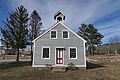
Bell School
Richmond Historical Society |
||
|
||
| Country | ||
| State | ||
| County | Washington | |
| Area | ||
| • Total | 40.8 sq mi (105.6 km2) | |
| • Land | 40.6 sq mi (105.0 km2) | |
| • Water | 0.2 sq mi (0.6 km2) | |
| Elevation | 381 ft (116 m) | |
| Population
(2020)
|
||
| • Total | 8,020 | |
| • Density | 198/sq mi (76.4/km2) | |
| Time zone | UTC−5 (Eastern (EST)) | |
| • Summer (DST) | UTC−4 (EDT) | |
| ZIP codes |
02812 (Carolina), 02832 (Hope Valley), 02836 (Kenyon), 02875 (Shannock), 02892 (West Kingston), 02894 (Wood River Junction), 02898 (Wyoming)
|
|
| Area code(s) | 401 | |
| FIPS code | 44-61160 | |
| GNIS feature ID | 1220089 | |
| Website | http://www.richmondri.com | |

Richmond is a town located in Washington County, Rhode Island, United States. In 2020, about 8,020 people lived there. Richmond is made up of several small communities, or villages. Some of these include Alton, Arcadia, Carolina, and Wyoming. Students living in Richmond attend schools within the Chariho Regional School District.
Contents
History of Richmond
How Richmond Became a Town
The area that is now Richmond was once part of Westerly, Rhode Island. This land was disputed for many years by different colonies. In 1665, King Charles II renamed the disputed area "King's County."
In May 1669, the Rhode Island government organized King's County into the town of Westerly. Westerly then divided itself into four parts: Westerly, Charlestown, Richmond, and Hopkinton. This is how Richmond got its start as a separate area. Later, King's County was renamed Washington County during the American Revolution.
The 1873 Bridge Accident
On April 19, 1873, a sad event happened in the village of Richmond Switch. This village is now known as Wood River Junction. A bridge there was washed away by water. A passenger train came along, and the people on board did not know the bridge was gone. The train went off the tracks and fell into the water. Eleven people lost their lives, and others were swept away by the water.
The Washington County Fair
Since 1970, Richmond has been home to the Washington County Fair. This fair is the biggest one in the entire state of Rhode Island. It's a popular event where people can enjoy rides, food, and various exhibits.
Geography of Richmond
Where is Richmond Located?
Richmond is about 35 miles (56 km) south of Providence, which is the capital city of Rhode Island. It is a town that is mostly covered by forests. Richmond is also a landlocked community, meaning it does not touch the ocean.
Land and Water Area
The town of Richmond covers a total area of about 40.8 square miles (106 km2). Most of this area is land, about 40.6 square miles (105 km2). Only a small part, about 0.2 square miles (0.52 km2), is water.
Neighboring Towns
Richmond shares its borders with several other towns. To the south, it borders Charlestown. To the north and northeast, it borders Exeter. To the west, it borders Hopkinton. Finally, to the southeast, it borders South Kingstown. Richmond is special because it's the only town in Washington County that doesn't border another county or the ocean.
Carolina Management Area
A large area of land in Richmond, about 2,359 acres (9.55 km2), is owned by the state. This area is called the Carolina Management Area. It is managed to help wildlife and provide food for animals. Most of this area, about 1,416 acres (5.73 km2), is forest. It also includes wetlands and land used for farming.
Population of Richmond
| Historical population | |||
|---|---|---|---|
| Census | Pop. | %± | |
| 1790 | 1,760 | — | |
| 1800 | 1,368 | −22.3% | |
| 1810 | 1,330 | −2.8% | |
| 1820 | 1,423 | 7.0% | |
| 1830 | 1,363 | −4.2% | |
| 1840 | 1,361 | −0.1% | |
| 1850 | 1,784 | 31.1% | |
| 1860 | 1,964 | 10.1% | |
| 1870 | 2,064 | 5.1% | |
| 1880 | 1,949 | −5.6% | |
| 1890 | 1,669 | −14.4% | |
| 1900 | 1,596 | −4.4% | |
| 1910 | 1,633 | 2.3% | |
| 1920 | 1,301 | −20.3% | |
| 1930 | 1,535 | 18.0% | |
| 1940 | 1,629 | 6.1% | |
| 1950 | 1,772 | 8.8% | |
| 1960 | 1,986 | 12.1% | |
| 1970 | 2,625 | 32.2% | |
| 1980 | 4,018 | 53.1% | |
| 1990 | 5,351 | 33.2% | |
| 2000 | 7,222 | 35.0% | |
| 2010 | 7,708 | 6.7% | |
| 2020 | 8,020 | 4.0% | |
| U.S. Decennial Census | |||
In 2000, there were 7,222 people living in Richmond. The town had 2,537 households, with many of them being families. About 40% of households had children under 18 living there. The average household had about 2.84 people.
The population was spread out by age. About 28% of the people were under 18 years old. The median age in Richmond was 36 years. This means half the people were younger than 36, and half were older.
The median income for a household in Richmond was about $59,840. This means half of the households earned more than this amount, and half earned less. A small number of families and people lived below the poverty line.
Famous People from Richmond
Richmond has been home to some notable individuals:
- Billy Gilman (born 1988) is a country music singer. He was also the runner-up on Season 11 of the TV show The Voice. Billy Gilman is from the village of Hope Valley.
- Thomas A. Tefft (1826–1859) was a talented architect.
- Frank J. Williams (born 1940) served as the Chief Justice of the Supreme Court of Rhode Island from 2001 to 2009.
Historic Places in Richmond
Several places in Richmond are listed on the National Register of Historic Places. These are important sites that help us remember the past. They include:
- Carolina Village Historic District
- John Hoxsie House
- Shannock Historic District
- Wyoming Village Historic District
Images for kids
-
Bell School, Richmond Historical Society
See also
 In Spanish: Richmond (Rhode Island) para niños
