
Gulf Breeze, Florida facts for kids
Quick facts for kids
Gulf Breeze, Florida
|
|
|---|---|
| City of Gulf Breeze | |

Entrance sign and median in Gulf Breeze, FL heading East on Hwy 98, July 2013
|
|

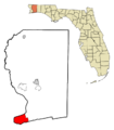
Location in Santa Rosa County and the state of Florida
|
|
| Country | |
| State | |
| County | Santa Rosa |
| Incorporated | August 10, 1961 |
| Government | |
| • Type | Council-Manager |
| Area | |
| • City | 22.14 sq mi (57.34 km2) |
| • Land | 4.68 sq mi (12.12 km2) |
| • Water | 17.46 sq mi (45.22 km2) |
| Elevation | 16 ft (5 m) |
| Population
(2020)
|
|
| • City | 6,340 |
| • Density | 1,354.70/sq mi (523.10/km2) |
| • Metro | 509,905 (Pensacola metropolitan area) |
| Time zone | UTC-6 (CST) |
| • Summer (DST) | UTC-5 (CDT) |
| ZIP codes |
32561, 32562, 32563
|
| Area code(s) | 850 |
| FIPS code | 12-28000 |
| GNIS feature ID | 283485 |
| Website | https://cityofgulfbreeze.us/ |
Gulf Breeze is a city in Santa Rosa County, Florida. It is located between Downtown Pensacola and Pensacola Beach. Gulf Breeze is part of the larger Pensacola metropolitan area. In 2020, about 6,340 people lived there.
Gulf Breeze is the closest city to Pensacola Beach. It provides important services to the island and much of South Santa Rosa County. Some nearby areas like Oriole Beach and Tiger Point are also considered part of Gulf Breeze for mailing addresses.
Contents
History of Gulf Breeze
The area we now call Gulf Breeze was first settled by the British in the mid-1700s. Its original name was Town Point. People used the strong wood from live oak trees in the area to build ships. Blacksmiths also set up shops to fix ships. During the Civil War, a camp and hospital for Confederate soldiers were located in the Deer Point area of Gulf Breeze.
In the late 1800s, a dry dock for ship repair was built on Deadman's Island. This island was once a major place for ships to stay in quarantine before entering Pensacola. The island got its name from "Deadman anchors." Later, a glue factory and a fertilizer plant were built on Deadman's Island.
Between 1928 and 1933, many roads were built in Gulf Breeze. The first bridge connecting Pensacola and Gulf Breeze was built by Johnson, Drake & Piper. The first paved road in Gulf Breeze was U.S. Highway 98, finished in 1933. A wooden swing bridge was built between Pensacola Beach and Gulf Breeze in 1931. This swing bridge was replaced by a concrete toll bridge in 1946. In 1973, that bridge became the Bob Sikes fishing pier.
The name Gulf Breeze comes from the Gulf Breeze Cottages and Store. This is where the area's first post office opened in 1936. The city officially became a city on August 10, 1961. This happened because the Pensacola Bay Bridge was expanding. Gulf Breeze also became well-known after the 1987 Gulf Breeze UFO Incident.
Geography and Climate
The city of Gulf Breeze covers about 23.56 square miles. About 4.68 square miles of this is land, and 18.88 square miles is water.
The city's growth is limited because it is surrounded by water on three sides. Also, the eastern part of Gulf Breeze has the Naval Live Oaks Reservation. Because of this, new buildings and growth happen mostly east of the city limits along U.S. Highway 98.
Weather in Gulf Breeze
| Weather chart for Gulf Breeze, FL | |||||||||||||||||||||||||||||||||||||||||||||||
|---|---|---|---|---|---|---|---|---|---|---|---|---|---|---|---|---|---|---|---|---|---|---|---|---|---|---|---|---|---|---|---|---|---|---|---|---|---|---|---|---|---|---|---|---|---|---|---|
| J | F | M | A | M | J | J | A | S | O | N | D | ||||||||||||||||||||||||||||||||||||
|
5.7
61
43
|
4.9
64
45
|
6.3
70
52
|
4
75
57
|
4.4
83
65
|
5.2
88
72
|
7.1
90
74
|
6.1
92
74
|
6.7
87
70
|
4.2
79
59
|
4.4
71
51
|
4
64
45
|
||||||||||||||||||||||||||||||||||||
| temperatures in °F precipitation totals in inches source: weather.com/NOAA.gov |
|||||||||||||||||||||||||||||||||||||||||||||||
|
Metric conversion
|
|||||||||||||||||||||||||||||||||||||||||||||||
People in Gulf Breeze
| Historical population | |||
|---|---|---|---|
| Census | Pop. | %± | |
| 1970 | 4,190 | — | |
| 1980 | 5,478 | 30.7% | |
| 1990 | 5,530 | 0.9% | |
| 2000 | 5,665 | 2.4% | |
| 2010 | 5,763 | 1.7% | |
| 2020 | 6,302 | 9.4% | |
| U.S. Decennial Census | |||
In 2020, there were 6,302 people living in Gulf Breeze. There were 2,983 households and 1,809 families.
Things to See and Do

In 1828, the U.S. government bought the land for the Naval Live Oaks Reservation. They wanted to grow live oak trees there. The wood from live oaks was very important for building ships before the Civil War. Protecting these trees was vital for the United States Navy. Today, this land is over 1,300 acres and is part of the Gulf Islands National Seashore. The National Park Service manages it. You can find a visitor center and public beaches south of Highway 98.
Gulf Breeze Library
| Gulf Breeze Library | |
|---|---|
| Established | 1971 |
| Location | Gulf Breeze, Florida |
| Coordinates | 30°21′21″N 87°10′18″W / 30.3558°N 87.1717°W |
| Branch of | Santa Rosa County Library System |
The Gulf Breeze Library opened in 1971. It is part of the Santa Rosa County Library System.
Education in Gulf Breeze
Gulf Breeze Academic Plaza
The Gulf Breeze Academic Plaza is a group of 14 school buildings. They are all located around US Highway 98 in Gulf Breeze. This plaza includes:
- Gulf Breeze High School
- Gulf Breeze Middle School
- Gulf Breeze Elementary School
The plaza also has sports fields like Dolphin Field at Gulf Breeze Stadium for football, soccer, and track. There is also Dolphin Stadium for baseball and Gulf Breeze Softball Stadium for softball.

Transportation
Gulf Breeze is served by route 61 of Escambia County Area Transit, which is a local bus service.
Famous People from Gulf Breeze
Many interesting people have lived in or are from Gulf Breeze:
- Bob Armstrong (1939–2020), a professional wrestler.
- Doug Baldwin (born 1988), an American football player.
- Ashley Brown (born 1982), a singer and actress.
- Ben Lively (born 1992), a baseball pitcher.
- Jason McKie (born 1980), an American football player.
- Frank Spellman (1922–2017), an Olympic champion in weightlifting.
- Abigail Spencer (born 1981), an actress who was born and grew up in Gulf Breeze.
- Adrian Street (born 1940), a professional wrestler.
Images for kids
-

Entrance sign and median in Gulf Breeze, FL heading East on Hwy 98, July 2013
-
Location in Santa Rosa County and the state of Florida
-
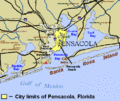
Map showing Gulf Breeze's location near Pensacola and Pensacola Beach.
-
Gulf Breeze High School
See also
 In Spanish: Gulf Breeze para niños
