Hamakua facts for kids

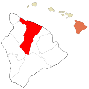
Hāmākua is a special area located on the northeast coast of Hawaiʻi's Big Island. It's managed by the local government of Hawaiʻi County in the state of Hawaiʻi. People also call the coastline in this area the "Hāmākua Coast."
Contents
Exploring the Hāmākua Coast
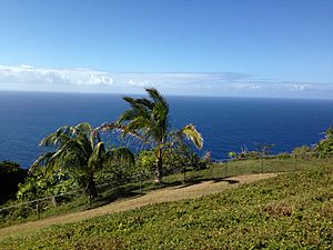
The Hāmākua Coast stretches for about 50 miles (80 km) along the Pacific Ocean. It ends at a beautiful place called Waipiʻo Valley and the empty Waimanu Valley. When people talk about the Hāmākua Coast, they usually mean the area between Hilo and Waipiʻo. However, the official Hāmākua district starts north of Laupāhoehoe and west of ʻŌʻōkala.
Nature and Landscape
The weather here is very rainy because of the trade winds that blow from the northeast. This rain has created steep valleys and cliffs over time, and you can see signs of landslides. The area is full of green plants and doesn't have many sandy beaches. This makes it look very different from other parts of the island.
The biggest natural feature in Hāmākua is the huge volcano Mauna Kea. The district also reaches south through a central flat area all the way to the top of Mauna Loa. Hāmākua was one of the six main areas of the island in ancient Hawaii (called moku). North of Waipiʻo Valley is the Kohala district, which has an even older volcano called Kohala mountain. The group Hui Mālama i ke Ala ʻŪlili says Hāmākua is famous for its "steep mountain trails."
A Look at Hāmākua's Past
In Hawaiian mythology, the snow goddess Poliʻahu was said to live on Mauna Kea. Many other legends also come from this special mountain.
Ranches and Sugar Plantations
In 1847, John Palmer Parker started the Parker Ranch on the high grassy lands of Mauna Kea. Over the years, especially with manager Alfred Wellington Carter, the ranch grew to cover much of the mountain's slopes.
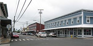
Many small towns grew up around the sugarcane plantations that operated along the Hāmākua Coast for most of the 20th century. The demand for sugar cane increased after the Reciprocity Treaty of 1875 made it cheaper to send sugar to the United States. The first sugar mill started working in 1876. Early investors included Claus Spreckles, Samuel Parker, and Theophilus Harris Davies. Many sugar companies, like Hāmākua Mill Company and Honokaʻa Sugar, eventually joined together to form the Hāmākua Sugar Company.
Changes in the Economy
Sugar plantations started to close down in the second half of the 20th century. After 1970, about 10% of the population left each decade. The Hāmākua Sugar Company had its last harvest in 1994. After many years of people not having jobs, the economy changed. Now, there are many small farms growing different crops. These crops include macadamia nuts, papaya, mango, coffee, and other tropical fruits. Old irrigation canals, built in 1910, were fixed in 2001 to help with farming.
Protecting Nature
Most of the original native forests below a certain height were cleared for growing sugarcane. However, some parts of the native forest still remain. In steep areas like gulches, where farming was too difficult, the original forest is still mostly untouched. There are also protected places like Kalōpā State Recreation Area, which keeps a small group of native trees safe. Other protected areas include several State Forest Reserves and Wildlife Refuges on Mauna Kea and Mauna Loa.
In 2009, the Mauna Kea Observatory was chosen as the location for a new Thirty Meter Telescope. Even though some local people were against it, others in the community liked the idea because it would bring new types of jobs and activities to the area.
Getting Around Hāmākua

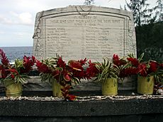
The Hawaii Consolidated Railway used to connect the Hāmākua sugar plantations to the harbor at Hilo Bay. But on April 1, 1946, a huge tsunami caused by an earthquake damaged the railroad so badly that it stopped running. Years later, the state of Hawaii took over the land. By 1960, they rebuilt the Hawaii Belt Road (Route 19), also known as the Māmalahoa Highway, to make driving faster.
In many places, the older highway (Old Māmalahoa Highway) takes a more winding but very scenic route. It's a bit like the famous Road to Hana on Maui.
Fun Places to Visit
Along the Māmalahoa Highway, you can find many popular spots for fun and relaxation. These include Akaka Falls, Umauma Falls, Hawaii Tropical Botanical Garden, World Botanical Gardens, and Kolekole Beach Park.
The Saddle Road (Route 200) goes from Hilo through the middle of the district. This road lets you reach the high plateau between Mauna Loa and Mauna Kea. It also leads to the amazing astronomical observatories on top of Mauna Kea and the NOAA observatory high up on Mauna Loa.
Towns and Villages in Hāmākua
Even though there are no officially separate cities in Hawaii, Hāmākua has several communities:
Famous People from Hāmākua
Some notable people who have lived in or are connected to Hāmākua include:
- David McHattie Forbes (1863–1937), a sugar planter from Scotland.
- Edward Griffin Hitchcock (1837–1898), a sugar planter and sheriff.
- Rufus Anderson Lyman (1842–1910), who started the Paʻauhau Sugar Plantation.
- Pablo Manlapit (1891–1969), a leader who helped organize workers.
- William Herbert Purvis (1858–1950), an English planter who brought Macadamia trees to Hawaii.
- Erik Hazelhoff Roelfzema (1917–2007), a Dutch spy and author.
- Dwight Takamine (born 1953), who became a state senator.
- Georges Phillipe Trousseau (1833–1894), a French doctor for the Hawaiian royal family.
- John D. Waihee III (born 1946), who was the first native Hawaiian governor.
- Roseanne Barr (born 1952), a well-known American actress and comedian.
 | Madam C. J. Walker |
 | Janet Emerson Bashen |
 | Annie Turnbo Malone |
 | Maggie L. Walker |


