Hardyston Township, New Jersey facts for kids
Quick facts for kids
Hardyston Township, New Jersey
|
||
|---|---|---|
|
Township
|
||
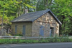
Old Monroe School House
|
||
|
||
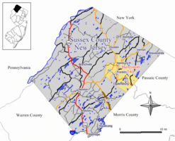
Map of Hardyston Township in Sussex County. Inset: Location of Sussex County highlighted in the State of New Jersey.
|
||
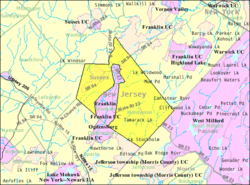
Census Bureau map of Hardyston Township, New Jersey
|
||
| Country | ||
| State | ||
| County | ||
| Royal charter | February 25, 1762 | |
| Incorporated | February 21, 1798 | |
| Named for | Josiah Hardy | |
| Government | ||
| • Type | Special charter | |
| • Body | Township Council | |
| Area | ||
| • Total | 32.65 sq mi (84.56 km2) | |
| • Land | 31.99 sq mi (82.84 km2) | |
| • Water | 0.66 sq mi (1.72 km2) 2.03% | |
| Area rank | 74th of 565 in state 7th of 24 in county |
|
| Elevation | 1,070 ft (330 m) | |
| Population
(2020)
|
||
| • Total | 8,125 | |
| • Estimate
(2023)
|
8,409 | |
| • Rank | 289th of 565 in state 6th of 24 in county |
|
| • Density | 254.0/sq mi (98.1/km2) | |
| • Density rank | 489th of 565 in state 14th of 24 in county |
|
| Time zone | UTC−05:00 (Eastern (EST)) | |
| • Summer (DST) | UTC−04:00 (Eastern (EDT)) | |
| ZIP Code | ||
| Area code(s) | 973 | |
| FIPS code | 3403729850 | |
| GNIS feature ID | 0882269 | |
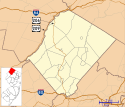
Hardyston Township is a community in Sussex County, New Jersey. It is a type of local government known as a township. In 2020, about 8,125 people lived here.
Contents
History of Hardyston Township
Hardyston Township has a long and interesting history. It was officially created on February 25, 1762. This happened through a special document called a Royal charter, which was like a permission slip from the King of England.
How Hardyston Got Its Name
The township was named after Josiah Hardy. He was the royal governor of New Jersey from 1761 to 1763. At first, the name was spelled "Hardiston." After the American Revolutionary War, people changed the spelling to "Hardyston."
Becoming an Official Township
On February 21, 1798, Hardyston became one of New Jersey's first 104 official townships. Over time, parts of Hardyston were used to create other towns. These include Vernon Township (in 1793), Sparta (in 1845), Franklin (in 1913), and Hamburg (in 1920).
Railroad and Transportation History
Hardyston was once served by trains. The New Jersey Midland Railway built a station in Stockholm. This area was first called Snufftown because of a snuff factory nearby. Later, the name changed to Stockholm.
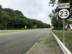
The New York, Susquehanna and Western Railway also provided train service until the early 1960s. Today, this railway still carries freight through Hardyston. The main roads that run through the township are Route 23 and Route 94.
Newark's Water Supply
A large part of eastern Hardyston Township is owned by the City of Newark. This land is part of the Pequannock River Watershed. It's a huge area of about 35,000 acres that helps provide drinking water to Newark.
Historic Cemeteries in Hardyston
Hardyston Township is home to the North Church Cemetery, also known as North Hardyston Cemetery. Several important historical figures are buried here:
- Samuel Fowler (1779–1844): He served in the U.S. House of Representatives from 1833 to 1837.
- Samuel Fowler (1851–1919): He also represented New Jersey in the U.S. House of Representatives from 1893 to 1895.
- Daniel Haines: He was the 14th Governor of New Jersey for two terms (1843–1845 and 1848–1851).
- John Linn: He was a U.S. Representative from New Jersey from 1817 to 1821.
Geography and Natural Features
Hardyston Township covers about 32.65 square miles. Most of this is land, with a small amount of water.
Local Communities and Places
Many small communities and places are found within Hardyston Township. Some of these include Beaver Lake, Stockholm, Silver Lake, and Rudeville. You might also find parts of Hardyston in different ZIP Code areas, like 07460 (Stockholm) or 07419 (Hamburg).
Neighboring Towns
Hardyston Township shares borders with several other towns. In Sussex County, it borders Franklin, Hamburg, Lafayette Township, Ogdensburg, Sparta, Vernon Township, and Wantage Township. It also borders Jefferson Township in Morris County and West Milford in Passaic County.
Mountains and Rivers
Hardyston is a beautiful area with interesting natural features. Most of the township is part of the New York – New Jersey Highlands. This region has mountains like Hamburg Mountain and Pochuck Mountain. The western part of the township is in the Ridge-and-valley Appalachians. The Wallkill River flows through this area, heading northeast into New York state.
Education in Hardyston Township
Students in Hardyston Township attend public schools run by the Hardyston Township School District.
Local Schools
The district has two schools for younger students. Hardyston Township School serves students from pre-kindergarten through 5th grade. Hardyston Middle School is for students in grades 6 to 8. In the 2020–2021 school year, there were about 593 students in these schools.
High School Education
For high school, students from Hardyston Township go to Wallkill Valley Regional High School. This high school also serves students from Franklin, Hamburg, and Ogdensburg. It had about 590 students in the 2020–2021 school year. Hardyston Township has four representatives on the high school's board of education.
Transportation Routes
Hardyston Township has many miles of roads for travel. In 2010, there were about 63.53 miles of roadways. Most of these roads are maintained by the township itself.
The main highways that serve Hardyston Township are Route 23 and Route 94. Other important roads include County Route 515 and County Route 517.
Local Wineries
Hardyston Township is home to Cava Winery & Vineyard.
Notable People from Hardyston
Many interesting people have connections to Hardyston Township. These are people who were born there, lived there, or are closely linked to the community:
- A. L. A. Himmelwright (1865–1936): He was a civil engineer, writer, and adventurer. He was also the general manager of The Roebling Construction Company.
- Christopher Sieber (born 1969): He is an actor known for his roles in TV shows like Two of a Kind and Broadway musicals like Shrek the Musical, where he played Lord Farquaad.
See also
 In Spanish: Municipio de Hardyston para niños


