
Harefield, Southampton facts for kids
Quick facts for kids Harefield |
|
|---|---|
 Cheriton Avenue, Harefield |
|

Harefield
|
|
| Area | 2.62 km2 (1.01 sq mi) |
| Population | 14,488 |
| • Density | 5,530/km2 (14,300/sq mi) |
| Unitary authority | |
| Ceremonial county | |
| Region | |
| Country | England |
| Sovereign state | United Kingdom |
| Post town | SOUTHAMPTON |
| Postcode district | SO18 |
| Dialling code | 023 |
| Police | Hampshire |
| Fire | Hampshire |
| Ambulance | South Central |
| EU Parliament | South East England |
| UK Parliament | |
Harefield is a friendly area, also known as a ward, located near Bitterne in Southampton, England. A ward is like a local district that elects its own representatives to the city council. Harefield Ward includes a housing area with homes built by the local council around 1952-1953. This area was built on a large piece of land that used to be part of the Harefield House estate. There are also many private homes in Harefield.
In 2021, the Harefield Ward had about 14,448 people living there. It's next to other wards like Bitterne Park, Peartree, Sholing, and Bitterne.
Contents
Harefield's Past: A Look at Its History
The Story of Harefield House
The original Harefield House was a large country home built in 1834. It was made in the style of Elizabethan buildings, which means it looked a bit like castles or grand homes from the time of Queen Elizabeth I. A man named Sir Edward Butler, who was in charge of a railway company, had it built. Today, the land where this house stood is where Harefield Infant and Junior Schools are located on Yeovil Chase.
Later, in 1887, a shop owner from Southampton named Edwin Jones bought the house. His shop eventually became part of the famous Debenhams stores. Many people thought Harefield House burned down in 1915, but this was a mistake! It actually burned down on May 6, 1917. This was reported in the local newspaper, the Southern Daily Echo, the very next day.
After the fire, the Jones family sold the estate in 1917. Some building happened in the 1920s, but the area really started to grow and develop after the Second World War.
How Harefield Became Part of Southampton
For a while, Harefield was part of a nearby area called West End. But in 1954, it officially became part of Southampton.
Street Names and Local Development
If you look at the street names on the western side of Harefield, you'll notice they are all named after places in Somerset, another county in England. Private builders chose these names when they started building homes there in the late 1940s and early 1950s. As more council homes were built, they extended these streets and added new ones to the west, which were named after villages in Hampshire.
When the housing area was built, it included important community places. There were two pubs (the Exford Arms and the Hare and Hounds), two shopping areas, and two primary schools (Harefield and Moorhill). Each primary school had separate sections for younger children (infants) and older children (juniors). A secondary school, Moorhill Secondary School, was also built. It was named after Moorhill House, which was just outside Harefield.
The Moorhill schools and one of the shopping areas (on Exford Avenue) were built in 1964-1965. Before that, there was even a Post Office in a special hut called a Nissen hut across from the Exford Arms!
Moorhill Secondary School changed its name to Woodlands Community School in 1984. The old school building was taken down and a new one was built in 2003. Today, it's known as Woodlands Community College.
Getting Around Harefield: Transport Links
Over the years, Harefield has had different local bus services. Right now, the main bus service is the number 13 First Bus. This bus can take you to Bitterne, Woolston, and the City Centre. However, this bus service does not run on Sundays.
Art in the Community: Public Art in Harefield
Harefield is also known for its cool public art! One special project is called the Mosaic Way. This is a trail of permanent mosaics that were created by people who live in the area. These beautiful artworks were put in place in 2021, making the community even more vibrant.
Images for kids
-
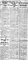
A newspaper clipping from the Southern Daily Echo reporting the fire at Harefield House on May 7, 1917.

