Bitterne facts for kids
Quick facts for kids Bitterne |
|
|---|---|
| Suburb | |
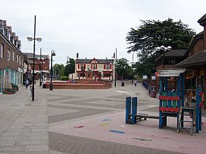 The pedestrianised area of Bitterne Road is a popular shopping precinct. This is the old junction of the Hedge End and Portsmouth Roads looking east. |
|
| Area | 2.47 km2 (0.95 sq mi) |
| Population | 13,800 (2011 Census. Ward) |
| • Density | 5,587/km2 (14,470/sq mi) |
| OS grid reference | SU451129 |
| Unitary authority | |
| Ceremonial county | |
| Region | |
| Country | England |
| Sovereign state | United Kingdom |
| Post town | SOUTHAMPTON |
| Postcode district | SO18 |
| Dialling code | 023 |
| Police | Hampshire |
| Fire | Hampshire |
| Ambulance | South Central |
| EU Parliament | South East England |
| UK Parliament | |
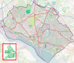
Bitterne is a lively area located in the eastern part of Southampton, England. It is also a special voting area, called a ward. Bitterne is part of the larger county of Hampshire.
The name Bitterne does not come from the bird called a bittern. Instead, it likely comes from old English words. Byht and ærn together mean "house near a bend." This might refer to a bend in the River Itchen. Another idea is bita ærn, meaning "house of horse bits." The name was spelled Byterne in the late 11th century.
The area known as Bitterne Ward includes Bitterne and a nearby place called Thornhill. In 2011, about 13,800 people lived here. This ward is next to Sholing Ward and Harefield Ward.
Contents
History
Today, the main part of Bitterne is where the old Bitterne Village used to be. But even before the village, there was a settlement at Bitterne Manor. This was the site of an ancient Roman town called Clausentum. This Roman town was the beginning of what is now the city of Southampton.
Bitterne is not mentioned in the famous Domesday Book. It first appears in records from the late 11th century. These records from the Bishop of Winchester call it Byterne. However, this record was about Bitterne Manor, not the village we know today.
In 1665, only about 75 people lived in Bitterne. They lived in 15 houses, including Bitterne Manor House.
A new estate called Bitterne Grove was built in 1760. Today, this is where St Mary's Independent School is located. Workers' cottages were also built to support the estates. These cottages were in an area of Bitterne called Mousehole. In the 1790s, the royal family often visited Southampton. This made people want to buy land in the area. More estates were added, like Ridgeway and Midanbury Lodge.
Around this time, Townhill Park House was also built. Chessel House was built in 1796 by David Lance. Mr. Lance knew that it was hard to get to his land. So, he helped build a bridge over the River Itchen. This bridge connected Bitterne Manor to Northam. Another bridge was built over the River Hamble at Bursledon. A new road linked these bridges. This road met another new road, to Botley, at the spot that is now the center of Bitterne.
Building these new roads and bridges finished in 1801. This new road junction helped Bitterne Village grow. However, in 1826, records still only mentioned the large estates, not a small village.
By the 1900s, Bitterne Village became part of the quickly growing city of Southampton. In the 1950s, Bitterne was changed a lot. Old Victorian cottages were replaced with new buildings and housing estates. For example, the Angel pub was replaced by Sainsbury's supermarket.
In the 1980s, a new road was built to help traffic flow better. This road, the A3024, went around the main high street. This allowed the old high street to become a pedestrian area. Now, people can walk and shop safely without cars.
Geography
It can be tricky to say exactly where Bitterne begins and ends. However, the Bitterne ward, which includes Thornhill, covers about 2.47 square kilometers. This area is mostly suburban, meaning it has many houses and shops. It is about 3.5 kilometers northeast of the Bargate in Southampton City Centre.
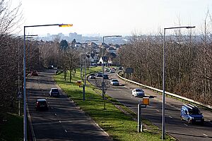
Bitterne is located on a raised area of land. This gives it great views over much of the city. The road leading up this hill is called Lance's Hill. It was named after David Lance, who helped build the Northam Bridge. This bridge connects Bitterne to central Southampton.
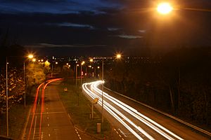
Today, the main road, the A3024 road, goes around the central shopping area. This part of the road has two lanes in each direction. Because the Northam Bridge is the only free bridge into Southampton from the east, this road can get very busy. The old section of the road is now a pedestrian area. This makes it a popular place for shopping.
Demography
In 2011, Bitterne Ward had a population of 13,800 people. About 22.3% of these people were under 15 years old. About 61.1% were of working age, and 16.6% were 65 or older. Bitterne has a slightly higher number of younger and older people compared to Southampton as a whole. The number of people in all age groups has grown since 2001.
Most people in Bitterne are white British, making up 91.1% of the population. No other ethnic group makes up more than 2.6% of the people. Bitterne has one of the highest percentages of white British people in Southampton.
In 2011, 54.5% of people in Bitterne said they were Christian. About 35.9% said they had no religion. The next largest religious group was Muslims, making up 1.3% of the population.
Economy
Bitterne does not have many large factories or industrial areas. So, most jobs in Bitterne are in the service industry. This means jobs are often in shops and other businesses that help people.
Besides the shops in the main shopping area, Bitterne also has a weekly street market. This market was approved by the city council in 2009. It started as a trial in 2008 and was very successful.
Community facilities
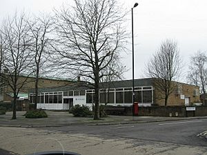
Bitterne Library is one of the biggest libraries in Southampton. Many activities happen there regularly. These include reading groups, an IT club, a job club, and a family history group. There is also a local history society that has published books. They also run a charity shop and museum.
Bitterne Leisure Centre is managed by Active Nation, a sports charity. It offers many activities like swimming, exercise classes, and badminton. There is also a gym above Sainsbury's supermarket. This spot used to be a ten-pin bowling center called "Bitterne Bowl." It moved to Eastleigh in 2008.
Between the library and the leisure center is Bitterne Health Centre. It has a GP surgery (doctor's office) and an emergency dental service. There are also other doctor's offices in the area.
Transport
Bitterne is located where the A334 and A3024 roads meet. This makes it easy to get to the M27 motorway to the east. It is also easy to reach Southampton City Centre to the southwest. Because of this, many bus routes serve Bitterne. Bus companies like Bluestar and Xelabus operate here.
Bitterne railway station is about 1.2 kilometers west of the shopping area. It is on the West Coastway Line.
Bus Routes: 3, 13, 14, 16, 18 ( Bluestar )
Education
Bitterne has several primary schools. These include Bitterne's Church of England Primary school, Glenfield Infant School, and Beechwood Junior School.
There are no public secondary schools right in Bitterne. However, nearby schools serve the area well. These include Bitterne Park School, Woodlands Community College, and Sholing Technology College. They are all within walking distance. For further education, Itchen College offers many courses.
Primary School
- Beechwood Junior School
- Bitterne C&E Primary School
- Glenfield Infant School
- Bitterne Park Primary School
Secondary School/Sixth Form College
- Bitterne Park School
Religious sites
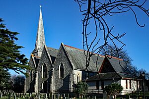
Bitterne's main church is called Holy Saviour. Its tall spire is a well-known landmark in the area. This church is a partnership between Anglican and Methodist groups. They joined together after the Methodist church building was sold. It is a Grade II listed building, meaning it is historically important.
Bitterne United Reformed Church is at the top of the pedestrian shopping area. It is next to the Holy Saviour church. This church is on the first floor of its building, with shops underneath. Currently, an Iceland supermarket is in the retail space.
The Christ the King Roman Catholic Church is another local landmark. It is on the main A3024 road, between the health center and the library. Bitterne Spiritualist Church was started in 1947. It is located at the top of Lances Hill.
 | Sharif Bey |
 | Hale Woodruff |
 | Richmond Barthé |
 | Purvis Young |


