Sholing facts for kids
Quick facts for kids Sholing |
|
|---|---|
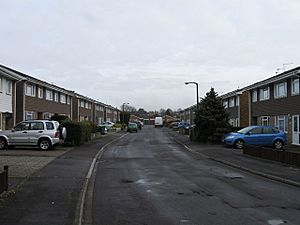 Kenson Gardens, a typical Sholing street |
|
| Area | 2.95 km2 (1.14 sq mi) |
| Population | 14,053 |
| • Density | 4,764/km2 (12,340/sq mi) |
| Unitary authority | |
| Ceremonial county | |
| Region | |
| Country | England |
| Sovereign state | United Kingdom |
| Post town | SOUTHAMPTON |
| Postcode district | SO19 |
| Dialling code | 023 |
| Police | Hampshire |
| Fire | Hampshire |
| Ambulance | South Central |
| EU Parliament | South East England |
| UK Parliament | |
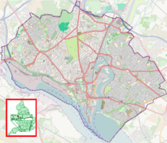
Sholing is a lively area on the eastern side of Southampton in Southern England. It sits between the areas of Bitterne, Thornhill, and Woolston.
The name "Sholing" might come from an old Anglo-Saxon phrase. Many people think it means "hill on the shore." This makes sense because Sholing is on high ground that slopes down towards Southampton Water.
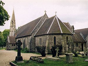
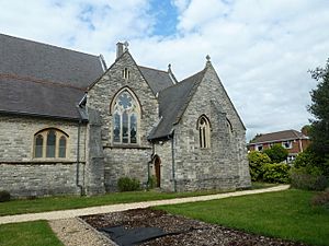
Sholing's main church, St Mary's, opened in 1866. In 1920, Sholing became part of the larger town of Southampton. The area also has a railway station, which opened in 1866. It connects Sholing to Southampton and Portsmouth.
Contents
Discover Sholing's Past
What's in a Name? The Meaning of Sholing
The name 'Sholing' has a few possible meanings. On older maps, it was spelled 'Scholing'. One idea is that it means 'the hill above the shore' or 'the hill sloping down to the shore'. This fits, as Sholing is on high ground that goes down towards the water.
Another idea is that the 'ing' part of the name means an area where the children of a person named "Schol" lived. In Old English, 'Scēolingas' could mean 'people connected to someone called Scēolh'. This was a nickname for someone who might have been crooked or squint-eyed.
There's also a local Romany explanation. It suggests the name came from the heather plant called 'ling'. People might have said the area had a 'nice show o' ling'.
Spike Island: A Local Nickname
Some people locally call the area 'Spike Island'. There are a few stories about why. One is that it comes from the spiky gorse bushes that grow there. Another story links it to spikes used to hold chains for prisoners. These prisoners were supposedly held in the area before being sent to Australia.
Some people connect this name to Spike Island, County Cork in Ireland. That island was used to hold rebels and send people to Australia. This idea mixes with the name 'Botany Bay', which is also used locally. 'Botany Bay' just means a remote or hard-to-reach place, like its famous Australian namesake.
Early Days: From Ancient Times to Villages
Bronze tools have been found east of the River Itchen. There are also many ancient burial mounds in the area. Sholing was first mentioned in 1251. At that time, King Henry III gave it to the Abbot of Netley Abbey.
In the past, Sholing was a wilder place, mostly covered in gorse and heather. It was part of the Parish of Hound. In the late 1700s and early 1800s, Sholing Common was used as a place for soldiers to wait before going to war with France. You can still see reminders of this in local road names like Butts Road and Shooters Hill Close. Even a local pub is called 'The Target'!
How Sholing Grew
Sholing wasn't really a village at first. It was more like a small group of cottages built in the 1790s. The first people living there were often from Romany families. They kept their caravans and formed a close community. These families would live in houses in winter and travel in summer to pick hops or fruit.
The area started to change when the Floating Bridges opened in 1836. This made it easier to cross the River Itchen. Also, Southampton Docks were built in 1840. These changes made Sholing much more connected to Southampton.
When Netley Hospital opened in 1863, many staff members needed homes. They came to live in Sholing, along with people who worked for the wealthy families. New buildings and roads began to spread.
Local Life and Industries
In those days, the main jobs in Sholing were making bricks, digging wells, and growing strawberries. There were six brickyards in the area. At night, you could see the fires glowing from the kilns. Many people also worked as servants, or on ships in the docks. Their wives often took in laundry. Donkeys were a common way to get around for laundries and sellers. This led to another nickname for the area: 'Donkey Common'!
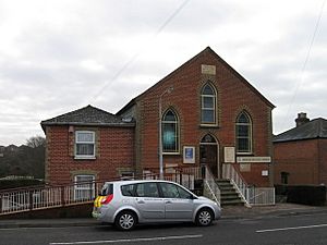
The first church, St Mary's, was built in 1866. Before that, a Primitive Methodist Chapel was built in 1856. This showed how popular the Methodists were with the working-class people of Sholing.
Schools for Growing Minds
Education improved over time. A National School for Girls and Infants was built in 1871. By then, Sholing had 1,444 people. New buildings for boys were added in 1885. Sholing Infants School opened in 1911. Over the years, schools moved and new ones were built. A new Junior School opened in St Monica Road in 1977.
Sholing in the 20th Century
Around 1900, Sholing was surrounded by five toll gates. This made it a bit isolated. The only way out without paying a toll was a longer journey through Bitterne.
However, in 1920, Sholing became part of the Borough of Southampton. This brought big changes to the area.
The Railway's Impact
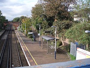
A small railway station opened in 1866. It had a single line, which was doubled in 1910. This station was very helpful for local strawberry growers, gardeners, and brick makers. It helped the area to grow and prosper. For example, Mr Darley's basket works made baskets for fruit growers.
The railway line connected Southampton to Fareham and Portsmouth. This made trading much easier. Sholing Station has been unstaffed since 1965. In 1990, the old station buildings were taken down and replaced with a simple waiting shelter.
World War II and After
Sholing didn't suffer too much damage during World War II. However, some houses were hit. A train near Sholing also got a direct hit. Sholing was also hit by Southampton's first flying bomb in 1944. Luckily, no one died from that attack.
After the war, many new council homes were built. This was needed because many parts of Southampton were destroyed by bombings. Former gravel pits, brickyards, and gardens became large residential areas.
Modern Schools and Colleges
A new Sholing Girls School started being built in 1938. But due to the war, it didn't open until 1945. This school became a specialist College of Technology in 2003. It uses advanced computer technology for learning.
Middle Road is also home to Itchen College. It started in 1906 as a teacher training center. It moved to its current site in 1921. During World War II, the school buildings were used for medical services. Itchen College is now a well-known college.
Miller's Pond: A Green Space
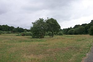
In 1961, there were plans to build many houses and shops around Miller's Pond. But these plans never happened. Today, Miller's Pond is a beautiful green space. It is home to the Sholing Valley Study Centre. This group helps protect the local wildlife. The area became a Local Nature Reserve in 2011.
Sholing has many local shops and restaurants. These include Tesco Express, Co-operative Food, and various take-away places.
Sports and Fun in Sholing
Sholing F.C. is the local football team. They have been playing since 1894! They used to be called Thornycrofts (Woolston) FC. Then they were Vosper Thornycroft FC (VTFC). In 2010, they changed their name to Sholing FC. Their nickname is The Boatmen. In 2014, Sholing F.C. even made it to the final of the FA Carlsberg Vase at Wembley Stadium!
Sholing in Books
James Brown wrote a book called The Illustrated History of Southampton's Suburbs. Here's a small part from it about Sholing:
Traces of its original rural nature have been retained through the network of Greenways established by the City Council since 1983. The three and a half-mile long Shoreburs Greenway, from Weston Shore to Bursledon Road, runs through Sholing, with two routes linking at Miller's Pond, now a local nature reserve and managed by a local community group. One runs between Middle Road and North-east Road, and the other between Kathleen Road and Butts Road. They are 'ribbons of open space which follow stream valleys' and preserve wildlife habitats. Sholing is fortunate to have these reminders of its rural past and long may they be retained.
This means that Sholing still has green spaces. These "Greenways" are like long paths that follow stream valleys. They help keep wildlife safe and remind people of Sholing's countryside past.
Important Dates in Sholing's History
- c. 6000 BC: The Ice Age ends. Britain is cut off from Europe by floods. The Sholing Valleys become a large marshy area.
- 50 AD: The Romans build Clausentum (Bitterne). A Roman road might have run through what is now Sholing.
- 495 AD: Cerdic, a Jutish prince, lands nearby. His kingdom will one day become England.
- c. 500 AD: Cerdic takes Clausentum, which is then left empty.
- c. 510 AD: The royal estate of Hamtun (Southampton) is likely founded.
- 534 AD: Cerdic dies. His lands become Hamtunscir (Hampshire).
- 980 AD: Vikings attack Southampton. The town slowly moves to its modern location.
- c. 990 AD: Vikings settle at Ulfston (Woolston).
- 1086 AD: The Domesday Book mentions settlements at Olvestune (Woolston) and Latelei (Netley).
- c. 1300 AD: Weston Mill probably starts. Miller's Pond gets its name from this mill.
- 1537 AD: King Henry VIII closes Netley Abbey.
- 1610 AD: A map shows a flooded valley surrounded by marshland.
- 1770 AD: First official mention of the mill at Weston. It made parts for ships, including HMS Victory.
- 1781 AD: The mill moves upstream to Woodmill because the stream wasn't powerful enough.
- 1791 AD: Another map shows the area almost empty.
- 1821 AD: The villages of Bitterne, Sholing, and Woolston become part of Southampton.
- 1839–40 AD: Southampton Docks and the railway to London are built. Southampton and Sholing start to grow quickly.
- 1866 AD: Sholing Station opens. Portsmouth Road is slightly moved. Miller's Pond gets smaller due to a new railway bank.
- 1867 AD: Sholing Church (St. Mary's) is built. Sholing becomes its own parish.
- 1871 AD: A survey shows 1,444 people live in Sholing.
- 1875 AD: Maps show an alternative spelling: Scholing.
- 1889 AD: The railway is extended to Fareham and Portsmouth.
- 1890 AD: First mention of the brickyard on Brickyard Hill.
- 1930s: Sholing Brick Company stops working.
- 1940 AD: During the Battle of Britain, Sholing is bombed.
- 1975 AD: The Southampton Model Railway Society, based at Sholing Station, faces high rent increases.
- 1977 AD: Itchen Toll Bridge opens, replacing the old floating bridge. This gives direct road access to the city centre.
- 1978 AD: Miller's Pond is partly restored.
- 1983 AD: Work begins on the "Shoreburs Greenway," connecting valleys to a footpath.
- 1988 AD: Sholing Valleys Study Centre opens. British Rail removes the old station buildings.
- 1993 AD: Sholing Sports FC has to close.
- 2005 AD: Sholing Station Post Office closes.
- 2008 AD: Both remaining post offices close.
- 2010 AD: Vosper Thornycroft F.C. changes its name to Sholing F.C..
- 2014 AD: Sholing F.C. reaches the FA Carlsberg Vase final at Wembley.
 | Selma Burke |
 | Pauline Powell Burns |
 | Frederick J. Brown |
 | Robert Blackburn |


