
Haverhill, New Hampshire facts for kids
Quick facts for kids
Haverhill, New Hampshire
|
||
|---|---|---|
|
Town
|
||

Haverhill municipal offices
|
||
|
||

Location in Grafton County, New Hampshire
|
||
| Country | United States | |
| State | New Hampshire | |
| County | Grafton | |
| Incorporated | 1763 | |
| Villages |
|
|
| Area | ||
| • Total | 52.4 sq mi (135.6 km2) | |
| • Land | 51.0 sq mi (132.1 km2) | |
| • Water | 1.4 sq mi (3.5 km2) 2.62% | |
| Elevation | 640 ft (200 m) | |
| Population
(2020)
|
||
| • Total | 4,585 | |
| • Density | 90/sq mi (34.7/km2) | |
| Time zone | UTC-5 (EST) | |
| • Summer (DST) | UTC-4 (EDT) | |
| ZIP codes | ||
| Area code(s) | 603 | |
| FIPS code | 33-34820 | |
| GNIS feature ID | 0873621 | |

Haverhill is a town in New Hampshire, located in the United States. It is the main town, or seat, of Grafton County. In 2020, about 4,585 people lived here.
Haverhill is made up of several smaller communities called villages. These include Woodsville, Pike, and North Haverhill. You can also find the historic town center at Haverhill Corner and the area known as Mountain Lakes.
The town is home to beautiful natural spots like Bedell Bridge State Park, Black Mountain State Forest, and Oliverian Valley Wildlife Preserve. Every year, the fun North Haverhill Fair takes place here. Haverhill also has a part of the New Hampshire Community Technical Colleges, which helps people learn new skills.
Contents
History of Haverhill
Haverhill was first settled by people from a town called Haverhill, Massachusetts. The area was originally known as "Lower Cohos." This name came from the Abenaki people, who were Native Americans who used this land for farming.
In 1763, Haverhill officially became a town. This was approved by the colonial Governor Benning Wentworth. By 1773, it was chosen as the county seat for Grafton County. This meant it became the main place for county government.
Haverhill was also the end point of an old road called the Province Road. This road connected northern and western settlements to the seacoast. By 1859, Haverhill had about 2,405 people. The town had many businesses, including mills for grinding grain and cutting wood. There were also factories that made paper, leather, carriages, and shoes.
One special landmark in Haverhill is the Haverhill–Bath Covered Bridge. It was built in 1829 and is the oldest covered bridge in the country that is still standing.
Villages and Their Stories
The village of Woodsville got its name from John L. Woods. He ran a sawmill and helped develop the railroad system in the area. Woodsville became an important center for railroads.
Another village, Pike, was settled by workers of the Pike Manufacturing Company. This company was famous for making whetstones, which are tools used to sharpen knives. At one point, it was the biggest whetstone maker in the world!
Even though Haverhill Corner was once the main part of town, the town's offices are now in North Haverhill. The county offices and courthouse are also nearby. Woodsville is now the main shopping and business area for Haverhill and nearby towns. It has supermarkets, banks, and restaurants. The town's schools and Cottage Hospital are also located in Woodsville.
Geography of Haverhill
Haverhill is located in the northwestern part of New Hampshire. The town covers about 135.6 square kilometers (about 52.3 square miles). Most of this area is land, with a small part being water.
The Connecticut River forms the western border of Haverhill. This river also separates New Hampshire from Vermont. Other important waterways in Haverhill include the Ammonoosuc River, Oliverian Brook, and Clark Brook. All these rivers and brooks flow into the Connecticut River.
The highest point in Haverhill is on the side of Black Mountain. This spot is about 2,320 feet (707 meters) above sea level. The very top of Black Mountain is in the next town over, Benton.
Roads and Travel
Several state roads help people travel through Haverhill. New Hampshire Route 10 runs north and south, following the Connecticut River. U.S. Route 302 comes from Vermont and goes through Woodsville. It then joins Route 10 to head northeast.
Other routes like New Hampshire Route 25, New Hampshire Route 116, and New Hampshire Route 135 also serve the town. Haverhill also has easy ways to get to U.S. Route 5 in Vermont using bridges.
Population Information
| Historical population | |||
|---|---|---|---|
| Census | Pop. | %± | |
| 1790 | 552 | — | |
| 1800 | 805 | 45.8% | |
| 1810 | 1,105 | 37.3% | |
| 1820 | 1,609 | 45.6% | |
| 1830 | 2,183 | 35.7% | |
| 1840 | 2,675 | 22.5% | |
| 1850 | 2,405 | −10.1% | |
| 1860 | 2,291 | −4.7% | |
| 1870 | 2,271 | −0.9% | |
| 1880 | 2,455 | 8.1% | |
| 1890 | 2,545 | 3.7% | |
| 1900 | 3,414 | 34.1% | |
| 1910 | 3,498 | 2.5% | |
| 1920 | 3,406 | −2.6% | |
| 1930 | 3,665 | 7.6% | |
| 1940 | 3,487 | −4.9% | |
| 1950 | 3,357 | −3.7% | |
| 1960 | 3,127 | −6.9% | |
| 1970 | 3,090 | −1.2% | |
| 1980 | 3,445 | 11.5% | |
| 1990 | 4,164 | 20.9% | |
| 2000 | 4,416 | 6.1% | |
| 2010 | 4,697 | 6.4% | |
| 2020 | 4,585 | −2.4% | |
| U.S. Decennial Census | |||
In 2010, there were 4,697 people living in Haverhill. There were 1,928 households, which are groups of people living together. About 26.2% of these households had children under 18.
Most of the people in Haverhill were white (96.7%). A small number of people were from other racial backgrounds. About 1.3% of the population identified as Hispanic or Latino.
The average age of people in Haverhill was 45 years old. About 19.4% of the population was under 18 years old.
Fun Places to Visit
- Bedell Bridge State Park
- Haverhill-Bath Covered Bridge (built in 1829)
- Haverhill Historical Society & Museum (learn about the town's past!)
- Museum of American Weather
- Oliverian School
- Clement Farm Disc Golf Course
Famous People From Haverhill
Many interesting people have connections to Haverhill:
- George Barstow (1824–1883), a politician from California.
- Samuel Brooks (around 1793–1849), a merchant and politician in Canada.
- Noah Davis (1818–1902), who was a U.S. congressman and judge.
- Henry W. Keyes (1863–1938), who served as the 56th governor of New Hampshire.
- Ebenezer Mackintosh (1737–1816), a leader in Boston during the Stamp Act protests.
- Thomas Leverett Nelson (1827–1897), a judge.
- John Page (1787–1865), who was a governor of New Hampshire and a U.S. senator.
- John A. Page (1814–1891), the son of Governor John Page, who became the Vermont State Treasurer.
- Chad Paronto (born 1975), a baseball pitcher for teams like the Baltimore Orioles and Atlanta Braves.
- Jonathan H. Rowell (1833–1908), a U.S. congressman from Illinois.
- Bob Smith (1931–2013), a baseball pitcher for teams like the Boston Red Sox.
- Mark Steyn (born 1959), a writer and political commentator.
- Frank Stoddard, a crew chief in NASCAR racing.
Images for kids
-
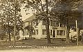
Green Door Inn around 1920
-
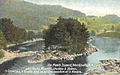
No Man's Island in 1913
-
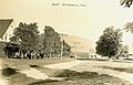
East Haverhill in 1917
-
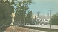
Court Street in 1910


See also
 In Spanish: Haverhill (Nuevo Hampshire) para niños
