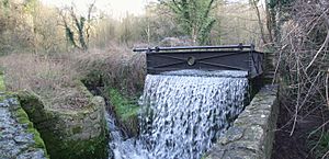
Loose Stream facts for kids
Quick facts for kids Loose Stream |
|
|---|---|
| Other name(s) | River Loose, Langley Stream |
| Country | England |
| Region | Kent |
| District | Maidstone |
| Physical characteristics | |
| Main source | Langley Maidstone 51°14′4″N 00°35′3″E / 51.23444°N 0.58417°E |
| River mouth | Confluence with River Medway Tovil 51°15′56″N 00°30′36″E / 51.26556°N 0.51000°E |
| Length | 8 km (5.0 mi) |
| Basin features | |
| Tributaries |
|
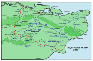
The Loose Stream, also known as the River Loose or Langley Stream, is a small river in Kent, England. It flows into the River Medway. This stream is special because it powered many watermills along its short path.
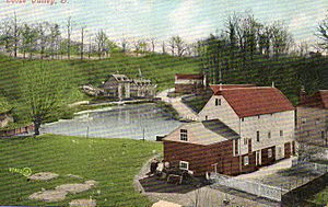
The Loose Stream starts in Langley. It then flows through Boughton Monchelsea and Loose. Finally, it joins the Medway at Tovil. The river flows through a deep valley. You can still see signs of the old paper and wool industries here. The stream was dammed in many places, creating lots of mill ponds.
Contents
- Watermills: Powering the Past
- Brishing Court Mill: A Possible Old Mill
- Leg-o-Mutton Mill: Shaped Like Its Name
- Old (Gurney's) Mill: A Paper Mill
- Loose Village Watermill: Grinding Corn
- Little Ivy Mill: From Cloth to Corn
- Great Ivy Mill: Early Turbine Power
- Bockingford Mill: Now a Home
- Hayle Mill: Famous for Handmade Paper
- Crisbrook Mills: Pumping Water
- Tovil Mills: Industrial History
- A Small Tributary and Its Mill
- Wildlife and Nature in Loose Valley
Watermills: Powering the Past
Long ago, the Loose Stream was a busy place. It had many mills that used the power of the flowing water. Early records mention many fulling mills (for cleaning and thickening cloth) and corn mills (for grinding grain).
Over time, the cloth industry changed. Paper making became more important in the 1800s. This was because the stream's water was very clean, which is perfect for making paper.
Brishing Court Mill: A Possible Old Mill
TQ 779 515 51°14′07″N 0°32′51″E / 51.23528°N 0.54750°E The old Brishing Court estate might have had a mill. There isn't much proof, though. If it existed, it was likely taken down by the mid-1700s.
Leg-o-Mutton Mill: Shaped Like Its Name
TQ 762 521 51°14′27″N 0°31′31″E / 51.240748°N 0.525276°E This mill got its name from its mill pond, which was shaped like a leg of mutton. The Wilson family owned it in the 1870s. Later, the mill building was turned into three small houses. These houses are now gone. The mill likely used an overshot waterwheel. This type of wheel is turned by water flowing over the top.
Old (Gurney's) Mill: A Paper Mill
TQ 760 521 51°14′27″N 0°31′21″E / 51.240810°N 0.522413°E Only the foundations of this old paper mill remain today. It was located near Salts Lane. The mill was taken down after the First World War. It had a large overshot waterwheel.
Loose Village Watermill: Grinding Corn
TQ 758 522 51°14′30″N 0°31′11″E / 51.241770°N 0.519600°E This was a corn mill, used for grinding grain into flour. It was probably the mill mentioned in early records. It had an overshot waterwheel that powered three pairs of millstones. The mill worked until the First World War, then it was demolished.
Little Ivy Mill: From Cloth to Corn
This mill was once a fulling mill in the 1500s. Later, it became a paper mill. Finally, it was a corn mill. In 1912, it was changed into a house. The waterwheel and other machinery were removed.
Great Ivy Mill: Early Turbine Power
This mill started as a fulling mill and later became a paper mill. Its overshot waterwheel was replaced by a water turbine. A turbine is a machine that uses the flow of water to create power. Paper making stopped here before the First World War.
Bockingford Mill: Now a Home
TQ 75681 53644 51°15′18″N 0°30′58″E / 51.254896°N 0.516199°E This mill was first a fulling mill. By the mid-1800s, it was used for grinding corn. The building you see today is from around 1880. It stopped working around 1892. The mill was later made bigger and turned into a house. The frame of its large cast iron waterwheel is still under the building.
Hayle Mill: Famous for Handmade Paper
TQ 756 538 51°15′22″N 0°31′03″E / 51.256207°N 0.517523°E Hayle Mill has been a mill site for many centuries. The last mill here was a paper mill, built in 1808. It was famous for making handmade paper until 1987. The Green family owned it for a long time, from 1817 to 2002.
In 1905, the owner, Herbert Green, worried about a new railway line. He thought smoke from the trains would harm his paper making. A longer tunnel was built for the railway, which made him happy. He believed a longer tunnel meant the line might not be built.
The mill house burned down in 2003, but the mill itself survived. The house was rebuilt and the mill was turned into apartments. The waterwheel is special. It can use water in two different ways to turn the wheel.
Crisbrook Mills: Pumping Water
Upper Crisbrook Mill: A Restored Wheel
TQ 756 541 51°15′32″N 0°30′55″E / 51.259018°N 0.515263°E
This mill building is from the 1600s. It had a cast iron overshot waterwheel that pumped water. It worked until the 1960s. The waterwheel was broken in the 1970s but has now been fixed. The mill buildings were turned into houses around 1975.
Lower Crisbrook Mill: Only Walls Remain
TQ 756 542 51°15′36″N 0°30′55″E / 51.259916°N 0.515312°E
This mill is from the late 1700s. It was a corn mill around 1719. It had an overshot waterwheel that powered four pairs of millstones. The mill last worked in 1905. Its machinery was removed about 30 years later. Today, only parts of the walls are left.
Tovil Mills: Industrial History
Upper Tovil Mill: A New Beginning
TQ 7545 5445 51°15′44″N 0°30′48″E / 51.262208°N 0.513287°E This mill was first a fulling mill, then a paper mill. It had an overshot waterwheel. In 1894, it burned down. Albert Reed bought the damaged mill and rebuilt it. This became the start of the famous company, Reed International. The rebuilt mill used steam power instead of water. The site was cleared in the 1980s for new houses.
Lower Tovil Mill (Allnut Mill): Now Houses
TQ 7520 5475 51°15′54″N 0°30′35″E / 51.264980°N 0.509854°E This mill was also a fulling mill, then a paper mill. Its large overshot waterwheel was removed in 1941. Paper making continued after the war. All the buildings have now been taken down and replaced with houses.
Bridge Mill: Many Different Jobs
TQ 750 547 51°15′53″N 0°30′25″E / 51.264592°N 0.506966°E Bridge Mill had many uses over time. It started as a fulling mill, then a corn mill. In the 1700s, it became a powder mill (for making gunpowder) and later an oil mill. Finally, Bridge Mill was a paper mill. It stopped working in the late 1900s. The site has been cleared for new houses.
A Small Tributary and Its Mill
A smaller stream flows into the Loose Stream in the village of Loose. This small stream also powered a watermill.
Watermill on the Tributary
Upper Mill, Loose: Another Busy Spot
This mill was first a fulling mill, then a paper mill, and finally a corn mill. It had an overshot waterwheel that powered three pairs of stones. The Wilson family owned this mill in the 1870s. It closed in 1908 and has since been demolished.
Wildlife and Nature in Loose Valley
The Loose Valley is just south-east of Maidstone. It marks the edge between the town and the countryside. This valley is a great place for wildlife. It has many ponds, the Loose Stream, and large areas of grassland.
The Environment Agency says the water in the Loose Stream is 'very good'. This is especially true near where it meets the River Medway.
The eastern side of the valley has horse pastures. Then it turns into long, narrow fields with woods and bushes along the edges. Cattle lightly graze these fields. The Loose Amenities Association owns and manages this part of the valley. They care for it for wildlife, its natural beauty, and for people to enjoy. It became a Conservation Area in 2000.
Plants of the Valley
A recent survey of the village pond in Loose found many different plants. These include:
- water mint
- meadowsweet
- common reed mace
- water dropwort
- bittersweet
- yellow iris
- branched bur-reed
- greater tussock sedge
- brooklime
- water figwort
- water forget-me-not
- great willowherb
- marsh marigold
On the dry grasslands of the upper valley, you can find:
- meadow vetchling
- meadow-pea
- bird's-foot trefoil
In the areas with bushes and small trees, you'll see:
- hawthorn
- blackthorn
- rose
This habitat is very important. It helps animals like dormouses, warblers, and butterflies.
The woodlands in the Loose Valley have trees like:
- oak
- ash
- sycamore
- hazel
- sweet chestnut
Birds and Animals You Might See
The Crisbrook ponds are home to moorhens, coots, and tufted ducks. Canada geese visit in the mornings. You might also see egrets and kingfishers eating fish. The old quarries provide nesting tunnels for kingfishers.
Winter is a great time for birdwatching. You can often spot:
- kingfisher
- little grebe
- little egret
- water rail
- ring-necked parakeet
- grey wagtail
- mallard
- moorhen
- black headed gull
- grey heron
- jackdaw


