Hellertown, Pennsylvania facts for kids
Quick facts for kids
Hellertown, Pennsylvania
|
||
|---|---|---|

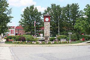
Detwiller Plaza in Hellertown in June 2008
|
||
|
||

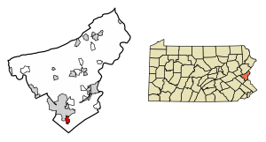
Location of Hellertown in Northampton County, Pennsylvania (left) and of Northampton County in Pennsylvania (right)
|
||
| Country | United States | |
| State | Pennsylvania | |
| County | Northampton | |
| Named for | Christopher Heller | |
| Area | ||
| • City | 1.32 sq mi (3.41 km2) | |
| • Land | 1.31 sq mi (3.40 km2) | |
| • Water | 0.00 sq mi (0.01 km2) | |
| Elevation | 322 ft (98 m) | |
| Population
(2020)
|
||
| • City | 6,132 | |
| • Density | 4,673.78/sq mi (1,805.07/km2) | |
| • Metro | 865,310 (US: 68th) | |
| Time zone | UTC-5 (EST) | |
| • Summer (DST) | UTC-4 (EDT) | |
| Zip Code |
18055
|
|
| Area codes | 610 and 484 | |
| FIPS code | 42-33744 | |
| Primary airport | Lehigh Valley International Airport | |
| Major hospital | Lehigh Valley Hospital–Cedar Crest | |
| School district | Saucon Valley | |
Hellertown is a small town, called a borough, located in Northampton County, Pennsylvania. In 2020, about 6,131 people lived there. Hellertown is part of the larger Lehigh Valley area, which is home to over 860,000 people.
One cool thing about Hellertown is that it's home to Lost River Caverns, which are natural caves made of limestone.
Contents
Geography: Where is Hellertown?
Hellertown is located at 40°35′3″N 75°20′17″W. This means it's in the northeastern part of the United States. The U.S. Census Bureau says the borough covers about 1.3 square miles (3.4 square kilometers) of land.
History: How Hellertown Began
Early Days: Before Hellertown Was a Town
Before Hellertown was officially founded, the area was home to different American Indian groups. Later, European settlers also came to live here.
18th Century: The Founding of Hellertown
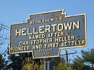
Hellertown was started in 1742 by two brothers, Christopher and Simon Heller. They were from a region in Germany called the Palatines. They traveled from Rotterdam and arrived in Philadelphia in 1738.
Christopher Heller got the official papers for his land in September 1742. His brother Simon got his land papers a few years later, in October 1746. Together, they owned about 176 acres of land near the Lehigh Mountain and the Saucon Creek. They built their family farm, which they called "delay."
19th Century: Growth and Industry
By 1820, Hellertown was a small community with 13 houses, 18 families, three taverns (like inns), two stores, and a grist-mill (where grain was ground into flour). About 73 people lived there, and the town was known for making linseed oil.
The first school in Hellertown was built in 1845. Before that, children were taught in different homes.
In the late 1840s, Hellertown started to change from a farming town to a busy industrial center. Coal yards were built in 1848, and the Lower Saucon Ironworks opened in 1849. This growth sped up in 1856 when the North Pennsylvania Railroad came through Hellertown. A man named Rudolphus Kent bought land to build a train station. The first small wooden station was replaced by a bigger stone one in 1868.
In 1858, the town got its first newspaper, The Hellertown Telegraph, but it only lasted for a year. More factories opened, including a large iron foundry in 1866 and a steel foundry in 1872. A Planing mill (for shaping wood) was built in 1874, followed by a furniture factory and a flour mill in 1875. The Saucon Savings bank also opened in 1871.
In 1870, the original school building from 1845 was bought and turned into an Evangelical Church. This was the first church in Hellertown. Before this, religious services were held in people's homes. The town also had social groups like the Odd Fellows lodge (since 1867) and the Sons of Hermann (since 1869).
In 1874, the Union Cemetery became the town's first cemetery. In 1875, another newspaper, The Saucon Advertiser, started but also closed quickly. By that year, Hellertown had grown quite a bit. It had five stores, two hardware stores, one drug store, two carriage factories, a foundry, a grist-mill, a saw-mill, a planing-mill, two furnace stacks, three hotels, a coal and lumber yard, a furniture factory, a town hall, a bank, two churches, and nearly 1,000 people.
Population: Who Lives in Hellertown?
| Historical population | |||
|---|---|---|---|
| Census | Pop. | %± | |
| 1880 | 605 | — | |
| 1890 | 708 | 17.0% | |
| 1900 | 745 | 5.2% | |
| 1910 | 915 | 22.8% | |
| 1920 | 3,008 | 228.7% | |
| 1930 | 3,851 | 28.0% | |
| 1940 | 4,031 | 4.7% | |
| 1950 | 5,435 | 34.8% | |
| 1960 | 6,716 | 23.6% | |
| 1970 | 6,615 | −1.5% | |
| 1980 | 6,025 | −8.9% | |
| 1990 | 5,662 | −6.0% | |
| 2000 | 5,606 | −1.0% | |
| 2010 | 5,898 | 5.2% | |
| 2020 | 6,132 | 4.0% | |
| Sources: | |||
In 2000, there were 5,606 people living in Hellertown. The population density was about 4,181 people per square mile. Most people (98.20%) were White, with smaller numbers of African American, Native American, and Asian residents. About 2.48% of the population was Hispanic or Latino.
There were 2,448 households. About 24.7% of these households had children under 18 living with them. The average household had 2.29 people, and the average family had 2.85 people.
The population was spread out by age:
- 20.2% were under 18 years old.
- 29.0% were between 25 and 44 years old.
- 23.1% were 65 years or older.
The median age (the middle age) in Hellertown was 42 years.
Transportation: Getting Around Hellertown
As of 2010, Hellertown had about 24.26 miles of public roads. Most of these roads (20.68 miles) are taken care of by the borough itself. The rest (3.58 miles) are maintained by the Pennsylvania Department of Transportation (PennDOT).
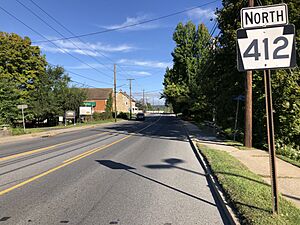
Pennsylvania Route 412 is a main road that goes through Hellertown. It's also called Main Street. If you go north on PA 412, you'll reach Bethlehem. If you go south, you'll enter Bucks County.
Just outside Hellertown, PA 412 connects to Interstate 78. This major highway can take you west to cities like Allentown and Harrisburg, or east to Easton and even New York City.
For public transportation, LANta offers bus service in Hellertown. Route 215 runs Monday through Saturday, going north to Bethlehem and the Lehigh Valley International Airport. Route 105 provides Sunday service to Bethlehem and the Lehigh Valley Mall.
You can also catch buses to New York City from Hellertown. Klein Transportation and Trans-Bridge Lines offer service from a special parking area (a park and ride lot) near the I-78 and PA 412 interchange. Hellertown used to have train service to Bethlehem and Philadelphia, but it stopped in 1981.
Education: Schools in Hellertown
Hellertown and Lower Saucon Township share a school system called the Saucon Valley School District. This district includes an elementary school, a middle school, and Saucon Valley High School.
Notable People from Hellertown
Hellertown has been home to several interesting people, including:
- Carl Benjamin Boyer: A famous historian.
- Glenn Hetrick: A special makeup effects artist and designer.
- Sandy Koufax: A legendary baseball player for the Los Angeles Dodgers who is in the Hall of Fame. He spends his summers in Hellertown.
- Eugene J. McGuinness: A former Bishop of Oklahoma City-Tulsa.
- Ted Poley: The lead singer of the rock band Danger Danger.
- Allen Woodring: A gold medalist in the 200 meters at the 1920 Summer Olympics.
See also
 In Spanish: Hellertown para niños
 | John T. Biggers |
 | Thomas Blackshear |
 | Mark Bradford |
 | Beverly Buchanan |


