Hermenegildo Capelo facts for kids
Quick facts for kids
Hermenegildo Capelo
|
|
|---|---|
 |
|
| Born | 1841 Palmela, Portugal
|
| Died | 1917 (aged 75–76) Lisbon, Portugal
|
| Nationality | Portuguese |
| Occupation | Navy officer, explorer |
| Known for | First European (alongside Roberto Ivens) to cross Central Africa from coast to coast between Angola and Mozambique. |
| Military career | |
| Allegiance | |
| Service/ |
|
| Years of service | 1860 – 1910 |
| Rank | Vice admiral |
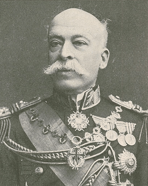
Hermenegildo de Brito Capelo (born in Palmela, 1841 – died in Lisbon, 1917) was a brave officer in the Portuguese Navy. He was also a famous Portuguese explorer. Capelo helped map parts of southern Central Africa that Europeans did not know about. These areas were between Angola and Mozambique in the 1870s and 1880s.
Along with Roberto Ivens, he made history. They were the first Europeans to cross Central Africa from one coast to the other. This amazing journey went between Angola and Mozambique. Hermenegildo Capelo later became an important aide to King Luis I and King Carlos I of Portugal. He also rose to the rank of vice-admiral. His military career ended in 1910 when King Manuel II of Portugal went into exile.
Contents
Hermenegildo de Brito Capelo was born in Palmela, Portugal. This town is about 25 kilometers (15 miles) south of Lisbon. He was one of six brothers. His father was Major Félix António Gomes Capelo.
In 1860, Capelo began his career in the Portuguese Navy. He sailed to Angola, in southwest Africa. He served on the ship D Estefânia. Prince Luís, who later became King Luís I, commanded this ship. Capelo stayed at a naval station for three years. He then returned to Lisbon in 1863.
He sailed to Africa again in 1866. He visited Angola and stayed there until 1869. Before returning to Lisbon in 1876, his travels took him to Mozambique, Cape Verde, Guinea, and even China.
Exploring Africa
In 1875, Luciano Cordeiro started the Lisbon Geographic Society. He also created the Portuguese National Commission of Exploration and Civilization of Africa. This group wanted to make people more aware of Portugal's colonies in Africa. They also aimed to raise money for scientific trips. These trips would help map out Portuguese territory in Africa.
These expeditions helped discover the Kwango River and its connection to the Zaire River. They also helped map the Zambezi River basin. This work completed the map of southern Africa. These explorations were important because European nations were competing for land in Africa. Portugal needed to show its presence there. This competition led to the famous Berlin Conference in 1885. Portugal wanted to connect its lands between Angola and Mozambique. This ambition later led to Britain issuing the British Ultimatum to Portugal in 1890.
First Big Expedition: Benguela to Iaca
Planning the Journey
On May 11, 1877, Hermenegildo Capelo was chosen for a big scientific trip into Central Africa. He would travel with another navy officer, Roberto Ivens, and Serpa Pinto. The Lisbon Geographic Society supported this expedition. Their goal was to study the Kwango River and its links to the Zaire River. They also wanted to explore areas south and southeast of the Zambezi and Kunene rivers.
The Expedition Begins

Capelo, Ivens, and Serpa Pinto started their journey on July 7, 1877. However, they soon disagreed on the expedition's main goal. Serpa Pinto wanted to explore eastwards to Mozambique. Capelo, on the other hand, aimed to reach Pretoria and possibly Durban in South Africa. Because of this disagreement, the expedition split up.
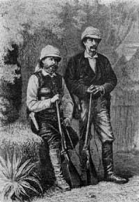
Capelo and Ivens explored the region of Bié. They traveled up to the lands of Iaca. They mapped the courses of the Luando, Kubango, and Tohicapa rivers. On March 1, 1880, Lisbon received exciting news from Capelo and Ivens. Their expedition was a great success! They wrote a book about their journey called De Benguela às Terras de Iaca (From Benguela to the Lands of Iaca).
Crossing Africa: Angola to Mozambique
After their first successful trip, Capelo and Ivens were eager for another, even bigger adventure. They had explored the Bié Plateau and the Zambezi River, even reaching Victoria Falls.
Planning the Great Crossing
The Portuguese government wanted a complete map of its colonies. So, on April 19, 1883, Pinheiro Chagas, the Overseas Minister, created a Cartography Commission. One of its main goals was to map a trade route between Angola and Mozambique. This important task was decided on November 5. The commission then made all the necessary plans. Capelo and Ivens were chosen for this new exploration. Their mapping skills, enthusiasm, and age made them perfect for the challenging mission.
The Epic Journey
Between 1884 and 1885, Capelo and Ivens explored a vast area. They traveled from the coast of Angola to the Huila plain. Then they went through the interior of Quelimane in Mozambique. They continued their studies of rivers and water patterns. They also took notes on the people they met and their languages.
They successfully established a long-sought-after land route. This route connected the coasts of Angola and Mozambique. They explored huge regions in the middle of these two territories. Their amazing achievements were written down in a two-volume book. It was called De Angola à Contra-Costa (From Angola to the Other Coast).
Capelo and Ivens started this expedition on January 6, 1884. They returned to Lisbon on September 20, 1886. King Luís I of Portugal gave them a triumphant welcome.
Later Career and Honors
Hermenegildo Capelo became the vice-president of the Overseas Institute. Queen Dona Amélia was its first president. Capelo's great vision and organizing skills greatly helped Portugal. He worked alongside other important figures like Roberto Ivens and Luciano Cordeiro. The Portuguese government recognized his valuable contributions to the country.
Capelo became an aide-de-camp to King Luis I and King Carlos I of Portugal. He was also the chief of the military house for King Manuel II. He served as Portugal's Minister to the Sultan of Zanzibar. He also created a geographical map of the province of Angola.
Capelo was promoted to rear-admiral on May 17, 1902. He became vice-admiral on January 18, 1906. Capelo was very loyal to King Manuel II. He stayed with the King until he went into exile on October 5, 1910. On October 24 of the same month, Capelo was dismissed, and his military career ended.
In Oporto, a street and a metro station are named after him. He also appeared on the 1000 Angolan escudo banknote issued in 1956.
See also
 In Spanish: Hermenegildo Capelo para niños
 | Emma Amos |
 | Edward Mitchell Bannister |
 | Larry D. Alexander |
 | Ernie Barnes |

