Hewitt Peak facts for kids
Quick facts for kids Hewitt Peak |
|
|---|---|

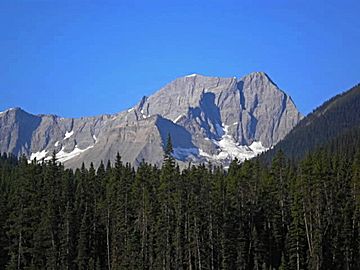
Hewitt Peak seen from Highway 93
|
|
| Highest point | |
| Elevation | 3,066 m (10,059 ft) |
| Prominence | 548 m (1,798 ft) |
| Parent peak | Tumbling Peak (3121 m) |
| Geography | |
| Location | Kootenay National Park British Columbia, Canada |
| Parent range | Vermilion Range Canadian Rockies |
| Topo map | NTS 82N01 |
| Geology | |
| Age of rock | Cambrian |
| Type of rock | Limestone |
| Climbing | |
| First ascent | 1906, Dominion Land Survey |
| Easiest route | Scrambling |
Hewitt Peak is a tall mountain in the Canadian Rockies, standing 3,066 metres (about 10,060 feet) high. It is located on the western edge of Kootenay National Park in British Columbia, Canada. People sometimes call this mountain Mammoth Peak because its shape looks a bit like a mammoth. It was also once known as Mount 10060, which was its height in feet. The mountain does not have an official name yet. Its closest taller neighbor is Tumbling Peak, which is about 2.5 kilometres (1.6 miles) away. Both peaks are part of the Vermilion Range. If you are visiting the park, you can often see Hewitt Peak from Highway 93, also called the Banff–Windermere Highway.
Contents
History of Hewitt Peak
First Climbs and Naming
The first time anyone climbed to the top of Hewitt Peak was in 1906. This climb was done by a group called the Dominion Land Survey. They were mapping out the land.
In 1933, a climber named Kate Gardiner and her team were exploring nearby mountains. They named this peak "Mount 10060" because of its height. The name "Hewitt Peak" might have come from a few different people. It could be named after Hewitt Bostock, who was a Canadian politician. It might also be named after Martin Hewitt, an adventurer, or James J. Hewitt.
Geology of the Mountain
What Hewitt Peak is Made Of
Hewitt Peak is mostly made of a type of rock called limestone. Limestone is a sedimentary rock. This means it formed over millions of years from layers of tiny bits of sand, mud, and shells that settled at the bottom of ancient shallow seas.
How the Mountain Formed
The layers of rock that make up Hewitt Peak were laid down during the Precambrian and Jurassic periods. These are very long periods of Earth's history. Later, during a time called the Laramide orogeny, huge forces pushed these rock layers up. This movement caused the rocks to fold and break, creating the mountains we see today. The older sedimentary rock was pushed up and over younger rock layers.
Climate Around Hewitt Peak
Weather Conditions
Hewitt Peak is in a subarctic climate zone. This means it has very cold and snowy winters. The summers are usually mild. Winter temperatures can often drop below −20 °C (or −4 °F). With the wind, it can feel even colder, sometimes below −30 °C (or −22 °F).
Water Flow from the Peak
When snow melts or rain falls on the mountain, the water flows off. This water, called runoff, goes in two main directions. Water from the east side of the mountain drains into Numa Creek. Numa Creek then flows into the Vermilion River. Water from the west side of the mountain flows into streams that eventually join the Kootenay River.
 | Lonnie Johnson |
 | Granville Woods |
 | Lewis Howard Latimer |
 | James West |


