High Level facts for kids
Quick facts for kids
High Level
|
||
|---|---|---|
|
Town
|
||
| Town of High Level | ||
 |
||
|
||

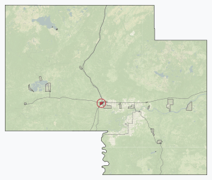
Location in Mackenzie County
|
||
| Country | Canada | |
| Province | Alberta | |
| Region | Northern Alberta | |
| Planning region | Lower Peace | |
| Specialized municipality | Mackenzie County | |
| Incorporated | ||
| • New town | June 1, 1965 | |
| Area
(2021)
|
||
| • Land | 28.7 km2 (11.1 sq mi) | |
| Population
(2021)
|
||
| • Total | 3,922 | |
| • Density | 136.7/km2 (354/sq mi) | |
| Time zone | UTC−07:00 (MST) | |
| • Summer (DST) | UTC−06:00 (MDT) | |
| Forward sortation area |
T0H 1Z0 & T0H 4J0
|
|
| Area code(s) | 780, 587, 825 | |
| Highways | Highway 35 Highway 58 |
|
High Level is a town in northern Alberta, Canada. It's found where two main roads, the Mackenzie Highway (Highway 35) and Highway 58, meet. This town is about 733 kilometers (455 miles) north of Edmonton and 725 kilometers (450 miles) south of Yellowknife, Northwest Territories. High Level is part of Mackenzie County and was started in 1947. It serves as a hub for about 20,000 people living in the surrounding area.
Contents
High Level's Past: A Brief History
The name High Level comes from the high ground that separates the Peace and Hay Rivers. The first settlement was a stopping place for travelers, not a town, located about 5.6 kilometers (3.5 miles) north of where the town is today. This spot was along an old freighting trail.
For many years, High Level was also known as Tloc Moi, which means "Hay Meadow." Fur traders first came to this area in 1786. However, High Level wasn't truly settled until 1947. This happened because a road was built to Fort Vermilion, which helped decide the town's current location.
High Level got its first power plant in 1957. A year later, the first post office was built. In the 1960s, oil fields were discovered nearby. This led to the Mackenzie Northern Railway being extended to the area in 1963, helping the town grow even more.
High Level's Location and Environment
High Level is at the northern edge of the Peace River Country. It has some of the most northern land in Canada that is good for farming. To the north and west, the town is surrounded by muskeg tundra, which is a type of swampy, frozen ground.
High Level's Climate
High Level has a subarctic climate. This means it has very cold winters and warm summers. Most of the rain and snow falls during spring and summer. The highest temperature ever recorded was 36.0°C (96.8°F) on July 9, 2024. The coldest was -50.6°C (-59.1°F) on January 13, 1972.
Even though it's called "High Level," the town is actually quite low in elevation compared to other places in Alberta. This low elevation can cause extreme temperatures. In winter, very cold air often settles over the area. In summer, air coming from higher places warms up as it moves down to High Level.
| Climate data for High Level (High Level Airport) Climate ID: 3073146; coordinates 58°37′17″N 117°09′53″W / 58.62139°N 117.16472°W; elevation: 338 m (1,109 ft); 1981−2010 normals |
|||||||||||||
|---|---|---|---|---|---|---|---|---|---|---|---|---|---|
| Month | Jan | Feb | Mar | Apr | May | Jun | Jul | Aug | Sep | Oct | Nov | Dec | Year |
| Record high humidex | 11.4 | 14.2 | 16.4 | 29.8 | 33.8 | 35.0 | 39.8 | 36.4 | 32.2 | 26.2 | 13.4 | 13.7 | 39.8 |
| Record high °C (°F) | 11.3 (52.3) |
14.6 (58.3) |
17.4 (63.3) |
30.2 (86.4) |
33.9 (93.0) |
31.5 (88.7) |
34.4 (93.9) |
35.2 (95.4) |
30.2 (86.4) |
25.2 (77.4) |
15.0 (59.0) |
14.2 (57.6) |
35.2 (95.4) |
| Mean daily maximum °C (°F) | −15.0 (5.0) |
−10.4 (13.3) |
−2.4 (27.7) |
8.7 (47.7) |
16.2 (61.2) |
21.3 (70.3) |
23.0 (73.4) |
21.1 (70.0) |
14.8 (58.6) |
5.3 (41.5) |
−7.7 (18.1) |
−12.8 (9.0) |
5.2 (41.4) |
| Daily mean °C (°F) | −20.4 (−4.7) |
−16.9 (1.6) |
−9.4 (15.1) |
2.0 (35.6) |
9.1 (48.4) |
14.3 (57.7) |
16.5 (61.7) |
14.4 (57.9) |
8.4 (47.1) |
0.4 (32.7) |
−12.3 (9.9) |
−18.2 (−0.8) |
−1.0 (30.2) |
| Mean daily minimum °C (°F) | −25.8 (−14.4) |
−23.3 (−9.9) |
−16.4 (2.5) |
−4.7 (23.5) |
2.0 (35.6) |
7.3 (45.1) |
9.9 (49.8) |
7.6 (45.7) |
1.9 (35.4) |
−4.6 (23.7) |
−16.8 (1.8) |
−23.5 (−10.3) |
−7.2 (19.0) |
| Record low °C (°F) | −50.6 (−59.1) |
−46.1 (−51.0) |
−45.0 (−49.0) |
−32.2 (−26.0) |
−13.7 (7.3) |
−3.6 (25.5) |
−0.2 (31.6) |
−4.4 (24.1) |
−13.9 (7.0) |
−36.3 (−33.3) |
−43.4 (−46.1) |
−47.2 (−53.0) |
−50.6 (−59.1) |
| Record low wind chill | −57.1 | −51.1 | −50.3 | −35.8 | −22.1 | −3.8 | 0.0 | −6.1 | −17.5 | −32.9 | −53.0 | −54.5 | −57.1 |
| Average precipitation mm (inches) | 19.5 (0.77) |
17.5 (0.69) |
18.2 (0.72) |
14.7 (0.58) |
35.8 (1.41) |
51.3 (2.02) |
66.2 (2.61) |
43.3 (1.70) |
31.6 (1.24) |
30.6 (1.20) |
24.5 (0.96) |
18.8 (0.74) |
372.1 (14.65) |
| Average rainfall mm (inches) | 0.67 (0.03) |
0.43 (0.02) |
1.2 (0.05) |
7.9 (0.31) |
30.2 (1.19) |
51.3 (2.02) |
66.2 (2.61) |
43.2 (1.70) |
28.8 (1.13) |
13.4 (0.53) |
1.2 (0.05) |
0.52 (0.02) |
245.0 (9.65) |
| Average snowfall cm (inches) | 24.1 (9.5) |
21.1 (8.3) |
21.5 (8.5) |
7.6 (3.0) |
6.1 (2.4) |
0.01 (0.00) |
0.0 (0.0) |
0.09 (0.04) |
2.6 (1.0) |
18.6 (7.3) |
28.8 (11.3) |
23.7 (9.3) |
154.2 (60.7) |
| Average precipitation days (≥ 0.2 mm) | 12.0 | 10.2 | 8.0 | 5.5 | 9.4 | 11.2 | 13.0 | 11.7 | 10.1 | 9.7 | 12.2 | 11.0 | 124.0 |
| Average rainy days (≥ 0.2 mm) | 0.52 | 0.42 | 0.48 | 3.0 | 8.8 | 11.2 | 13.0 | 11.7 | 9.6 | 4.9 | 1.2 | 0.72 | 65.4 |
| Average snowy days (≥ 0.2 cm) | 12.0 | 10.6 | 8.2 | 3.1 | 1.6 | 0.04 | 0.0 | 0.07 | 0.81 | 6.0 | 12.4 | 11.5 | 66.4 |
| Mean monthly sunshine hours | 52.6 | 96.2 | 178.5 | 239.4 | 280.1 | 298.2 | 295.2 | 264.4 | 168.0 | 101.3 | 46.0 | 35.3 | 2,055.1 |
| Percent possible sunshine | 23.8 | 36.8 | 48.9 | 55.4 | 53.7 | 54.5 | 54.1 | 55.3 | 43.5 | 31.7 | 19.5 | 17.7 | 41.2 |
| Source: Environment and Climate Change Canada | |||||||||||||
Animals of High Level
High Level is home to many different animals. You might see wolfs, coyotes, and ravens. Hunters can find larger animals like moose, deer, and bears. Many types of geese also live here. More than 150 different bird species are known to nest in the area.
High Level's Population
| Federal census population history |
||
|---|---|---|
| Year | Pop. | ±% |
| 1966 | 708 | — |
| 1971 | 1,614 | +128.0% |
| 1976 | 1,562 | −3.2% |
| 1981 | 2,194 | +40.5% |
| 1986 | 3,004 | +36.9% |
| 1991 | 2,849 | −5.2% |
| 1996 | 3,093 | +8.6% |
| 2001 | 3,444 | +11.3% |
| 2006 | 3,887 | +12.9% |
| 2011 | 3,641 | −6.3% |
| 2016 | 3,159 | −13.2% |
| 2021 | 3,922 | +24.2% |
| Source: Statistics Canada |
||
In 2021, the town of High Level had a population of 3,922 people. These people lived in 1,313 homes. This was a jump from its 2016 population of 3,159. The town covers a land area of 28.7 square kilometers (11.1 square miles). This means there were about 136.7 people per square kilometer in 2021.
High Level's Economy
The area around High Level is known for its oil and forests. Two big oil and gas fields, Rainbow Lake and Zama City, are located nearby. High Level provides services to these oil fields. There is also a mill that makes OSB (a type of wood panel) south of town. Another mill that makes dimensional lumber is in the town's industrial area.
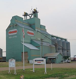
High Level has the most northern grain elevator in Canada. This means it's a major center for grain from the large farming area around it. Farmers bring their grains from up to 120 kilometers (75 miles) away. There are about 350,000 acres of farmland in the region.
Getting Around and Services in High Level
High Level offers both airplane and helicopter services. Because the town is in a somewhat remote location, special medical flights (medevac) and chartered services are available. These are provided by companies like Nor-Alta Aviation, Highland Helicopters, and Delta Helicopters.
Regular flights are offered at High Level Airport. You can fly directly to cities like Edmonton, Calgary, and other northern communities.
Telephone service is provided by companies like Telus and Northwestel. Local businesses are supported by the High Level and District Chamber of Commerce.
Learning in High Level
High Level has three public schools and one private school.
- High Level Public School was the first school built in town. It used to have all grades from kindergarten to grade 12. Now, it teaches students from grade 7 to 12.
- Spirit of the North Community School is the newest school in High Level. It opened in 2000 and teaches grades 4 to 6.
- Florence MacDougall Community School teaches younger students, from kindergarten through third grade.
- High Level Christian Academy teaches students from kindergarten through grade 9. After grade 9, students usually go to High Level Public School.
Media in High Level
High Level has its own local radio station, CKHL-FM 102.1. This station is part of the YL Country network. You can also listen to other radio stations through repeaters, like CBC Radio One and CKKX-FM. The local newspaper for the town is called The Echo.
Television is available through local repeaters that broadcast channels from Edmonton and Vancouver. These are owned by the High Level Community Hall Society. Cable television and high-speed Internet service are also available from Northwestel Cable.
 | James Van Der Zee |
 | Alma Thomas |
 | Ellis Wilson |
 | Margaret Taylor-Burroughs |


