Hoke County, North Carolina facts for kids
Quick facts for kids
Hoke County
|
|||||
|---|---|---|---|---|---|
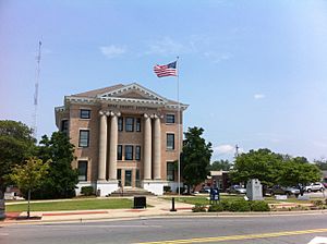
Hoke County Courthouse in Raeford
|
|||||
|
|||||
| Motto(s):
"Where Quality Living Meets Quality of Life"
|
|||||
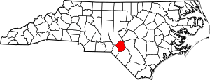
Location within the U.S. state of North Carolina
|
|||||
 North Carolina's location within the U.S. |
|||||
| Country | |||||
| State | |||||
| Founded | April 1, 1911 | ||||
| Named for | Robert F. Hoke | ||||
| Seat | Raeford | ||||
| Largest community | Raeford | ||||
| Area | |||||
| • Total | 391.68 sq mi (1,014.4 km2) | ||||
| • Land | 390.15 sq mi (1,010.5 km2) | ||||
| • Water | 1.53 sq mi (4.0 km2) 0.39% | ||||
| Population
(2020)
|
|||||
| • Total | 52,082 | ||||
| • Estimate
(2023)
|
54,446 | ||||
| • Density | 133.49/sq mi (51.54/km2) | ||||
| Time zone | UTC−5 (Eastern) | ||||
| • Summer (DST) | UTC−4 (EDT) | ||||
| Congressional district | 9th | ||||
Hoke County is a special area called a county in the state of North Carolina, USA. It's like a district with its own local government. In 2020, about 52,082 people lived here. The main town and government center is Raeford.
A big part of the Fort Liberty military base is also located in Hoke County.
Contents
History of Hoke County
Early Times
Long ago, the Tuscarora Native Americans lived in the area that is now Hoke County. Later, in the early 1700s, ancestors of the Lumbee Native Americans also lived here.
European settlers started building churches in the mid-to-late 1700s. This area was first part of Cumberland and Robeson counties. The town of Raeford began in the 1890s and became an official town in 1901. The first train tracks, from the Aberdeen and Rockfish Railroad, were laid through the area in 1899.
How Hoke County Was Created
In the early 1900s, people living far from the main towns of Cumberland and Robeson counties wanted their own county. It was hard and took a long time to travel to their courthouses. There were attempts in 1907 and 1909 to create a new "Glenn County," but they didn't succeed.
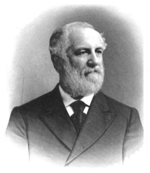
In 1911, a new effort was made. This time, they also wanted to name the county after Robert F. Hoke. He was a general in the American Civil War and a leader in the railroad business.
On February 14, 1911, the North Carolina government decided to create Hoke County. It officially started on April 1, 1911. The first government leaders were chosen by the governor of North Carolina. Raeford was chosen as the county seat. Local officials worked from rented offices until the county courthouse was built the next year. When it was created, Hoke County had about 268,000 acres of land. It had no paved roads, and most people worked in farming. About 10,000 people lived there, mostly white people from Scottish families and African Americans.
Growth and Changes
About 400 people from Hoke County served in the U.S. Army during World War I. Between 1918 and 1923, the US government bought 92,000 acres of land in the county. This was to make Camp Bragg bigger, which is now Fort Liberty.
More than 160 Hoke residents served in the military during World War II. After the war, the number of Lumbee people in the county grew. In 1952, the U.S. Army wanted to buy another 49,000 acres for Fort Bragg. But local people protested, and the plan was stopped.
In 1958, a part of northern Hoke County called Little River Township was moved to Moore County. This part was separated from the rest of Hoke County by the Fort Bragg military base. Public schools, which used to be separate for white, black, and Native American students, became integrated in the 1960s.
Geography
Hoke County covers about 391.68 square miles. Most of this is land (390.15 square miles), and a small part is water (1.53 square miles). It shares borders with Moore, Cumberland, Robeson, Scotland, and Richmond counties.
Hoke County is in North Carolina's Sandhills region and also part of the Coastal Plain. It has unique landforms called Carolina bays. Water from the county flows into the Lumber River and Cape Fear River systems. Longleaf pine trees naturally grow in this area.
Protected Natural Areas
Hoke County has several areas set aside to protect nature:
- Calloway Forest Preserve
- Hoke Community Forest
- Lumber River State Park (part of it)
- Nicholson Creek Game Land
- Rockfish Creek Game Land
- Sandhills Game Land (part of it)
Major Waterways
Many rivers and swamps flow through Hoke County, including:
- Big Marsh Swamp
- Buffalo Creek
- Drowning Creek
- Gum Swamp
- Little Raft Swamp
- Little River
- Little Rockfish Creek
- Little Rockfish Lake
- Lumber River
- MacArthur Lake
- Mountain Creek
- Quewhiffle Creek
- Raft Swamp
- Rockfish Creek
People of Hoke County
Population in 2020
In 2020, the census counted 52,082 people living in Hoke County. Raeford is the largest town. Hoke County is a "majority-minority" county. This means that more than half of the people belong to racial or ethnic groups other than non-Hispanic white.
In 2020, the population was made up of:
- 40.4% white
- 32.2% black
- 14.8% Hispanic or Latino
- 7% Native American
- 1.4% Asian
- 0.4% Native Hawaiian or Pacific Islander
Hoke County is part of the larger Fayetteville Metropolitan Statistical Area.
Population Changes Over Time
Hoke County's population has grown a lot in recent years. This is mainly because Fort Liberty has expanded.
| Historical population | ||||||||||||||||||||||||||||||||||||||||||||||||||||||||||||
|
||||||||||||||||||||||||||||||||||||||||||||||||||||||||||||
Between 1990 and 2000, the county's population grew by 47 percent. From 2000 to 2010, it went from about 34,000 to over 45,000 people. Between the 2010 and 2020 censuses, the county added 5,130 residents, growing by 17.8 percent. The white population became a smaller percentage, while the Hispanic/Latino population grew. From 2020 to 2021, Hoke County's population grew faster than the average for North Carolina.
Economy
Hoke County's economy first relied on cutting timber and making turpentine. Over the 1900s, it grew to include farming cotton and grain, and raising animals. After World War II, raising and processing chickens and turkeys became very important.
The county's economy has grown a lot recently because it is close to Fort Liberty. Raising poultry (like chickens and turkeys) is still a very important part of the local economy.
Transportation
The county government runs a public transport bus service called the Hoke Area Transit Service. Train service is provided by the Aberdeen and Rockfish Railroad.
Main Roads
These are some of the major highways that go through Hoke County:
 US 15
US 15 US 401


 US 401 Bus.
 US 501
 NC 20
NC 20 NC 211
Education
Most public schools in Hoke County are part of Hoke County Schools. An elected school board manages these schools. There's also a special program called SandHoke Early College. It's a partnership with Sandhills Community College and uses both the college and local middle and high schools.
Some parts of Fort Liberty have schools run by the Department of Defense Education Activity (DoDEA) for grades K-8. High school students living on Fort Liberty go to the public high schools in the county where they live. In 2021, about 19.8 percent of adults in Hoke County had a bachelor's degree or higher.
Healthcare
Hoke County has two hospitals: Hoke Hospital and the Hoke Campus of Moore Regional Hospital. Both are in the eastern part of the county. The county government also supports a public health department. This department has been helping more and more people as Hoke County's population grows.
Culture and Events
In 1984, Hoke County started an annual event called the Hoke Heritage Hobnob. Over time, this festival changed into the North Carolina Turkey Festival, and then the North Carolina Fall Festival. It celebrates the turkey farming industry in the state.
Several buildings and sites in the area are listed on the National Register of Historic Places. This means they are important historical places.
Communities
City
- Raeford (This is the main town and the county seat.)
Census-Designated Places
These are areas that are like towns but are not officially incorporated as cities:
Townships
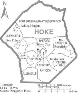
Hoke County is divided into smaller areas called townships:
- Allendale
- Antioch
- Blue Springs
- McLauchlin
- Raeford
- Quewhiffle
- Stonewall
See also
 In Spanish: Condado de Hoke para niños
 | Misty Copeland |
 | Raven Wilkinson |
 | Debra Austin |
 | Aesha Ash |


