Honeydew, California facts for kids
Quick facts for kids
Honeydew
|
|
|---|---|

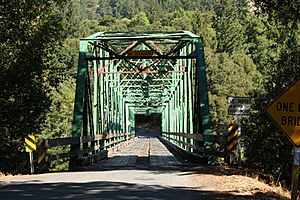
Bridge over the Mattole River in Honeydew
|
|
| Country | United States |
| State | California |
| County | Humboldt County |
| Elevation | 322 ft (98 m) |
Honeydew (once called Honey Dew) is a small, unincorporated community in Humboldt County, California. This means it's a town without its own local government. It's about 17 miles (27 km) south of Scotia and sits 322 feet (98 meters) above sea level. Honeydew is located about 15 miles (24 km) from the Pacific Ocean in a special area called the Lost Coast, near the King Range.
In Honeydew, you'll find a general store, an elementary school, a post office, and a few houses. Many people who live here actually live in the hills around the Mattole Valley. This valley is named after the Mattole River, which flows through it. The area's ZIP code is 95545, and it uses area code 707 for phones.
Contents
Honeydew's History
The first post office in Honeydew opened in 1926. Long ago, in the 1800s, Honeydew was an important stop for stagecoaches and mail delivery. Other towns like Petrolia and Capetown were also stagecoach stops.
Getting to Honeydew
The coastal mountains around Honeydew are very steep and challenging to build roads through. Because of this, it was too expensive to build state highways or county roads here. This makes it one of the most undeveloped parts of the California coast. California State Route 1, a famous coastal highway, stops before reaching this area. It merges with U.S. Route 101, which runs further inland.
There are three main roads that lead to Honeydew:
- One road comes from Garberville, a town in Southern Humboldt. This road follows Wilder Ridge Road.
- Another road comes off U.S. Route 101 (a state highway) and goes through the Redwood forest.
- The third road comes from Ferndale in the north. This route is known locally as "the Wildcat," named after the bobcats that live in the area. It offers amazing views of the Pacific Ocean and the nearby town of Petrolia.
All three roads are winding mountain roads. They can be tricky to drive on, especially when the weather is bad or during foggy conditions near the coast.
The weather in the Mattole Valley can change quickly. Just a few miles west, it might be foggy and cool. But in the inner valleys, summer temperatures can reach 100°F (38°C). The area also gets a lot of rain, sometimes up to 100 inches (2,540 mm) per year.
It's a good idea for visitors to be ready for sudden weather changes. Cell phone service is limited, mostly available near the Honeydew General Store and the river valley. Electricity and road access can also be cut off during bad weather. Travelers should always check local road reports before visiting. Fuel is usually available at the General Store and in Petrolia, about 15 miles (24 km) west.
Schools in Honeydew
The Honeydew area has three schools:
- Honeydew Elementary School
- Mattole Valley Triple Junction High School
- Honeydew Charter School #159
Honeydew's Culture and Community
Because Honeydew is a bit isolated, it has a strong small-town feel. There are no motels in town, but you can find several campgrounds nearby if you want to visit.
The local firefighters, called the Honeydew Volunteer Fire Company, host a fun event every summer. It's called "Roll on the Mattole," and it helps them raise money to keep the fire company running. The region has a long history of raising sheep and cattle.
The Mattole Grange is a key meeting spot for community events. It's where many local gatherings take place.
Honeydew's Climate
Honeydew has a "Mediterranean climate," which means it has warm, dry summers and mild, wet winters. It's known as one of the rainiest communities in California.
| Climate data for Honeydew, California | |||||||||||||
|---|---|---|---|---|---|---|---|---|---|---|---|---|---|
| Month | Jan | Feb | Mar | Apr | May | Jun | Jul | Aug | Sep | Oct | Nov | Dec | Year |
| Mean daily maximum °F (°C) | 52.7 (11.5) |
54.5 (12.5) |
60.0 (15.6) |
64.3 (17.9) |
70.3 (21.3) |
76.6 (24.8) |
83.0 (28.3) |
83.2 (28.4) |
82.7 (28.2) |
71.4 (21.9) |
57.3 (14.1) |
51.7 (10.9) |
67.3 (19.6) |
| Mean daily minimum °F (°C) | 38.9 (3.8) |
38.8 (3.8) |
39.4 (4.1) |
40.8 (4.9) |
44.4 (6.9) |
48.2 (9.0) |
51.2 (10.7) |
51.0 (10.6) |
49.1 (9.5) |
44.8 (7.1) |
40.9 (4.9) |
37.2 (2.9) |
43.7 (6.5) |
| Average precipitation inches (mm) | 19.55 (497) |
15.87 (403) |
15.06 (383) |
7.14 (181) |
3.00 (76) |
0.87 (22) |
0.1 (2.5) |
0.2 (5.1) |
0.78 (20) |
5.78 (147) |
13.14 (334) |
18.51 (470) |
100 (2,540.6) |
| Average precipitation days (≥ 0.01 in) | 16 | 14 | 15 | 11 | 8 | 3 | 1 | 1 | 3 | 7 | 13 | 16 | 108 |
| Source: Western Regional Climate Center | |||||||||||||
 | Shirley Ann Jackson |
 | Garett Morgan |
 | J. Ernest Wilkins Jr. |
 | Elijah McCoy |


