
Huambo facts for kids
Quick facts for kids
Huambo
Nova Lisboa (New Lisbon)
|
|||
|---|---|---|---|
|
Municipality
|
|||
.jpg) .jpg)  .jpg)  .jpg) |
|||
|
|||

Huambo
Location in Angola

Huambo
Location in Africa
|
|||
| Country | |||
| Province | Huambo | ||
| Founded | August 8, 1912 | ||
| Area | |||
| • Municipality | 2,711 km2 (1,047 sq mi) | ||
| Elevation | 1,721 m (5,646 ft) | ||
| Population
(2014 Census)
|
|||
| • Municipality | 713,134 | ||
| • Density | 263.05/km2 (681.30/sq mi) | ||
| • Metro | 1,896,147 | ||
| Time zone | UTC+1 (WAT) | ||
| Climate | Cwb | ||


Huambo, once called Nova Lisboa (which means New Lisbon in English), is a major city in Angola. It's the third largest city in the country, after the capital city Luanda and Lubango. In 2014, about 713,134 people lived in the wider Huambo area.
Huambo is the capital of the Huambo Province. It's located about 220 kilometers (137 miles) east of Benguela and 600 kilometers (373 miles) southeast of Luanda. The city is a very important stop on the Caminho de Ferro de Benguela (CFB) (the Benguela Railway). This railway connects the port of Lobito to the rich copper mining areas in Democratic Republic of the Congo's Katanga. Huambo also has its own airport, the Albano Machado Airport.
Contents
Huambo's History
How Huambo Began
The name Huambo comes from Wambu, which was one of the 14 old kingdoms of the Ovimbundu people. These kingdoms were located on the central plateau of Angola. The Ovimbundu people came from Eastern Africa a long time ago. They had a main kingdom called Bailundu as early as the 15th century. Wambu was a smaller kingdom that was part of Bailundu, but it had a lot of freedom.
People didn't know much about Wambu until the Portuguese started building the Benguela Railway. The kings of Bailundu and Wambu tried to stop the railway from being built. They would ambush workers and settlers. But eventually, the Portuguese Army took control. Huambo was officially founded on August 8, 1912, by the Governor-General of Angola, Norton de Matos.

The city of Huambo grew very quickly because of the Benguela Railway. The railway started in the coastal town of Lobito in 1902. A British businessman named Sir Robert Williams planned this railway. He wanted to connect the copper mines in Katanga, which was then in the Belgian Congo, to a port on the coast. This way, the copper could be shipped out easily. Lobito Bay was the best natural harbor in all of Africa.
Building the railway was very hard at first. The land was rough, many workers got malaria, and local people resisted. But Huambo was a great place for the railway because of its good climate and plenty of water. It became a central point for the railway. After that, the work went much faster, and the railway reached the Belgian Congo border in 1929. By then, Huambo had the most important railway workshop in Africa.
By the 1920s, Huambo was a key part of Portuguese Angola's economy. It had factories that processed food. It was also the main place to export the province's farm products. Huambo was also known for its many schools, especially the Agricultural Research Institute. This institute is now part of the College of Agricultural Science.
In 1928, Huambo was renamed Nova Lisboa, meaning "New Lisbon." This showed that the Portuguese government wanted to make it the capital of the colony someday.
In 1966, university programs for Veterinary Medicine, Agronomy, and Forestry were started in Nova Lisboa. These were part of the General University Studies of Angola, which became the University of Angola in 1968.
By the late 1960s, Nova Lisboa was famous for its International Nova Lisboa 6 Hours sports car race. The city grew a lot until Angola became independent in 1975. It became one of the most important cities in the Portuguese Overseas Province of Angola.
After Independence
.jpg)
After Angola became independent from Portugal in 1975, Nova Lisboa got its original name back – Huambo. But then, the Angolan Civil War started in 1975 and lasted until 2002. This war stopped Huambo's growth and destroyed much of its buildings and roads.
Huambo was a major battleground during the civil war. There were many fights, including the brutal 55 Day War. The city was badly damaged, and many people were killed or had to leave their homes.
When Angola became independent in 1975, Jonas Savimbi, the leader of the UNITA group, declared Huambo to be the capital of his government. This was a challenge to the MPLA group, which had its capital in Luanda. However, the MPLA took the city back on February 8, 1976, with help from Cuban soldiers. But most of the areas around Huambo stayed under UNITA's control.
.jpg)
By mid-1976, Cuban forces had set up important bases in Huambo Province. But UNITA still controlled most of the land between the towns.
People who had lost their homes started moving into towns to find safety and help. The International Committee of the Red Cross (ICRC) was one of the first aid groups to arrive in Huambo Province in 1979.
In 1984, the fighting got much worse, and even more people had to leave their homes. A big aid effort was started in the main cities of the Central Plateau. Many roads were controlled by UNITA and had hidden bombs (mines).
In May 1991, the MPLA and UNITA signed a peace agreement. United Nations groups and other aid organizations started working in Huambo between 1991 and 1992. Things slowly got better, and elections were held in September 1992. But problems started again when the election results were announced. Huambo quickly became unsafe because UNITA saw the province as their special place. Many of their leaders and soldiers gathered in the town after they lost the elections.
The MPLA government still officially controlled the city, but violence grew. By the end of 1992, all foreign aid groups had left Huambo. UNITA took full control of the town after terrible street battles. These battles started just after Christmas 1992 and were worst in mid-January 1993. The fighting in and around Huambo lasted for 55 days. The MPLA government troops left, and UNITA took over the city. Most other cities in the Central Plateau were also taken by UNITA at that time.

The war started again in August 1994. The government launched a big attack and took back control of Huambo on November 9. Soon after, they also took back all other provincial capitals. UNITA then moved its headquarters to Jamba.
The war officially ended on November 20, 1994, with the signing of the Lusaka Protocol. This step brought some hope for peace in Huambo. UNITA moved its headquarters again, this time to Bailundo, about 50 kilometers (31 miles) north of Huambo. This move worried many people.
By 1995, people and goods could move more freely in the Province. By the end of the year, United Nations peacekeepers (UNAVEM III) were in Huambo, as agreed in the Lusaka Protocol. 1996 and 1997 were better years for people living in Huambo. But people didn't return home very quickly, rebuilding was slow, and businesses didn't get back to normal.
The United Nations Security Council put rules (sanctions) on UNITA in October 1997. This was because UNITA was slow to follow the peace agreement and didn't want to give up its strongholds. Because of this, Huambo became less safe, especially in late 1998. In early December, the government attacked UNITA's last strongholds in Huambo and Kuito. This new fighting quickly spread to other parts of the country.
Many people had to leave their homes again and move to Huambo, Kuito, and Caala. Large camps for people who had lost their homes were set up in these cities. Aid groups had to leave areas controlled by UNITA. They left completely by the end of the year and focused their help in Huambo, Caala, and later, Ukuma.
The safety situation became very dangerous. Huambo and other big towns were being attacked with shells from Bailundo and other places still held by UNITA. Two C-130 Hercules planes, hired by the United Nations with 23 people on board, were shot down over Vila Nova (December 26, 1998, and January 2, 1999). They were trying to get the last UN mission members out of Huambo and back to Luanda.
The government took back the town of Bailundo in October 1999. Londuimbali, Vila Nova, and some other large towns in the Province were already under government control. By December 1999, the government had taken back control of all the main towns. At this time, the big war changed into a guerrilla war. UNITA still controlled most rural areas and would randomly attack government military or police places, and often civilian communities too.
More civilians had to leave their homes and move to Huambo and Caála.
Huambo in the 21st Century

In early 2000, there were over 25,000 people who had lost their homes in Caala, and over 40,000 in Huambo town. As international rules against UNITA became stricter, their attacks in Huambo became more frequent and destructive. This reached its worst point by the end of 2000.
In October 2001, the government launched new attacks against UNITA from the north and south of the Province. They combined military action with "cleansing operations." These operations involved moving large groups of people from rural areas into a few specific gathering points. The idea was to stop the guerrilla fighters from getting support from villages they used to control. This made it impossible for them to live in their usual areas.
In the short term, this put a lot of pressure on the resources available in safe areas of Huambo. In many cases, groups of people trapped by the conflict or unable to reach safe zones died from starvation. This was probably the hardest time for the people living in rural areas of Huambo Province during the war.
The death of Jonas Savimbi in February 2002 and a new cease-fire agreement brought peace back to the Province. This set the stage for the peace process that is still going on today and the start of a new time of growth and development.
Peace brought a new time of rebuilding and renewal in Huambo and all across Angola.
Huambo's Geography
Huambo is located in the central highlands of Angola, which are high up in the mountains. It's near where the Cunene River begins. Huambo is about 1,721 meters (5,646 feet) above sea level because it sits on a high plateau.
Huambo's Climate
Huambo has a subtropical highland climate. This means it has wet summers from October to April and dry winters from May to September. Even though it's in the tropics, Huambo has mild, spring-like temperatures all year round because it's so high up. This is common for cities with this type of climate.
September is the warmest month, with an average temperature of 21.0°C (69.8°F). June is the coolest month, with an average of 16.2°C (61.2°F). The city gets a lot of rain throughout the year, almost 1,400 millimeters (55 inches) on average. However, during the dry season from May to September, there is much less rain. June and July usually get no rain at all. Because of its high altitude, temperatures in Huambo are only a little warmer than in Pretoria, a city almost 2,000 kilometers (1,243 miles) further south. Huambo gets more sunshine in the winter (especially June and July) than in the summer, with a total of 2,273 hours of sunshine each year.
| Climate data for Huambo (1941–1970) | |||||||||||||
|---|---|---|---|---|---|---|---|---|---|---|---|---|---|
| Month | Jan | Feb | Mar | Apr | May | Jun | Jul | Aug | Sep | Oct | Nov | Dec | Year |
| Record high °C (°F) | 31.2 (88.2) |
31.1 (88.0) |
29.8 (85.6) |
29.5 (85.1) |
29.0 (84.2) |
28.4 (83.1) |
28.5 (83.3) |
30.9 (87.6) |
32.0 (89.6) |
32.0 (89.6) |
30.7 (87.3) |
30.4 (86.7) |
32.0 (89.6) |
| Mean daily maximum °C (°F) | 24.9 (76.8) |
25.2 (77.4) |
25.0 (77.0) |
25.5 (77.9) |
25.4 (77.7) |
24.6 (76.3) |
25.0 (77.0) |
27.2 (81.0) |
28.7 (83.7) |
27.3 (81.1) |
25.2 (77.4) |
24.9 (76.8) |
25.7 (78.3) |
| Daily mean °C (°F) | 19.8 (67.6) |
19.8 (67.6) |
19.8 (67.6) |
19.6 (67.3) |
18.0 (64.4) |
16.2 (61.2) |
16.6 (61.9) |
18.8 (65.8) |
21.0 (69.8) |
20.8 (69.4) |
19.8 (67.6) |
19.8 (67.6) |
19.2 (66.6) |
| Mean daily minimum °C (°F) | 14.4 (57.9) |
14.2 (57.6) |
14.4 (57.9) |
13.7 (56.7) |
10.5 (50.9) |
7.8 (46.0) |
7.9 (46.2) |
10.3 (50.5) |
13.0 (55.4) |
14.2 (57.6) |
14.3 (57.7) |
14.3 (57.7) |
12.4 (54.3) |
| Record low °C (°F) | 8.9 (48.0) |
8.4 (47.1) |
9.3 (48.7) |
7.4 (45.3) |
4.6 (40.3) |
2.1 (35.8) |
2.0 (35.6) |
4.7 (40.5) |
7.7 (45.9) |
9.4 (48.9) |
7.5 (45.5) |
9.2 (48.6) |
2.0 (35.6) |
| Average precipitation mm (inches) | 220 (8.7) |
179 (7.0) |
239 (9.4) |
146 (5.7) |
14 (0.6) |
0 (0) |
0 (0) |
1 (0.0) |
19 (0.7) |
119 (4.7) |
227 (8.9) |
234 (9.2) |
1,398 (55.0) |
| Average precipitation days (≥ 0.1 mm) | 20 | 17 | 22 | 14 | 3 | 0 | 0 | 0 | 4 | 16 | 21 | 21 | 138 |
| Average relative humidity (%) | 72 | 67 | 73 | 66 | 48 | 38 | 33 | 29 | 38 | 57 | 69 | 71 | 55 |
| Mean monthly sunshine hours | 142.6 | 141.3 | 142.6 | 171.0 | 241.8 | 270.0 | 269.7 | 254.2 | 201.0 | 164.3 | 135.0 | 139.5 | 2,273 |
| Mean daily sunshine hours | 4.6 | 5.0 | 4.6 | 5.7 | 7.8 | 9.0 | 8.7 | 8.2 | 6.7 | 5.3 | 4.5 | 4.5 | 6.2 |
| Source: Deutscher Wetterdienst | |||||||||||||
Education and Research
Huambo is home to important places for learning and science. It has two public universities: the José Eduardo dos Santos University and the Higher Institute of Education Sciences of Huambo. There are also research centers like the Veterinary Research Institute and the Agricultural Research Institute. These places focus on studying and sharing knowledge about animals and farming.
Famous People from Huambo
- Lúcio Lara (1929–2016) – An important Angolan politician.
- Gabriela Antunes (1937–2004) – An Angolan writer.
Images for kids
-
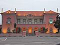
The Governor's Palace in Huambo.
-
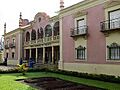
A garden in Huambo.
-

The central Post Office in Huambo.
-
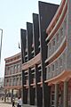
Government buildings in Huambo.
-
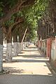
A sidewalk in Huambo.
-
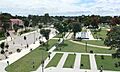
The Garden of Culture in Huambo.
-

Flag of Huambo.
-
Coat of arms of Huambo.
See Also
 In Spanish: Huambo (Angola) para niños
