List of islands in the Detroit River facts for kids
The Detroit River is a really important waterway in the Great Lakes region. It flows for about 44 kilometers (27 miles) from Lake St. Clair down to Lake Erie. This river is like a superhighway for ships, and it also forms part of the border between the United States and Canada. Most of the islands in the Detroit River are on the American side, in Wayne County, Michigan. The Canadian islands are in Essex County, Ontario. No island is split by the border; each one belongs entirely to either the U.S. or Canada.
Many of these islands are small and nobody lives on them. A lot of the islands in the southern part of the river are special nature reserves. They are part of the Detroit River International Wildlife Refuge, which helps protect animals and plants. The biggest island, where many people live, is Grosse Ile. Some islands were even made by people, like those in Gibraltar, Elizabeth Park, and Zug Island.
Islands in Michigan
Belle Isle
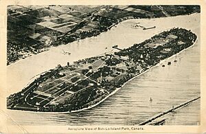
Belle Isle is a huge island, about 982 acres (4 square kilometers), located in the Detroit River near Downtown Detroit. It's the northernmost island in the river. Even though it's part of the city of Detroit, it's managed by the Michigan Department of Natural Resources as Belle Isle Park.
You can get to Belle Isle by crossing the MacArthur Bridge. No one lives on the island permanently, but it's a very popular place for visitors! It has many old, important buildings and hosts fun events. The whole island is recognized as a historic place. Belle Isle even has its own lakes and canals, with tiny islands inside them!
Calf Island
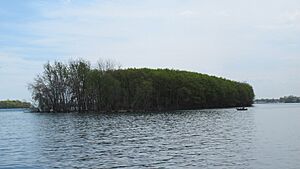
Calf Island is a smaller island, about 11 acres (4.5 hectares), located near Grosse Ile. No one lives here. It's mainly a nesting spot for birds that are migrating. In 2002, Calf Island became part of the Detroit River International Wildlife Refuge, helping to protect its wildlife.
Celeron Island
Celeron Island is about 68 acres (28 hectares) and is found close to where the Detroit River meets Lake Erie. It's the southernmost island in Grosse Ile Township. Because of erosion, it's actually two separate islands now. Celeron Island is uninhabited and is part of the Pointe Mouillee State Game Area, managed by the Michigan Department of Natural Resources.
Cherry Island
Cherry Island is an uninhabited island south of Gibraltar. It's part of Lake Erie Metropark and has a boat launch. It's also sometimes called Cherry Isle.
Elizabeth Park
Elizabeth Park is an island in Trenton that was created by people. It used to be connected to the mainland. In the mid-1800s, a canal was built, turning it into an island. It was once known as Slocum's Island. Today, this island is home to the 162-acre (66-hectare) Elizabeth Park and the Trenton Channel Power Plant. The Wayne County Bridge, which leads to Grosse Ile, crosses this island.
Grassy Island
Grassy Island is a 72-acre (29-hectare) island north of Grosse Ile. No one lives on this island, which is part of Wyandotte. It used to be much smaller, but it grew when millions of cubic yards of dirt and sediment from the River Rouge were placed there. In 2001, Grassy Island became one of the first parts of the Detroit River International Wildlife Refuge. It's hard to visit this island, and public access is limited.
Grosse Ile
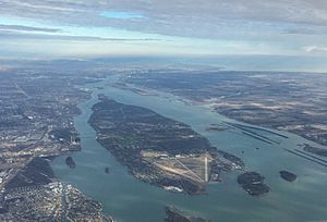
Grosse Ile is the biggest island in the Detroit River. It's about 16 kilometers (10 miles) long and 1.6 kilometers (1 mile) wide. Grosse Ile is the main island within Grosse Ile Township, which actually includes about a dozen islands. People often call it the "big island" to tell it apart from the whole township.
You can reach Grosse Ile from the mainland by two bridges: the Wayne County Bridge and the Grosse Ile Toll Bridge. The Grosse Ile Municipal Airport is on the southern end of the island. Grosse Ile has many historic buildings and is mostly a residential area, meaning many people live there. A part of the Detroit River International Wildlife Refuge, called the Gibraltar Bay Unit, is located on the southeast side of the island.
Humbug Island
Humbug Island is a long island in Gibraltar, near Calf Island. It's part of the much larger 410-acre (1.7 square kilometer) Humbug Marsh, which joined the Detroit River International Wildlife Refuge in 2004. No one lives on Humbug Island, and it's difficult to access. It's special because it's the last undeveloped shoreline on the American side of the Detroit River.
Hickory Island
Hickory Island is the southernmost island in Grosse Ile Township where people live. It's connected to Meso Island by a bridge, which then leads to Grosse Ile. The Grosse Ile Yacht Club is located on Hickory Island.
Horse Island
Horse Island is a narrow, long island in Gibraltar. It's the southeasternmost island in the city and has many homes. A bridge built in 1925 connects it to the mainland. Early settlers used to let their horses feed and mate on the island during the summer, which is how it got its name.
Main Island
Main Island is the largest and most populated island in Gibraltar. It's separated from the mainland by a narrow canal. You can reach it from the mainland by the historic Gibraltar Road–Waterway Canal Bridge. Main Island also connects to Hall Island and Horse Island by other bridges.
Mamajuda Island
Mamajuda Island used to be an island east of Grosse Ile. It was once about 30 acres (12 hectares) and had a lighthouse built in 1849. Sadly, due to erosion, the lighthouse was lost in the 1950s, and the entire island disappeared soon after. Even though it's gone, it's still shown on some maps and might even appear during very low water levels.
Meso Island
Meso Island is an island in southeast Grosse Ile Township where people live. It's located north of Hickory Island and connects to Grosse Ile by a bridge. Sugar Island is just east of Meso Island.
Mud Island
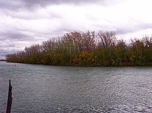
Mud Island is a 21-acre (8.5-hectare) island in Ecorse. It was given to the Detroit River International Wildlife Refuge and is the northernmost part of the refuge. Mud Island is just north of Grassy Island, and the public is not allowed to visit it.
Stony Island
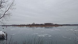
Stony Island is a 52-acre (21-hectare) uninhabited island in Grosse Ile Township, east of Grosse Ile. Its unusual shape and rocky surface come from millions of cubic yards of sediment that were dug out of the Detroit River to make a deeper shipping channel. The island has been strengthened with breakwater structures to protect its artificial wetlands. It's part of a restoration project and is mostly included in the Pointe Mouillee State Game Area.
Sturgeon Bar
Sturgeon Bar, sometimes called Sturgeon Bar Island, is the southernmost island in the Detroit River. It's part of Brownstown Charter Township. This island is part of the Lake Erie Metropark, which is also a unit within the Detroit River International Wildlife Refuge.
Sugar Island
Sugar Island is an uninhabited 29-acre (12-hectare) island off the southwest coast of Grosse Ile. It's east of Meso Island.
In the 1880s, Sugar Island became a popular vacation spot with an amusement park and other fun places. Ferries brought visitors to the island until the amusement park closed in the 1940s. The island then became deserted. In 2012, the United States Fish and Wildlife Service bought the island, and it was added to the Detroit River International Wildlife Refuge. There are no buildings on the island now, and public access is restricted.
Zug Island
Zug Island is a 334-acre (1.35 square kilometer) island in River Rouge, south of Detroit. It's an artificial island that was once connected to the mainland. Its original owner had a small canal dug to make it an island. In 1902, the island became home to several steel mills. Today, a large steel mill owned by U.S. Steel is on Zug Island, and the public is not allowed to enter.
Islands in Ontario (Canada)
Bois Blanc Island
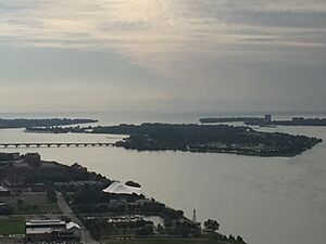
Bois Blanc Island, often called Boblo Island, is a 274-acre (1.1 square kilometer) island in the southeastern part of the Detroit River. It's the southernmost Canadian island in the river and is managed by the town of Amherstburg.
In 1836, the Bois Blanc Island Lighthouse and Blockhouse were built here to help guide ships. The island also served as a military outpost. The lighthouse stopped being used in the 1950s, but the buildings are still there. Bois Blanc Island is most famous for the Boblo Island Amusement Park, which was open from 1898 to 1993. Ferries used to bring people from Detroit to the island. There are no bridges to the mainland, but local ferries still serve the people who live in fancy homes on the north side of the island. The south side, where the amusement park used to be, is still undeveloped. You can visit the island.
Crystal Island
Crystal Island is an artificial island directly across the border from Stony Island. No one lives here, but it's part of the town of Amherstburg. Like Stony Island, it was created to make a deeper shipping lane. Its unusual shape created a beautiful area called Crystal Bay. This small bay is protected from the river's currents and pollution, making it calm and clear. While the island itself is off-limits as a nature preserve, the bay is a popular spot for boaters and fishermen.
Fighting Island
Fighting Island is the largest Canadian island in the Detroit River, at 1,500 acres (6 square kilometers). It's the second-largest island in the entire river, after Grosse Ile. It's managed by the town of LaSalle, but it's privately owned by a German company called BASF.
The island used to have a small Indigenous population. In 1918, a company bought the island and used it as a place to dump waste until at least 1982. In 1989, it was reported that most of the island was covered in very acidic waste, which even caused dust clouds to blow into nearby towns. BASF bought the company in the 1970s and has since done a huge cleanup and restoration of the island. Fighting Island is still undeveloped and is now a growing nature refuge and a place for education.
Grass Island
Grass Island is a very narrow and long island between Fighting Island and the mainland in LaSalle. No one lives on this island, and it's undeveloped. It's sometimes confused with Grassy Island, an American island on the opposite side of the river.
Peche Island
Peche Island is an 86-acre (35-hectare) island at the very beginning of the Detroit River, near Lake St. Clair. It's part of the city of Windsor. It's the easternmost island in the river and is just east of Belle Isle. Peche Island was historically known by its French names, meaning "Fisherman Island."
The island was once privately owned and used as a fancy summer home. Later owners tried to turn it into an amusement park, but those plans never happened. The island was eventually sold to the Province of Ontario and became a provincial park in 1974. The City of Windsor bought the unused island in 1999. Since then, the island has remained undeveloped and serves as a nature preserve and city park.
Turkey Island
Turkey Island is a small, uninhabited island just south of Fighting Island. It's in the town of Amherstburg. The island is privately owned, undeveloped, and you can't access it.
See also


