Hurricane Iselle facts for kids
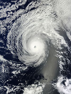
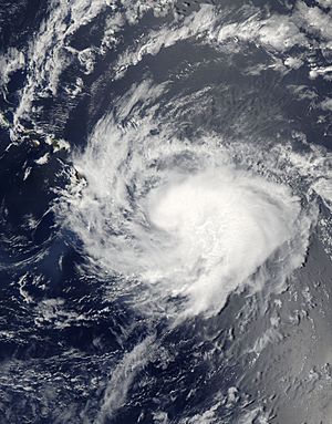
Hurricane Iselle at peak intensity with annular characteristics on August 4
|
|
| Meteorological history | |
|---|---|
| Formed | July 31, 2014 |
| Dissipated | August 11, 2014 |
| Category 4 tropical cyclone | |
| 1-minute sustained (SSHWS/NWS) | |
| Highest winds | 140 mph (220 km/h) |
| Lowest pressure | 947 mbar (hPa); 27.96 inHg |
| Overall effects | |
| Fatalities | 1 direct |
| Damage | $148 million (2014 USD) |
| Areas affected | Hawaii |
|
Part of the 2014 Pacific hurricane season |
|
Hurricane Iselle was a very powerful storm that hit the Big Island of Hawaii in 2014. It was the strongest tropical cyclone ever to make landfall there. A tropical cyclone is a big storm system with strong winds and heavy rain.
Iselle started as a small storm near Mexico on July 31, 2014. It grew stronger as it moved west. By August 4, it became a powerful Category 4 hurricane. This means its winds reached 140 miles per hour (220 km/h)! After that, Iselle started to weaken. It hit the Big Island on August 8 as a tropical storm. The storm then broke apart and disappeared a few days later.
Before Iselle hit, people in Hawaii got ready. The governor declared an emergency. Many schools and government buildings closed. Airlines also canceled flights. When the storm arrived, it caused heavy rain and strong winds. This led to widespread power outages and many trees falling down. The storm also damaged a lot of crops, especially papaya. One person on Kauai sadly died because of flooding.
Contents
How Iselle Formed and Changed
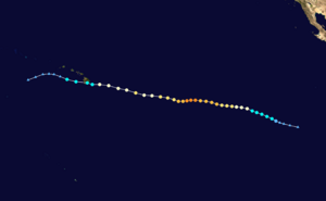
In late July 2014, weather experts saw signs of a storm forming near Mexico. On July 31, a tropical depression officially formed. A few hours later, it became Tropical Storm Iselle. It was located far southwest of the Baja California peninsula.
Iselle kept getting stronger. On August 1, it started to form an eye, which is the calm center of a hurricane. By August 2, it became a hurricane. For a short time, strong winds high in the atmosphere made the storm a bit messy. But these conditions soon went away.
The storm continued to get more organized. Its eye became clear, and on August 3, Iselle became a major hurricane. This means it was a Category 3 or stronger storm. On August 4, it reached its strongest point as a Category 4 hurricane. Its winds were 140 mph (220 km/h). The eye of the hurricane was about 30 miles (45 km) wide.
After reaching its peak strength, Iselle started to weaken. This happened because of stronger winds high up and cooler ocean water. By August 5, it was no longer a Category 4 hurricane. On August 6, it weakened to a Category 1 hurricane.
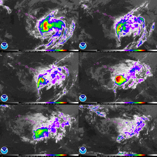
Even though it was weakening, Iselle still had a large eye as it moved toward Hawaii. It briefly got a bit stronger again on August 7, with winds of 100 mph (155 km/h). But then, strong winds high up in the atmosphere caused it to weaken quickly.
Iselle became a tropical storm on August 8. It made landfall on the Kau coast of the Big Island with winds of 60 mph (95 km/h). The tall mountains on the island broke up the storm's center. Iselle then lost its strong thunderstorms and became just a leftover area of low pressure on August 9. It finally disappeared two days later.
Getting Ready for the Storm
As Iselle got closer, weather experts issued warnings. On August 5, a tropical storm watch was issued for the island of Hawaii. This meant tropical storm conditions were possible. As the storm moved closer, hurricane warnings were issued for Hawaii County. Later, tropical storm warnings were issued for other islands like Maui and Oahu. A flash flood watch was also put in place for all the islands, meaning heavy rain and floods were possible. By August 9, all warnings were lifted.
Hawaii's governor, Neil Abercrombie, declared a state of emergency. This helped the state get ready to use resources for relief efforts. The mayor of Maui County also declared an emergency. People rushed to buy supplies like food and water.
Even though there were no forced evacuations, people in low-lying areas of Hawaii County were asked to move to higher ground. This was because of the danger of storm surge and flooding. The United States Coast Guard warned boaters about high waves and prepared to close ports.
Schools across Hawaii were closed. Many were used as emergency shelters. The University of Hawaii also closed its campuses. State parks and other natural areas were closed too. Government offices and courthouses in Hawaii County also shut down.
Airlines like Hawaiian Airlines and United Airlines allowed passengers to change their flights without extra fees. Some airlines canceled flights to Hawaii as the storm got closer. The Salvation Army also got ready to help people after the storm.
What Happened During the Storm
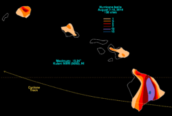
Iselle brought strong winds to most of Hawaii, except for Niihau. Winds reached 91 mph (146 km/h) on Mauna Kea on the Big Island. Heavy rains fell on the southern islands. Some parts of the Big Island got over 12 inches (300 mm) of rain. The most rain, 15.25 inches (387 mm), fell at the Hakalau Forest National Wildlife Refuge. Other areas, like Kona International Airport, got very little rain. Kauai saw over 6 inches (150 mm) of rain in some places. The storm also created big waves, 6 to 10 feet (1.8 to 3 m) high, along the eastern shores.
The strong winds damaged homes near Hilo and knocked down many trees. About 23,000 homes lost power. A geothermal power plant in Puna released toxic gases when it lost power, and people nearby were told to leave. A water treatment plant on Maui also shut down.
Iselle's winds also damaged coffee and macadamia nut trees. The papaya crop was hit the hardest, with about 60% of the state's crop destroyed. This caused about $55 million in losses. Overall, crop losses in Hawaii were estimated at $66 million.
Sadly, one 19-year-old woman died on Kauai. She was swept away by floodwaters while hiking in a closed state park. Over 250 property owners reported damage to their homes. At least 11 houses were completely destroyed, and 28 had major damage. The total cost of damage in Hawaii was estimated to be between $148 million and $325 million.
The storm also affected the primary election in Hawaii. Roads to two voting places on the Big Island were damaged. This meant people in those areas had to vote by mail. This caused some delays and discussions about the election results.
After the Storm and Records
After Iselle passed, Hawaiian Electric Industries worked hard to bring power back to the Big Island. Trucks helped clear fallen trees and debris from roads. Most customers had their power back within 12 days. However, it took about five weeks for everyone to get their power restored. Surveys showed that most of the damage came from non-native trees that broke easily in the strong winds.
People across Hawaii donated over $80,000 to help storm victims. Local charities gave out 5,000 pounds (2,268 kg) of food to over 3,000 families.
The Federal Emergency Management Agency (FEMA) looked at the damage to houses. Hawaii's governor asked for federal help because the state's disaster fund was low. At first, FEMA said no, saying there wasn't enough damage. However, the Agriculture Secretary declared an agriculture disaster, which helped farmers get loans. Later, on September 12, FEMA changed its mind and approved aid to help rebuild public buildings and prepare for future disasters.
Hurricane Iselle set some records for Hawaii. When it hit the Big Island with 60 mph (95 km/h) winds, it became the strongest tropical cyclone ever to make landfall on that island. It was one of only three storms to hit the island at tropical storm strength or higher. If Iselle had hit as a hurricane, it would have been the first hurricane ever to hit the Big Island directly.
Iselle was also one of the most expensive tropical cyclones to hit Hawaii. Its damage cost between $148 million and $325 million. Only Hurricane Iwa in 1982 and Hurricane Iniki in 1992 caused more damage to the islands. Iselle was also the third-strongest tropical cyclone to ever make landfall on the main Hawaiian islands, after hurricanes Dot and Iniki.
See also
 In Spanish: Huracán Iselle para niños
- Hurricane Gil (1983) – A hurricane that passed north of Hawaii, causing power outages and heavy rain.
- Hurricane Estelle (1986) – A hurricane that passed south of Hawaii and created big waves.
- Hurricane Daniel (2006) – A long-lasting hurricane whose leftover parts brought some flooding to Hawaii.
- Tropical Storm Flossie (2013) – A storm that moved near the Hawaiian islands from the east, bringing stormy weather.
- Hurricane Darby (2016) – A weaker tropical storm that made landfall in the same area as Iselle just two years later.
- Hurricane Olivia (2018) – A tropical storm that made landfall on the islands of Maui and Lanai.


