Ibex Pass facts for kids
Quick facts for kids Ibex Pass |
|
|---|---|

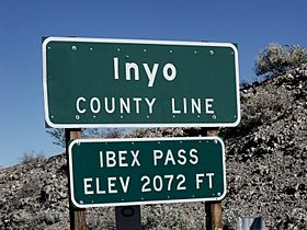
The summit of Ibex Pass
|
|
| Elevation | 2,072 ft (632 m) |
| Traversed by | |
| Location | Inyo County-San Bernardino County, California border, US |
| Range | Sperry Hills |
| Coordinates | 35°47′40″N 116°20′26″W / 35.7943115°N 116.3404566°W |
Ibex Pass [el. 2,072 ft (632 m)] is a mountain pass in the Sperry Hills of Central-Southern California in the United States.
The pass is at the summit in a range of desert hills between the Baker area and the Shoshone area and is located on the border of Inyo County and San Bernardino County. The pass connects Interstate 15 with access to Death Valley National Park, and it is traversed by State Route 127.

All content from Kiddle encyclopedia articles (including the article images and facts) can be freely used under Attribution-ShareAlike license, unless stated otherwise. Cite this article:
Ibex Pass Facts for Kids. Kiddle Encyclopedia.