
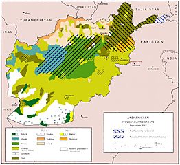
Image: US Army ethnolinguistic map of Afghanistan -- circa 2001-09

Size of this preview: 655 × 600 pixels. Other resolutions: 262 × 240 pixels | 2,319 × 2,123 pixels.
Original image (2,319 × 2,123 pixels, file size: 918 KB, MIME type: image/jpeg)
Description: US Army ethnolinguistic map of Afghanistan -- circa 2001-09.
Title: US Army ethnolinguistic map of Afghanistan -- circa 2001-09
Credit: http://www.army.mil/cmh/brochures/Afghanistan/Operation%20Enduring%20Freedom.htm
Author: Unknown
Usage Terms: Public domain
License: Public domain
Attribution Required?: No
Image usage
The following 20 pages link to this image:
- Afghanistan
- Daykundi Province
- Demographics of Afghanistan
- Demography of Afghanistan
- Faryab Province
- Hazara people
- Hazaristan
- Helmand Province
- Islamic Emirate of Afghanistan
- Jowzjan Province
- Kunar Province
- Kunduz
- Kunduz Province
- Nangarhar Province
- Nuristan Province
- Paktia Province
- Paktika Province
- Panjshir Province
- Takhar Province
- Zabul Province

All content from Kiddle encyclopedia articles (including the article images and facts) can be freely used under Attribution-ShareAlike license, unless stated otherwise.