Injune facts for kids
Quick facts for kids InjuneQueensland |
|||||||||||||||
|---|---|---|---|---|---|---|---|---|---|---|---|---|---|---|---|

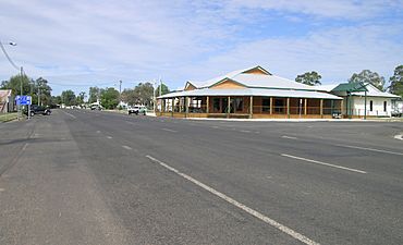
The information centre at Injune
|
|||||||||||||||
| Population | 429 (2021 census) | ||||||||||||||
| • Density | 1.0435/km2 (2.703/sq mi) | ||||||||||||||
| Postcode(s) | 4454 | ||||||||||||||
| Elevation | 393 m (1,289 ft) | ||||||||||||||
| Area | 411.1 km2 (158.7 sq mi) | ||||||||||||||
| Time zone | AEST (UTC+10:00) | ||||||||||||||
| Location | |||||||||||||||
| LGA(s) | Maranoa Region | ||||||||||||||
| State electorate(s) | Warrego | ||||||||||||||
| Federal Division(s) | Maranoa | ||||||||||||||
|
|||||||||||||||
|
|||||||||||||||
Injune is a small rural town in Queensland, Australia. It is located in the Maranoa Region. In 2021, about 429 people lived in Injune. It's known as a gateway to the amazing Carnarvon National Park.
Contents
Discovering Injune's Location
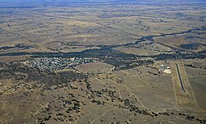
Injune is found in South West Queensland. It sits right on the Carnarvon Highway. The town is about 92 kilometers (57 miles) north of Roma, a larger regional center.
Injune used to be a big center for raising cattle and producing dairy products. Today, it's a popular starting point for trips to the nearby Carnarvon National Park. The town also has important industries like natural gas and timber.
A Look Back at Injune's History
How Injune Got Its Name
The name Injune likely comes from an Aboriginal word, "Ingon." This word refers to a type of flying squirrel or sugar glider that is common in the area.
Early Days and the Railway
Injune's Post Office opened its doors on August 11, 1920. Soon after, Injune State School welcomed its first students on October 24, 1921.
A railway line connected Injune to Roma for many years. It first opened in 1916, reaching Injune in 1920. This railway was very important for transporting goods. However, keeping the many bridges along the line in good repair became too expensive. The last train left Injune on December 31, 1966, and the line was closed. By mid-1968, all the railway tracks and buildings were removed.
Learning in Injune
Injune P-10 State School is the main school in town. It teaches students from Prep (the first year of school) all the way up to Year 10. The school is for both boys and girls. It is located on the corner of Hutton Street and Fourth Avenue.
Since Injune State School only goes up to Year 10, students who want to continue their education for Years 11 and 12 usually go to Roma State College. This college is located in Roma, to the south of Injune.
Things to Do and See in Injune
Injune's Public Library
Injune has a public library on Hutton Street. It is run by the Maranoa Regional Council. It's a great place to find books and learn new things.
Art and Culture in Injune
People in the Injune area love art! A local art group called the Injune Public Space Art Group (IPSAG) is working to create Henricks Park. This park will be a special place for art and sculptures. It is located across from the Injune Information Centre.
The Historic Steam Train
Injune has a special area dedicated to its railway history. You can see Locomotive No. 824 there. This train was involved in a famous railway accident in 1947, but it was repaired and put back into service. It worked in South East Queensland for many years. In 1958, it moved to Toowoomba.
The locomotive was taken out of service in May 1967. It was then given to the local council and brought to Injune. Today, it is a historical steam train attraction. You can find it behind the town's ambulance station.
Injune's Climate
Injune has a subtropical climate. This means it has warm to hot summers. The winters are cool. Most of the rain falls during the summer months.
Injune has experienced some very cold temperatures. A record low of -8.0 degrees Celsius (-17.6 degrees Fahrenheit) was recorded here. This is one of the coldest temperatures ever recorded in Queensland outside of the Darling Downs and Granite Belt region. A similar record low was also set in nearby Mitchell.
| Climate data for Injune | |||||||||||||
|---|---|---|---|---|---|---|---|---|---|---|---|---|---|
| Month | Jan | Feb | Mar | Apr | May | Jun | Jul | Aug | Sep | Oct | Nov | Dec | Year |
| Record high °C (°F) | 43.8 (110.8) |
42.2 (108.0) |
40.1 (104.2) |
35.9 (96.6) |
33.3 (91.9) |
30.0 (86.0) |
34.2 (93.6) |
36.1 (97.0) |
39.3 (102.7) |
40.5 (104.9) |
42.4 (108.3) |
44.1 (111.4) |
44.1 (111.4) |
| Mean daily maximum °C (°F) | 33.6 (92.5) |
32.1 (89.8) |
30.8 (87.4) |
27.7 (81.9) |
23.4 (74.1) |
20.3 (68.5) |
20.0 (68.0) |
22.3 (72.1) |
26.1 (79.0) |
29.4 (84.9) |
31.4 (88.5) |
33.1 (91.6) |
27.5 (81.5) |
| Mean daily minimum °C (°F) | 19.6 (67.3) |
19.1 (66.4) |
16.4 (61.5) |
11.9 (53.4) |
7.7 (45.9) |
4.5 (40.1) |
3.1 (37.6) |
4.4 (39.9) |
8.1 (46.6) |
12.7 (54.9) |
15.9 (60.6) |
18.1 (64.6) |
11.8 (53.2) |
| Record low °C (°F) | 10.6 (51.1) |
9.4 (48.9) |
3.6 (38.5) |
−0.8 (30.6) |
−4.4 (24.1) |
−6.7 (19.9) |
−8.0 (17.6) |
−6.2 (20.8) |
−3.3 (26.1) |
−0.4 (31.3) |
3.1 (37.6) |
6.6 (43.9) |
−8.0 (17.6) |
| Average rainfall mm (inches) | 88.9 (3.50) |
88.8 (3.50) |
62.2 (2.45) |
41.8 (1.65) |
33.3 (1.31) |
30.3 (1.19) |
29.3 (1.15) |
25.2 (0.99) |
26.0 (1.02) |
47.2 (1.86) |
72.4 (2.85) |
89.1 (3.51) |
634.5 (24.98) |
| Average rainy days (≥ 0.2mm) | 7.7 | 7.0 | 5.3 | 3.9 | 3.9 | 3.9 | 3.6 | 3.3 | 3.7 | 5.9 | 7.0 | 8.2 | 63.4 |
| Source: Bureau of Meteorology | |||||||||||||
 | Bessie Coleman |
 | Spann Watson |
 | Jill E. Brown |
 | Sherman W. White |


