
Inver Grove Heights, Minnesota facts for kids
Quick facts for kids
Inver Grove Heights, Minnesota
|
|
|---|---|
 |
|
| Nickname(s):
Inver Grove
|
|

Location of Inver Grove Heights, Minnesota
|
|
| Country | United States |
| State | Minnesota |
| County | Dakota |
| Established | 1852 |
| Incorporated | March 9, 1965 |
| Government | |
| • Type | Weak Mayor–Council |
| Area | |
| • Total | 30.22 sq mi (78.27 km2) |
| • Land | 27.85 sq mi (72.14 km2) |
| • Water | 2.37 sq mi (6.13 km2) |
| Elevation | 879 ft (268 m) |
| Population
(2020)
|
|
| • Total | 35,801 |
| • Estimate
(2022)
|
35,701 |
| • Density | 1,285.31/sq mi (496.25/km2) |
| Time zone | UTC-6 (Central) |
| • Summer (DST) | UTC-5 (CDT) |
| ZIP codes |
55076, 55077
|
| Area code(s) | 651 |
| FIPS code | 27-31076 |
| GNIS feature ID | 0645437 |
Inver Grove Heights is a city in Dakota County, Minnesota, United States. It is home to over 35,000 people. The city was created on March 9, 1965. This happened when the village of Inver Grove and Inver Grove Township joined together.
Inver Grove Heights is part of the large Minneapolis-Saint Paul area. It is about 9 miles (14 km) southeast of Saint Paul. Other nearby towns include South St. Paul and Eagan.
Contents
History of Inver Grove Heights
.jpg)
After a special agreement called the Treaty of Traverse des Sioux in 1851, many new people moved here. Settlers from Ireland and Germany quickly claimed land. Irish families farmed the eastern part of the area. German families cleared forests in the west for their farms. People from France and England also built homes along the Mississippi River.
The name "Inver Grove Heights" comes from two places. "Inver" is an Irish fishing village. "Grove" is a town in Germany. By 1880, there were 240 farms, four churches, and four school districts. On March 9, 1965, the village and township officially merged. This formed the city we know today.
Historic Places to Explore
Inver Grove Heights has several important historic sites:
- Chief Medicine Bottle's Village: This village was formed in 1836. It later became the Pine Bend village and post office.
- Mendota-Wabasha Road: This was a military road built in 1853. Today, Rich Valley Road follows its path.
- District 7 School: This was the very first public school in Dakota County. It opened in 1854.
- Salem United Methodist Church: This church was started in 1854.
- Old Emanuel Lutheran Church: The first log church was built here in 1854. Services were held in German.
- Church of St. Patrick: This Catholic church parish was started on January 9, 1856.
- Salem Evangelical Church: This was the first group of its kind in Minnesota. It was organized on March 2, 1857.
- Josiah Burwell's House: Inver Grove Township was first organized here in 1858. It is located at Rich Valley Road and 102nd Street.
- Reuben Freeman House: This unique house with eight gables was built in 1876.
- Inver Grove Town Hall: The first town hall building was built in 1878.
- Inver Grove Village railway depot: This train station was built in 1886.
- Rock Island Swing Bridge: This bridge was built in 1894. It crossed the Mississippi River. It closed to trains in 1980 and cars in 1999. It reopened as a park in 2011.
- Duke's Restaurant: Built in 1906, it was first a butcher shop. It later became a restaurant for railway workers.
- B-52 Crash Site: On September 16, 1958, a U.S. Air Force B-52 bomber crashed here. Seven crew members died during a training mission. There is a marker on Broderick near West Loop Court.
Geography and Landscape
Inver Grove Heights covers about 30.12 square miles (78.01 square kilometers). Most of this area is land, about 27.76 sq mi (71.90 sq km). The rest, about 2.36 sq mi (6.11 sq km), is water.
Main Roads and Highways
Several major roads pass through Inver Grove Heights. These include:
- Interstate Highway 494: This is a beltway that goes around Minneapolis–Saint Paul.
- U.S. Highway 52
- Minnesota Highway 55
- Minnesota Highway 3
80th Street East also crosses the city from east to west.
Pine Bend Impact Crater
In 2022, scientists found something amazing. A meteoric impact crater was identified in the Pine Bend Bluffs area. It has been unofficially named the "Pine Bend impact." This crater is about four kilometers wide. It is estimated to be 500 million years old!
Population and People
| Historical population | |||
|---|---|---|---|
| Census | Pop. | %± | |
| 1860 | 646 | — | |
| 1870 | 971 | 50.3% | |
| 1880 | 791 | −18.5% | |
| 1890 | 1,211 | 53.1% | |
| 1900 | 1,402 | 15.8% | |
| 1910 | 1,384 | −1.3% | |
| 1920 | 1,573 | 13.7% | |
| 1930 | 1,617 | 2.8% | |
| 1940 | 1,887 | 16.7% | |
| 1950 | 2,419 | 28.2% | |
| 1960 | 6,266 | 159.0% | |
| 1970 | 12,148 | 93.9% | |
| 1980 | 17,171 | 41.3% | |
| 1990 | 22,477 | 30.9% | |
| 2000 | 29,751 | 32.4% | |
| 2010 | 33,880 | 13.9% | |
| 2020 | 35,801 | 5.7% | |
| 2022 (est.) | 35,701 | 5.4% | |
| U.S. Decennial Census 2020 Census Note: Inver Grove and Inver Grove Township were merged in 1965 to form Inver Grove Heights. |
|||
The census helps us understand the population. In 2010, there were 33,880 people living in Inver Grove Heights. By 2020, the population grew to 35,801.
Most residents, about 85.7%, were White in 2010. Other groups included African American (3.8%), Asian (3.4%), and Native American (0.4%). About 8.9% of the population was Hispanic or Latino.
The average age in the city was 38.4 years. About 24.5% of people were under 18 years old. This means many young people live in Inver Grove Heights!
Economy and Jobs
In 2007, about 11,158 people worked in Inver Grove Heights. The city is home to some big companies.
Major Companies in Inver Grove Heights
- CHS, Inc. is headquartered here. It's a large agricultural cooperative. This means it's a business owned and run by its members, often farmers. It helps them sell their products.
- Pine Bend Refinery is a very large oil refinery. It processes crude oil into products like gasoline. It's one of the biggest in Minnesota.
- Gertens Greenhouses is also located here. It's one of the largest garden centers in the United States.
Top Employers in the City
Here are some of the biggest employers in Inver Grove Heights, based on a 2021 report:
| # | Employer | # of Employees |
|---|---|---|
| 1 | Cenex / CHS Cooperatives | 1,600 |
| 2 | ISD 199 (Inver Grove Heights Community Schools) | 668 |
| 3 | Gertens | 435 |
| 4 | City of Inver Grove Heights | 421 |
| 5 | Travel Tags | 350 |
| 6 | Inver Hills Community College | 337 |
| 7 | Total Construction and Equipment | 250 |
| 8 | Walmart | 210 |
| 9 | Woodlyn Heights Senior Living | 200 |
| 10 | Cub Foods | 160 |
Education for Students
The Inver Grove Heights Community Schools district (ISD 199) runs five schools in the city:
- Simley High School
- Inver Grove Heights Middle School
- Hilltop Elementary School
- Pine Bend Elementary School
- Salem Hills Elementary School
There is also one private school for younger students. It is called Berea Lutheran Church. Some students in the western part of the city attend schools in a different district, ISD 196. These include Eagan High School and Rosemount High School.
Inver Grove Heights is also home to Inver Hills Community College. This college offers many programs for students after high school.
Sports and Fun Activities
Inver Grove Heights has many places for sports and recreation.
- Golf Courses: You can play golf at Inver Wood Golf Course and Arbor Pointe Golf Club.
- Disc Golf: There's also an 18-hole disc golf course called North Valley.
- Community Center: The city has a public community center. It features a waterpark, two ice rinks, and a full gym. This gym is also shared with the National Guard.
Images for kids
-
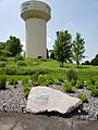
B-52 Crash Site memorial with Inver Grove Heights water tower in the background
-
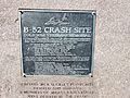
Plaque commemorating those who died in the B-52 crash
-
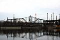
Rock Island Swing Bridge in 2008
-

Rock Island Swing Bridge Park
-
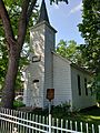
Salem Evangelical Church
-
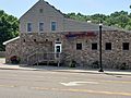
Former Duke's Restaurant location, now Jersey's Bar and Grill
-
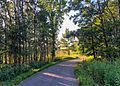
Bike Trail in Inver Grove Heights
-
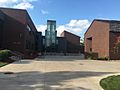
Inver Hills Fine Arts Building


.jpg)

See also
 In Spanish: Inver Grove Heights (Minnesota) para niños
