Irasburg, Vermont facts for kids
Quick facts for kids
Irasburg, Vermont
|
|
|---|---|
|
Town
|
|

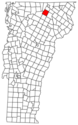
Located in Orleans County, Vermont
|
|

Location of Vermont with the U.S.A.
|
|
| Country | United States |
| State | Vermont |
| County | Orleans |
| Chartered | February 23, 1781 |
| Communities | |
| Area | |
| • Total | 40.6 sq mi (105.1 km2) |
| • Land | 40.5 sq mi (105.0 km2) |
| • Water | 0.1 sq mi (0.2 km2) |
| Elevation | 814 ft (313 m) |
| Population
(2020)
|
|
| • Total | 1,233 |
| • Density | 30/sq mi (11.7/km2) |
| • Households | 501 |
| • Families | 379 |
| Time zone | UTC-5 (EST) |
| • Summer (DST) | UTC-4 (EDT) |
| ZIP Codes | |
| Area code | 802 |
| FIPS code | 50-35575 |
| GNIS feature ID | 1462124 |
Irasburg is a town in Orleans County, Vermont, United States. It was created in 1781. The land was given to Ira Allen and others by the Vermont General Assembly. Ira Allen later owned most of the land. He gave the town to Jerusha Enos, Jr. as a wedding gift.
In 2020, there were 1,233 people living in Irasburg. The town covers about 40.6 square miles (105 km2) of land. Only .1 square miles (0.26 km2) is water. The small village of Irasburg is located in the center of the town.
Contents
History of Irasburg
The land for Irasburg was officially granted on February 23, 1781. It was given to Ira Allen by the General Assembly of Vermont. At that time, both New Hampshire and New York claimed the lands of Vermont. The Continental Congress said no land should be given out until this argument was settled. However, Vermont's General Assembly did not follow this order.
Ira Allen was born in 1790. He went to Middlebury College and the University of Vermont. The Allen family rented out the land they received to people who wanted to settle there. Even though Ira Allen was granted the land first, the first person to actually settle in Irasburg was Caleb Leach in 1798.
Captain James Richardson settled in Irasburg in 1803. He is thought to have opened the first tavern in town.
Early Industries and Smuggling
In the early 1800s, making salts and pearl-ashes was the main business in Irasburg. Even with an embargo (a ban on trade), these goods were secretly taken to Canada. Many town residents were involved in smuggling these products.
Mills started appearing in Irasburg around 1810. By the 1820s, the town began to grow. New factories opened, including a woolen mill and a tannery. They also made stoves and plows. The Old Heerman Mill was also located here.
Irasburg as a Shire Town
In 1812, the state government decided to make Irasburg the main town (shire town) for Orleans County. This meant it was the county seat. Buildings to support this, like a courthouse, were finished in 1816.
Irasburg remained the shire town until 1886. Then, the state government moved the county seat to Newport.
The first courthouse and jail were built in 1815. Local residents paid for them. The original courthouse was moved in 1847, and a new one was built in its place. The first jail was made of wood. It was replaced by a stone one in 1838, and then a granite one in 1862.
In 1862, some soldiers for Company E of the 9th Vermont Infantry were recruited from Irasburg.
In 1877, the town's name was still spelled "Irasburgh."
The original county courthouse burned down in 1910 or 1911. All its records were lost. A new Irasburg Town Hall was built in 1911. It was updated in 1990.
In 2010, Irasburg was in the news because of a moose. The moose was going to be put down because it was "tamed," which is not allowed for wild animals in Vermont. The Vermont Legislature created a special law to save the moose's life.
Geography of Irasburg
Irasburg covers about 40.6 square miles (105 km2) (105.1 square kilometres (40.6 sq mi)) in total. Most of this is land, about 40.5 square miles (105 km2) (105.0 square kilometres (40.5 sq mi)). Only a small part, 0.1 square miles (0.26 km2) (0.2 square kilometres (0.077 sq mi)), is water.
Rivers and Streams
The Black River flows through Irasburg towards the north. Many small streams join it. It enters the town east of Potters Pond. It then flows northeast, then east, reaching the village of Irasburg. Just before the village, Lords Creek joins the Black River. Lords Creek is about 10 miles (16 km) long.
After leaving the town of Orleans, the Barton River flows through the eastern part of Irasburg. It then goes into the town of Coventry.
Climate and Weather
Irasburg has never had temperatures higher than 98 °F (37 °C). July is the hottest month, with an average high temperature of just over 80 °F (27 °C). The coldest temperature ever recorded was −40 °F (−40 °C) in December.
It snows in Irasburg about 9 out of 12 months each year. Most of the snow falls between November and March. During these months, Irasburg gets over 10 inches (250 mm) of snow on average. The town gets about 103 inches (2,600 mm) of snow every year.
| Climate data for Newport, Vermont | |||||||||||||
|---|---|---|---|---|---|---|---|---|---|---|---|---|---|
| Month | Jan | Feb | Mar | Apr | May | Jun | Jul | Aug | Sep | Oct | Nov | Dec | Year |
| Record high °F (°C) | 64 (18) |
62 (17) |
83 (28) |
87 (31) |
92 (33) |
95 (35) |
98 (37) |
95 (35) |
96 (36) |
84 (29) |
74 (23) |
66 (19) |
98 (37) |
| Mean daily maximum °F (°C) | 26.3 (−3.2) |
31.0 (−0.6) |
41.0 (5.0) |
54.2 (12.3) |
69.0 (20.6) |
76.8 (24.9) |
80.9 (27.2) |
78.8 (26.0) |
69.5 (20.8) |
57.0 (13.9) |
43.1 (6.2) |
31.0 (−0.6) |
54.9 (12.7) |
| Mean daily minimum °F (°C) | 5.5 (−14.7) |
7.8 (−13.4) |
18.7 (−7.4) |
31.3 (−0.4) |
43.2 (6.2) |
52.4 (11.3) |
56.8 (13.8) |
54.8 (12.7) |
46.8 (8.2) |
37.0 (2.8) |
27.3 (−2.6) |
13.0 (−10.6) |
32.9 (0.5) |
| Record low °F (°C) | −38 (−39) |
−38 (−39) |
−32 (−36) |
−2 (−19) |
20 (−7) |
28 (−2) |
36 (2) |
32 (0) |
20 (−7) |
0 (−18) |
−7 (−22) |
−40 (−40) |
−40 (−40) |
| Average precipitation inches (mm) | 2.96 (75) |
2.16 (55) |
2.96 (75) |
2.93 (74) |
3.67 (93) |
3.93 (100) |
4.19 (106) |
4.18 (106) |
3.76 (96) |
3.45 (88) |
3.47 (88) |
3.12 (79) |
40.78 (1,035) |
| Average snowfall inches (cm) | 24.7 (63) |
17.2 (44) |
18.8 (48) |
6.9 (18) |
0.1 (0.25) |
0 (0) |
0 (0) |
0 (0) |
01 (2.5) |
1.1 (2.8) |
11.0 (28) |
23.1 (59) |
102.9 (261) |
| Source: NOAA | |||||||||||||
People Living in Irasburg
| Historical population | |||
|---|---|---|---|
| Census | Pop. | %± | |
| 1800 | 15 | — | |
| 1810 | 292 | 1,846.7% | |
| 1820 | 432 | 47.9% | |
| 1830 | 860 | 99.1% | |
| 1840 | 971 | 12.9% | |
| 1850 | 1,034 | 6.5% | |
| 1860 | 1,131 | 9.4% | |
| 1870 | 1,085 | −4.1% | |
| 1880 | 1,064 | −1.9% | |
| 1890 | 999 | −6.1% | |
| 1900 | 939 | −6.0% | |
| 1910 | 983 | 4.7% | |
| 1920 | 999 | 1.6% | |
| 1930 | 924 | −7.5% | |
| 1940 | 852 | −7.8% | |
| 1950 | 711 | −16.5% | |
| 1960 | 711 | 0.0% | |
| 1970 | 775 | 9.0% | |
| 1980 | 870 | 12.3% | |
| 1990 | 907 | 4.3% | |
| 2000 | 1,077 | 18.7% | |
| 2010 | 1,163 | 8.0% | |
| 2020 | 1,233 | 6.0% | |
| U.S. Decennial Census | |||
In 2010, there were 1,096 people living in Irasburg. There were 452 households and 318 families. Most people (96.6%) were White.
About 27.9% of households had children under 18 living with them. Most households (56.4%) were married couples. The average household had 2.42 people. The average family had 2.81 people.
The median age for males was 42 years old. For females, it was 44.4 years old.
Fun Events in Irasburg
Annual Foot Race
The Kingdom run is an annual foot race. It happens every summer. The race starts and ends in the Irasburg town commons. Runners can choose to race 5 kilometres (3.1 mi), 10 kilometres (6.2 mi), or 20 kilometres (12 mi).
Irasburg Church Fair
The annual Irasburg Church Fair began in 1952. This fair includes an auction. You can also buy delicious baked goods there.
Landmarks to See
There used to be a round barn on Vermont Route 58. It was about 1.5 miles (2.4 km) west of the village. Sadly, this historic barn was destroyed by a fire on August 23, 2016.
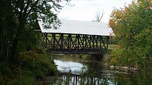
The Lord's Creek Covered Bridge was built in 1881. You can find it on Covered Bridge Road.
Famous People from Irasburg
- Elias P. Bailey: He was a member of the Wisconsin State Assembly.
- Henry M. Bates: He served as the Vermont State Treasurer.
- Howard Frank Mosher: A well-known author.
- Theodore Robinson: An impressionist painter known for landscapes.
- Frank D. Thompson: An Associate Justice of the Vermont Supreme Court.
- Laforrest H. Thompson: He was the President of the Vermont State Senate. He also served as a Justice of the Vermont Supreme Court.
See also
 In Spanish: Irasburg para niños
 | Sharif Bey |
 | Hale Woodruff |
 | Richmond Barthé |
 | Purvis Young |


