John Redmond Reservoir facts for kids
Quick facts for kids John Redmond Reservoir |
|
|---|---|
| Location | Coffey County, Kansas |
| Coordinates | 38°15′05″N 95°48′10″W / 38.2515043°N 95.8029017°W |
| Type | Reservoir |
| Primary inflows | Neosho River |
| Primary outflows | Neosho River |
| Catchment area | 3,015 sq mi (7,810 km2) |
| Basin countries | United States |
| Managing agency | U.S. Army Corps of Engineers |
| Built | June 18, 1959 |
| First flooded | November 17, 1964 |
| Surface area | 9,400 acres (38 km2) |
| Max. depth | 12 ft (3.7 m) |
| Water volume | Full: 67,302 acre⋅ft (83,016,000 m3) Current (Jan. 2016): 88,024 acre⋅ft (108,576,000 m3) |
| Shore length1 | 59 miles (95 km) |
| Surface elevation | Full: 1,041 ft (317 m) Current (Jan. 2016): 1,043 ft (318 m) |
| Islands | 3 on South section |
| Settlements | Burlington, New Strawn, Ottumwa |
| 1 Shore length is not a well-defined measure. | |
The John Redmond Reservoir is a large, man-made lake in eastern Kansas. It was built on the Neosho River. The U.S. Army Corps of Engineers built and now manages this reservoir.
This important lake helps control floods, provides water, and offers fun outdoor activities. It is also a home for many different animals. The reservoir is next to the Flint Hills National Wildlife Refuge.
Contents
History of John Redmond Reservoir
The area around the Neosho River used to flood very often. In just 30 years before 1950, the valley flooded more than 50 times! Because of this, the U.S. Congress decided to approve a project to control the floods. This project later became the John Redmond Dam and Reservoir.
The project was approved before the Great Flood of 1951. This huge flood covered downtown Burlington and Strawn. In some places, the floodwater was 30 feet (9.1 m) deep!
Why the Name Changed
The project was first called Strawn Dam. This was because the town of Strawn was located where the reservoir is now. When the dam was built, Strawn was moved about 6 miles (9.7 km) east to higher ground. It was then renamed New Strawn.
In 1958, Congress decided to rename the project. They chose John Redmond Dam and Reservoir. This was to honor John Redmond, who published the Burlington Daily Republican newspaper. He had worked for a long time to help control floods and save water along the Neosho River. John Redmond passed away in 1953.
Building the Dam
The U.S. Army Corps of Engineers in Tulsa designed and built the project. It cost about $29,264,000 in total. Construction on the dam began on June 18, 1959.
The dam started working on November 17, 1964. This was a few weeks before it was completely finished. It was put into service early to protect the Neosho River valley from floods expected that winter and spring.
During the Great Flood of 1993, the water in the reservoir reached the top of the dam's release gates. The reservoir became completely full in July 1993. This meant that water had to be released through the spillway for the very first time.
Where is John Redmond Reservoir?
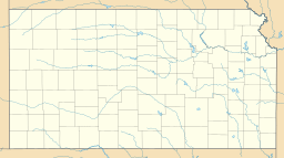
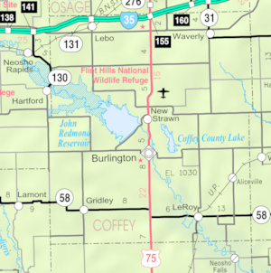
John Redmond Reservoir is located in east-central Kansas. It sits east of the Flint Hills in an area called the Osage Plains. The entire reservoir is located within Coffey County.
Water Flow
The lake is held back at its southeastern end by the John Redmond Dam. The Neosho River flows into the reservoir from the northwest. It also flows out of the reservoir to the southeast.
Smaller streams that flow into the reservoir include Hickory Creek and Kennedy Creek from the north. Buffalo Creek and Otter Creek also flow in from the west.
Nearby Towns and Roads
U.S. Route 75 runs north and south to the east of the reservoir. 12th Road, a paved county road, runs east and west south of the reservoir. Another paved county road, Embankment Road, runs along the top of the dam.
Several towns are located near the reservoir. The largest town, Burlington, is about 2 miles (3.2 km) southeast of the dam. New Strawn is right next to the reservoir on the east side of the dam. Ottumwa, which is a small, unincorporated community, is on the north shore of the reservoir.
How Big is the Reservoir?
The size of the reservoir changes depending on how much water flows in and the weather. The Corps of Engineers divides the reservoir into different "pools" based on how much water they hold.
When the reservoir is full to its normal level (called the conservation pool), it covers about 9,400 acres (38 km2). At this level, the water is about 1,041 feet (317 m) high. It holds about 67,302 acre-feet (83,016,000 m3) of water.
When the reservoir is completely full (at its maximum capacity), the water level can reach 1,073 feet (327 m). At this point, it holds a huge amount of water: 755,330 acre-feet (931,690,000 m3). The bottom of the reservoir, where the old riverbed is, is about 995 feet (303 m) high.
How the Dam Works
The John Redmond Dam is an earth-fill embankment dam. This means it's made mostly of earth and rock. It stands 86.5 feet (26.4 m) tall above the riverbed and is 21,790 feet (6,640 m) long. The very top of the dam is 1,081.5 feet (329.6 m) high.
The Spillway
A 664-foot (202 m) section of the dam on its northeast end is a concrete spillway. A spillway is like a giant overflow channel. It lets extra water out into the Neosho River. This spillway has 14 large tainter gates, each 40-foot (12 m) by 35-foot (11 m).
When the reservoir is at its maximum capacity, the spillway can release 578,000 cubic feet per second (16,400 m3/s) of water. There are also two smaller pipes, 24-inch (61 cm) wide, that can release 130 cubic feet per second (3.7 m3/s) of water.
Power Plant Connection
An intake building for the Wolf Creek Generating Station is located below the dam. This building helps provide a backup cooling source for the power plant. The river channel below the dam can handle up to 15,000 cubic feet per second (420 m3/s) of water.
Managing the Reservoir
The U.S. Army Corps of Engineers (Tulsa District) manages John Redmond Dam and Reservoir. They make sure it helps with flood control, provides water, keeps water quality good, and offers recreation. The Corps also looks after the fun activities on the lake and in the parks around it.
Wildlife Areas
The U.S. Fish and Wildlife Service manages a large area of land, 18,463 acres (74.72 km2), along the river northwest of the reservoir. This area is called the Flint Hills National Wildlife Refuge. It's a special place for wildlife.
The Corps of Engineers has also allowed the Kansas Department of Wildlife, Parks and Tourism (KDWP) to manage 1,637 acres (6.62 km2) on the reservoir's southwest shore. This area is called the Otter Creek Wildlife Area. It includes different types of land, like 200 acres (81 ha) of land along the river, 465 acres (188 ha) of farmland, and 970 acres (390 ha) of natural grasslands.
Water Supply for Power
John Redmond Reservoir also serves as a backup water supply for the Wolf Creek Generating Station. This power plant is about 5 miles (8.0 km) east of the reservoir. When the power plant was built, another lake, Coffey County Lake, was created as its main water source. Water is pumped from John Redmond Reservoir to Coffey County Lake when needed to keep its water level high enough.
Fun at John Redmond Reservoir
The Corps of Engineers manages three parks at the reservoir for visitors to enjoy. These are Dam Site Park, Riverside East Park, and Riverside West Park. Dam Site Park is on the eastern shore, at the northeast end of the dam. Riverside East Park and Riverside West Park are right below the dam, on both sides of the Neosho River.
Activities and Facilities
Both Dam Site and Riverside West parks have boat ramps, so you can easily launch your boat. Dam Site and Riverside East parks also have hiking trails for exploring. All three parks offer places for camping and picnics.
The Corps also manages three other recreation areas with boat ramps:
- The Otter Creek Recreational Area is on the western shore, at the southwest end of the dam. This 240 acres (97 ha) area is open for off-road vehicles.
- The Strawn and Hartford Areas are located upstream within the Flint Hills Wildlife Refuge.
Lastly, the Corps manages the Hickory Creek trail on the north shore of the reservoir. This trail is great for hiking, horseback riding, and mountain biking.
Fishing and Hunting
John Redmond Reservoir is a popular spot for sport-fishing. You can also hunt on the public land around the reservoir, including in the Flint Hills Refuge, but there are rules you need to follow.
Wildlife at the Reservoir
The reservoir and the land around it are home to many animals.
Fish Species
You can find different types of fish in the reservoir, including:
One type of invasive species, the zebra mussel, is also present in the reservoir.
Land Animals
On the land around the reservoir, you might see game animals such as:
- Bobwhite quail
- Cottontail rabbits
- Mourning doves
- Prairie chickens
- Squirrels
- Turkeys
- Whitetail deer
 | Claudette Colvin |
 | Myrlie Evers-Williams |
 | Alberta Odell Jones |


