Joppatowne, Maryland facts for kids
Quick facts for kids
Joppatowne, Maryland
|
|
|---|---|

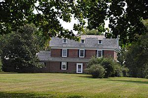
Benjamin Rumsey Mansion in 2008
|
|

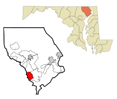
Location of Joppatowne, Maryland
|
|
| Country | United States |
| State | Maryland |
| County | Harford |
| Area | |
| • Total | 7.39 sq mi (19.13 km2) |
| • Land | 6.73 sq mi (17.43 km2) |
| • Water | 0.66 sq mi (1.70 km2) |
| Elevation | 239 ft (73 m) |
| Population
(2020)
|
|
| • Total | 13,425 |
| • Density | 1,995.10/sq mi (770.33/km2) |
| Time zone | UTC−5 (Eastern (EST)) |
| • Summer (DST) | UTC−4 (EDT) |
| ZIP code |
21085
|
| Area code(s) | 410 |
| FIPS code | 24-42875 |
Joppatowne is a community located in southwestern Harford County, Maryland, United States. It's a place where many people live and then travel to work in nearby cities like Baltimore. Joppatowne was started in 1961 as a carefully planned community. In 2020, about 13,425 people lived there.
The name "Joppatowne" comes from an older town called "Joppa." This original Joppa was a very important seaport during America's colonial times. It was even the main town for Baltimore County until 1768. The site of this old town is actually within what is now Joppatowne.
Contents
Joppatowne's Early History
Before modern Joppatowne, there were three other towns in the area. Each one was built and then later left behind. These towns were Gunpowder Town, Foster's Neck, and the original Joppa.
Gunpowder Town: A Lost Settlement
Gunpowder Town was an early English settlement that didn't last long. It was located near the Gunpowder River. People think it was abandoned because it wasn't a good place to build a town. Even though old papers mention it, no one knows exactly where it was.
Foster's Neck: A Short-Lived Town
In 1706, another town called "Foster's Neck" was started nearby. It was on the eastern side of the Gunpowder River. This town was supposed to become the main town for Baltimore County. However, it was abandoned just one year later, in 1707. This happened because of a serious illness called smallpox.
Joppa: A Thriving Colonial Seaport
The original Joppa was a very important seaport and trading center in the 1700s. It was located where two rivers, the Big Gunpowder Falls and Little Gunpowder Falls, meet. The only old building still standing from that time is the Rumsey Mansion. This mansion was once home to a famous colonial leader named Benjamin Rumsey.
Joppa was the main town for Baltimore County from 1712 to 1769. Back then, Harford County was part of Baltimore County. Joppa's wide harbor could fit large ships coming from the ocean. It was Maryland's most important trading spot, especially for tobacco. It was one of the busiest seaports in the western part of the world, even before Baltimore City was founded.
Joppa was also a key place for land travel. Many roads led to Joppa, connecting it to places like Towson and York, Pennsylvania. Important people from colonial times often passed through Joppa. Businesses also grew north of Joppa, using water power from the Little Gunpowder Falls. One example is the Jerusalem Mill Village, which made weapons for the American army during the Revolutionary War.
By the late 1700s, the Gunpowder River began to fill with dirt and mud. This made it impossible for large ships to reach Joppa's harbor. Baltimore then became Maryland's main shipping port. In 1769, the county government moved to Baltimore. Joppa slowly declined and was mostly empty by 1814.
Benjamin Rumsey, who lived in the Rumsey Mansion, was an important figure. He helped Maryland during the American Revolution. He also became the first Chief Judge of Maryland's highest court.
The Civil War and Gilmor's Raid
During the American Civil War, in 1864, a group of Confederate soldiers attacked a railroad bridge near Joppatowne. This attack was led by Colonel Harry W. Gilmor. His soldiers captured two trains, took supplies, and set fire to one of the trains. They also partly destroyed the railroad bridge. This event became known as "Gilmor's Raid" and was a very bold move during the war.
Joppatowne's Modern Beginning
The land where the old town of Joppa once stood was used for farming until 1961. Then, a company called Panitz Company bought the land. They started building the modern planned community of "Joppatowne."
The company planned to build a swim and tennis club on the old Joppa town site. However, people who cared about history didn't like this idea. The issue even got the attention of First Lady Jacqueline Kennedy. She helped convince the developers to move the swim club. She also helped save the land where Joppa's old church stood.
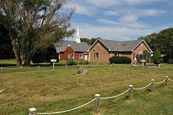
In 1970, a new church, the Church of the Resurrection, was built next to the old church's foundation. This church has helped protect the old ruins and keep historical records about Joppa. The Rumsey Mansion was also bought and restored in the 1960s. It is now a private home.
Where is Joppatowne?
Joppatowne is located in the southwestern part of Harford County. To its west is the Gunpowder River, which forms the border with Baltimore County. Interstate 95 is to the north, and Maryland Route 152 is to the east. The Amtrak railroad line is to the south. U.S. Route 40 (Pulaski Highway) goes through the northern part of Joppatowne. This road leads to Aberdeen to the northeast and Baltimore to the southwest.
Joppatowne covers about 7.39 square miles (19.1 square kilometers) of land and water.
Joppatowne Today
| Historical population | |||
|---|---|---|---|
| Census | Pop. | %± | |
| 2020 | 13,425 | — | |
| U.S. Decennial Census | |||
As of 2020, Joppatowne had a population of 13,425 people. In 2000, there were 11,391 people living here. The community is home to Joppatowne High School, which is located near the center of the area.
See also
 In Spanish: Joppatowne (Maryland) para niños
 | James B. Knighten |
 | Azellia White |
 | Willa Brown |


