Joypurhat District facts for kids
Quick facts for kids
Joypurhat District
জয়পুরহাট
|
|
|---|---|

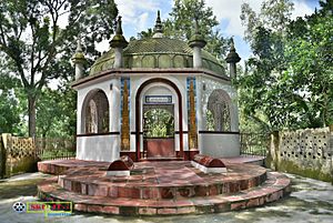
Shrine near Patharghata
|
|

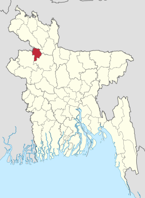
Location of Joypurhat in Bangladesh
|
|
| Country | |
| Division | Rajshahi Division |
| Established | February 26, 1984 |
| Area | |
| • Total | 965.4 km2 (372.7 sq mi) |
| Population
(2022 census)
|
|
| • Total | 956,430 |
| • Density | 990.71/km2 (2,565.92/sq mi) |
| Demonym(s) | Joypurhati, Rajshahiyo |
| Time zone | UTC+06:00 (BST) |
| Postal code |
5900
|
Joypurhat (Bengali: জয়পুরহাট) is a district located in the northern part of Bangladesh. It is part of the Rajshahi Division. This area is known for its rich history and important rivers.
Contents
History of Joypurhat
How Joypurhat Got Its Name
For a long time, Joypurhat was ruled by the Pala Empire and later the Sena dynasty. Not much was known about its history until the 16th and 17th centuries. The area was first called Baghabarihat. Later, it was also known as Gopendraganjahat.
A police station, called Lalbazar Thana, was set up. It covered the areas of what are now Joypurhat Sadar Upazila and Panchbibi Upazila. This police station was located near the Small Jamuna River. Lalbazar Thana was a busy town back then. People used the Small Jamuna River for travel and trade.
Over time, the area's borders changed. In 1821, a new district called Bogra District was formed. It included parts of Dinajpur, Rangpur District, and Rajshahi District. Lalbazar Thana, Khetlal Upazila, and Badalgachhi Upazila became part of Bogra.
In 1884, a railway line was built from Kolkata District to Jalpaiguri District. Eight railway stations were built in what is now Joypurhat District. The station in this area was first called Baghabari railway station.
People started moving closer to the railway line. The areas near the river became less important. The name 'Baghabari railway station' was changed to Joypurhat railway station. From then on, the whole area became known as Joypurhat. Some people believe Joypurhat was named after King JoyPal of the Pala Empire, who once ruled here.
Geography of Joypurhat
Rivers Flowing Through Joypurhat
Joypurhat District has five main rivers:
- The Small Jamuna River flows through Joypurhat Sadar Upazila and Panchbibi Upazila.
- The Tulshiganga River passes through Joypurhat Sadar Upazila, Khetlal Upazila, and Akkelpur Upazila.
- The Chiri River flows through Panchbibi Upazila.
- The Haraboti River passes through Panchbibi Upazila.
- The Sree River flows through Chakbarkat in Joypurhat Sadar Upazila.
Climate in Joypurhat
Joypurhat has a Tropical climate. This means it gets a lot of rain, especially in summer. According to the Köppen climate classification system, the average yearly temperature is about 25.4°C. The average yearly rainfall is 1738 mm.
The driest month is December, with only about 3 mm of rain. The wettest month is July, with an average of 364 mm of rain. August is the warmest month, with an average temperature of 28.9°C. January is the coolest month, with an average temperature of 18°C.
| Climate data for Joypurhat | |||||||||||||
|---|---|---|---|---|---|---|---|---|---|---|---|---|---|
| Month | Jan | Feb | Mar | Apr | May | Jun | Jul | Aug | Sep | Oct | Nov | Dec | Year |
| Mean daily maximum °C (°F) | 24.8 (76.6) |
27.6 (81.7) |
32.5 (90.5) |
35 (95) |
33.6 (92.5) |
32.4 (90.3) |
35.5 (95.9) |
35.3 (95.5) |
31.2 (88.2) |
29.5 (85.1) |
28.7 (83.7) |
25.9 (78.6) |
31.0 (87.8) |
| Daily mean °C (°F) | 18 (64) |
20.2 (68.4) |
24.9 (76.8) |
28.4 (83.1) |
28.7 (83.7) |
28.9 (84.0) |
28.9 (84.0) |
28.9 (84.0) |
28.6 (83.5) |
27 (81) |
22.8 (73.0) |
19.3 (66.7) |
25.4 (77.7) |
| Mean daily minimum °C (°F) | 11.2 (52.2) |
12.9 (55.2) |
17.3 (63.1) |
21.9 (71.4) |
23.8 (74.8) |
25.4 (77.7) |
26.1 (79.0) |
26.2 (79.2) |
25.6 (78.1) |
22.9 (73.2) |
17 (63) |
12.6 (54.7) |
20.2 (68.5) |
| Average precipitation mm (inches) | 10 (0.4) |
15 (0.6) |
21 (0.8) |
52 (2.0) |
186 (7.3) |
330 (13.0) |
364 (14.3) |
321 (12.6) |
283 (11.1) |
140 (5.5) |
13 (0.5) |
3 (0.1) |
1,738 (68.2) |
| Source: National newspapers | |||||||||||||
The amount of rainfall changes a lot between the driest and wettest months. The average temperatures also vary by about 10.9°C throughout the year.
People of Joypurhat
Population and Literacy
| Historical population | ||
|---|---|---|
| Year | Pop. | ±% p.a. |
| 1974 | 507,741 | — |
| 1981 | 619,351 | +2.88% |
| 1991 | 765,011 | +2.13% |
| 2001 | 846,696 | +1.02% |
| 2011 | 913,768 | +0.77% |
| 2022 | 956,430 | +0.42% |
| Sources: | ||
According to the 2022 Census of Bangladesh, Joypurhat District has 956,430 people. About 23.4% of them live in cities. There are 269,904 households in the district. The population density is about 945 people per square kilometer. The literacy rate (people aged 7 and over who can read and write) is 73.6%. This is very close to the national average for Bangladesh, which is 74.7%.
Religions in Joypurhat
Most people in Joypurhat District are Muslim, making up 89.66% of the population. Hindus are the second largest group at 8.83%. Christians make up 0.53% of the population. Other religions, mainly Sarna, account for 0.97%.
| Religions in Joypurhat district (2011) | ||||
|---|---|---|---|---|
| Religion | Percent | |||
| Muslims | 89.66% | |||
| Hindus | 8.83% | |||
| Tribal religion | 0.97% | |||
| Christians | 0.53% | |||
| Other or not stated | 0.01% | |||
| Religion | Population (1941) | Percentage (1941) | Population (2011) | Percentage (2011) |
|---|---|---|---|---|
| Islam |
165,275 | 73.46% | 819,235 | 89.66% |
| Hinduism |
47,664 | 21.18% | 80,696 | 8.83% |
| Tribal religion |
11,929 | 5.30% | 8,888 | 0.97% |
| Christianity |
130 | 0.06% | 4,822 | 0.53% |
| Others | 2 | 0.00% | 127 | 0.01% |
| Total Population | 225,000 | 100 | 913,768 | 100% |
There are also ethnic minority groups, like the Santals, who make up about 2.53% of the population.
Economy of Joypurhat
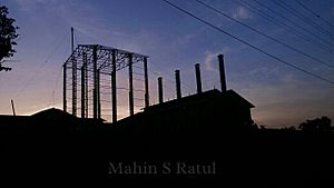
Joypurhat's economy mostly depends on farming. Farmers grow seasonal crops like rice, potatoes, wheat, onions, mangoes, jackfruits, and bananas. The district also grows a lot of sugarcane. It is home to Joypurhat Sugar Mill's Limited, which is the largest sugar mill in Bangladesh.
Besides farming, Joypurhat has many industries, rice mills, and poultry farms. It exports many farm products to other places. The Hili land port is very close to Joypurhat. This means many people from the district work in import and export businesses through this port. Most of the vehicles from this port travel through Joypurhat. This makes the district a good place for many types of businesses.
Arts and Culture
Joypurhat has a rich folk culture, which means it has many traditional songs, dances, and stories. In the past, during the British Raj period, many festivals were held. These included performances like keerton, jaree, palagaan, kabigaan, baul, murshidee, lokgeeti, bhaoyaiya, and jattra.
After the Bangladesh Liberation War in 1971, many cultural groups were formed in the district and its sub-districts. One of these groups is the Drama Circle.
Places to Visit
Jamalganj is a town about 10 km southwest of Joypurhat. Near Jamalganj, about 6 km northwest, is Pahar Pur (Buddhist Bihar), also known as Sompur Bihar. This is a very old and important place that shows the history of philosophy, architecture, art, and sculptures in the region. It is recognized by UNESCO (United Nations Educational, Scientific and Cultural Organization) as a World Heritage Site.
Jamalganj is also known for its traditional market, which serves the surrounding areas. It is famous for its farm products like bananas, paddy (rice), wheat, and potatoes. Jamalganj is also known for its coal and cement.
How Joypurhat is Governed
Sub-districts (Upazilas)
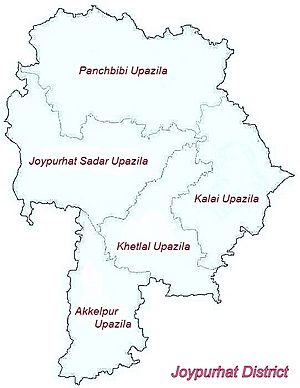
Joypurhat District is divided into five smaller areas called sub-districts or upazilas:
| upazila | area (km2) | population |
|---|---|---|
| Joypurhat | 238.5 | 256,691 |
| Akkelpur | 139.47 | 128,952 |
| Kalai | 166.30 | 129,329 |
| Khetlal | 142.60 | 115,871 |
| Panchbibi | 278.53 | 240,979 |
Municipalities
Joypurhat District has five municipalities. The current Deputy Commissioner (DC) is Mohammad Yasin, and the Mayor is MD Mustafizur Rahaman Mostak.
Parliamentary Seats
Joypurhat has two seats in the national parliament: Joypurhat-1 and Joypurhat-2. These seats are represented by elected members of parliament (MPs).
| Constituency NO. |
Constituency Name |
Extent | Present Jatiyo Sangshad MP | Political party | Legislature | Election occupied |
|---|---|---|---|---|---|---|
|
|
Joypurhat-1 |
|
|
Bangladesh Awami League | 11th Parliament | December 30, 2018 |
|
|
Joypurhat-2 |
|
|
Bangladesh Awami League | 11th Parliament | December 30, 2018 |
Transportation
Roads in Joypurhat
Joypurhat has a total of 342.59 km of paved roads, 61.59 km of semi-paved roads, and 1569 km of unpaved roads.
Railway Stations
There are eight railway stations in Joypurhat District, with a total of 38.86 km of railway lines.
- Joypurhat railway station, in Joypurhat Sadar Upazila
- Panchbibi railway station, in Panchbibi Upazila
- Jamalganj railway station, in Akkelpur Upazila
- Akkelpur railway station, in Akkelpur Upazila
- Jafarpur railway station, in Akkelpur Upazila
- Tilakpur railway station, in Akkelpur Upazila
- Bagjana railway station, in Panchbibi Upazila
The Joypurhat railway station was built in 1884 during the British Raj period. It is a very important railway station in northern Bangladesh.
Education in Joypurhat
Joypurhat District has 27 colleges. Some of the well-known ones include Joypurhat Government College, Akkelpur Mujibar Rahman College, and Joypurhat Government Women's College (started in 1972).
Joypurhat Girls' Cadet College, founded in 2006, is a special military high school and college just for girls.
Some notable secondary schools in the district are R.B. Govt. High School (1946), Haripur High School (1917), and Khanjanpur High School (1901).
Religion in Joypurhat
Joypurhat District has many places of worship. There are 2573 mosques, which are Muslim places of worship. Many of these mosques also have libraries. There are 424 temples for Hindus, 21 churches for Christians, and 18 Buddhist temples. One famous mosque is the Hinda - Kasba Shahi Mosque.
Famous People from Joypurhat
| Name | Birthplace | Notable works | Time period |
|---|---|---|---|
| Poet Jayadeva Goswami | Kendoil village, Joypurhat Sadar Upazila | Geeti Gabinda Grontho (গীতি গবিন্দ গ্রন্থ) | In the time period of King Lakshman Sen |
See also
 In Spanish: Jaipurhat (zila) para niños
 | Sharif Bey |
 | Hale Woodruff |
 | Richmond Barthé |
 | Purvis Young |


