
Kagawa Prefecture facts for kids
Quick facts for kids Kagawa Prefecture |
|||||||||
|
|||||||||
 |
|||||||||
| Capital | Takamatsu | ||||||||
| Region | Shikoku | ||||||||
| Island | Shikoku | ||||||||
| Governor | Keizo Hamada | ||||||||
| Area (rank) | 1,861.70 km² (47th) | ||||||||
| - % water | 2.8% | ||||||||
| Population (December 1, 2010) | |||||||||
| - Population | 995,465 (40th) | ||||||||
| - Density | 534.71 /km² | ||||||||
| Districts | 5 | ||||||||
| Municipalities | 17 | ||||||||
| ISO 3166-2 | JP-37 | ||||||||
| Website | www.pref.kagawa.jp | ||||||||
| Prefectural Symbols | |||||||||
| - Flower | Olive (Olea europaea) | ||||||||
| - Tree | Olive (Olea europaea) | ||||||||
| - Bird | Oriental cuckoo (Cuculus poliocephalus) | ||||||||
| - Fish | |||||||||
 Symbol of Kagawa Prefecture |
|||||||||

Kagawa Prefecture (香川県, Kagawa-ken) is a special area in Japan. It is located in the Shikoku region, on the island of Shikoku. The main city, or capital, of Kagawa is Takamatsu.
Contents
History of Kagawa
Kagawa was once known by a different name: Sanuki Province. This was a long time ago, before Japan was divided into prefectures like it is today.
Throughout history, Kagawa has often faced droughts. A drought is when there is not enough rain for a very long time. For example, in 1973, the region was even called "the Takamatsu desert" because it was so dry!
Geography of Kagawa
Kagawa Prefecture is found in the northwest part of the Shikoku island. It shares its borders with Ehime Prefecture to the southwest. To the south, it touches Tokushima Prefecture.
Kagawa has a beautiful coastline along the Seto Inland Sea. This sea has many small islands. Across the sea, you can see Okayama Prefecture.
To help with the droughts, many dams were built in Kagawa. Between 1947 and 1974, 17 dams were constructed to store water.
Cities in Kagawa
Kagawa Prefecture has several important cities:
|
|
Towns in Kagawa
Here are the towns and villages located in different districts within Kagawa:
|
|
|
National Parks in Kagawa
About 11% of Kagawa's total land area is protected as National Parks. These parks help keep nature safe and beautiful for everyone to enjoy.
Shrines and Temples
Tamura jinja is a very important Shinto shrine in Kagawa. It is known as the chief shrine (or ichinomiya) for the prefecture. Shinto shrines are places of worship in Japan's traditional Shinto religion.
Related pages
Images for kids
-
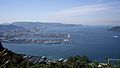
A view of Takamatsu, the capital city.
-
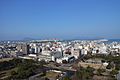
A beautiful view from Marugame Castle.
-
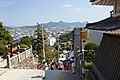
The path leading to Kotohira-gu shrine.
-
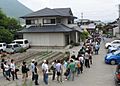
People waiting in line for delicious udon noodles in Kagawa.
-
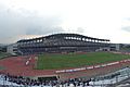
Pikara Stadium in Marugame, a place for sports and events.
-
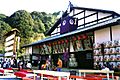
The Kanamaruza Kabuki Theatre, a historic place for traditional Japanese plays.
-
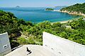
Benesse House, a museum on Naoshima island.
-
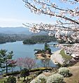
The calm waters of Manno Lake.
-
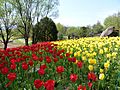
A colorful tulip garden in Sanuki Manno National Park.
-
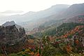
The stunning Kankakei gorge on Shodoshima island.


See also
 In Spanish: Prefectura de Kagawa para niños
