
Kalawao County, Hawaii facts for kids
Quick facts for kids
Kalawao County
|
|
|---|---|

Kalaupapa peninsula
|
|

Location within the U.S. state of Hawaii
|
|
 Hawaii's location within the U.S. |
|
| Country | |
| State | |
| Founded | 1905 |
| Named for | Kalawao |
| Seat | none (administered by Hawaii Dept. of Health) |
| Largest community | Kalaupapa |
| Area | |
| • Total | 53 sq mi (140 km2) |
| • Land | 12 sq mi (30 km2) |
| • Water | 41 sq mi (110 km2) 77.3% |
| Population
(2020)
|
|
| • Total | 82 |
| • Density | 1.547/sq mi (0.597/km2) |
| Time zone | UTC−10 (Hawaii–Aleutian) |
| • Summer (DST) | HADT |
| Congressional district | 2nd |
Kalawao County (Hawaiian: Kalana o Kalawao) is a special county in the U.S. state of Hawaii. It is the smallest county in the United States by land area. It is also the second-smallest county by population.
This unique county covers the Kalaupapa Peninsula on the island of Molokaʻi. High cliffs, over a quarter-mile tall, separate the peninsula from the rest of Molokaʻi. The only land path is a mule trail.
Because it has a very small population (only 82 people in 2020), Kalawao County works differently from other counties in Hawaii. It acts as a judicial district of Maui County. Maui County includes the rest of Molokaʻi. Kalawao County does not have its own elected government.
From 1866 to 1969, this area was used as a special settlement. People with Hansen's disease (also known as leprosy) were sent here for treatment and care.
Contents
History of Kalawao County
For over 100 years, from 1866 to 1969, people with Hansen's disease were sent to the Kalaupapa peninsula. This was a policy of isolation, or quarantine, used by the Hawaiian Kingdom and later governments. The goal was to prevent the disease from spreading.
This policy ended when new antibiotic medicines were found. These medicines could treat Hansen's disease effectively. Patients could then be treated at home and were no longer contagious.
Many people who lived on the peninsula chose to stay there. The state of Hawaii promised they could live there for the rest of their lives. Today, the population includes these former patients, along with state employees and park staff.
Visitors aged 16 and older can visit the county. They need special permission from the government or must join an official tour. In 1980, the Kalaupapa National Historical Park was created. Its purpose is to protect the county's history and natural environment.
Geography and Land Area
Kalawao County is very small. The U.S. Census Bureau says its total area is 53 square miles. Only 12 square miles of this is land. The other 41 square miles (77.3%) is water.
It is the smallest true county in the United States by land area. Some independent cities in Virginia are smaller. However, these are often considered "county equivalents" for statistics.
Kalaupapa Peninsula Formation
The Kalaupapa Peninsula is where the county's only community, Kalaupapa, is located. This peninsula was formed by lava. The lava erupted from the ocean floor near Kauhakō Crater. It spread out to create a low, flat shield volcano. This was the most recent volcanic activity on Molokaʻi. It happened after the tall cliffs were formed by erosion.
County Subdivisions: Ahupuaʻa
Kalawao County is divided into four traditional Hawaiian land sections called ahupuaʻa. These run from west to east.
| Ahupuaʻa | Area mi2 |
Population | Description |
|---|---|---|---|
| Kalaupapa | 2.079 | 65 | This is the western part of the Kalaupapa peninsula. |
| Makanalua | 3.229 | 8 | This strip of land is in the center of the peninsula. It includes Kalaupapa Airport. |
| Kalawao | 3.294 | 9 | This covers the eastern coast of Kalaupapa peninsula. |
| Waikolu | 5.544 | 0 | This area includes a valley and has no residents. |
| Kalawao County | 14.146 | 82 |
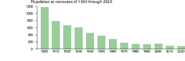
Population Changes Over Time
| Historical population | |||
|---|---|---|---|
| Census | Pop. | %± | |
| 1900 | 1,177 | — | |
| 1910 | 785 | −33.3% | |
| 1920 | 667 | −15.0% | |
| 1930 | 605 | −9.3% | |
| 1940 | 446 | −26.3% | |
| 1950 | 340 | −23.8% | |
| 1960 | 279 | −17.9% | |
| 1970 | 172 | −38.4% | |
| 1980 | 144 | −16.3% | |
| 1990 | 130 | −9.7% | |
| 2000 | 147 | 13.1% | |
| 2010 | 90 | −38.8% | |
| 2020 | 82 | −8.9% | |
| 2023 (est.) | 81 | −10.0% | |
| U.S. Decennial Census 1790-1960 1900–1990 1990–2000 2010–2018 |
|||
In 2000, there were 147 people living in Kalawao County. By 2010, the population had dropped to 90. In 2020, it was 82 people. The population density was about 11 people per square mile.
The racial makeup in 2000 was mostly Pacific Islander (48%). Other groups included White (26%) and Asian (17%). Kalawao County has the highest percentage of Pacific Islanders of any U.S. county.
Most households (79%) were made up of single individuals. About 31% of households had someone aged 65 or older living alone. The average age of residents was 59 years old.
The population has steadily decreased since 1900, as shown in the chart below:
Today, the residents include 16 former patients. There are also 40 federal employees who work on preservation projects. Some state-employed health workers live there too.
Transportation to Kalawao County
Getting to Kalawao County is not easy. You can arrive by air at Kalaupapa Airport. This airport has flights to Molokaʻi Airport and to Honolulu Airport.
The only other way to reach the county is by a very steep mule trail. This trail drops 1,600 feet from the rest of Molokaʻi. Large items and supplies are delivered to the county once a year by a special boat called a barge, usually in July.
Education in Kalawao County
Kalawao County is part of the Hawaii Department of Education school district.
See also
 In Spanish: Condado de Kalawao para niños
