Kameoka, Kyoto facts for kids
Quick facts for kids
Kameoka
亀岡市
|
|||||||||||
|---|---|---|---|---|---|---|---|---|---|---|---|

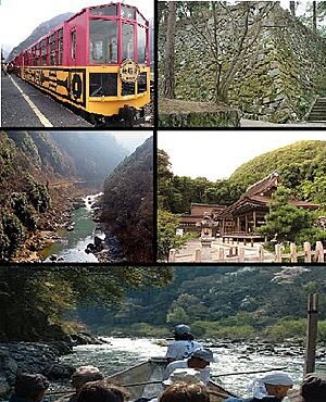
Top left: A sightseeing train at Sagano Sightseeing Line, Top right: Kameoka Castle site, Middle left: Hozu Valley, Middle right: Kameoka Izumo Shrine, Bottom: A sightseeing boat at Hozu Valley
|
|||||||||||
|
|||||||||||

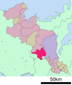
Location of Kameoka in Kyoto Prefecture
|
|||||||||||
| Country | Japan | ||||||||||
| Region | Kansai | ||||||||||
| Prefecture | Kyoto | ||||||||||
| Area | |||||||||||
| • Total | 224.80 km2 (86.80 sq mi) | ||||||||||
| Population
(January 1, 2022)
|
|||||||||||
| • Total | 87,518 | ||||||||||
| • Density | 389.315/km2 (1,008.321/sq mi) | ||||||||||
| Time zone | UTC+09:00 (JST) | ||||||||||
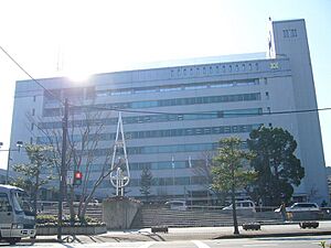
| City hall address | 8 Yasumachi Nonogami, Kameoka-shi, Kyōto-fu 621-8501 | ||||||||||
|
|||||||||||
Kameoka (亀岡市 (Kameoka-shi)) is a city located in Kyoto Prefecture, Japan. As of January 1, 2022, about 87,518 people lived in Kameoka. The city covers an area of 224.80 square kilometers (about 86.8 square miles).
Contents
Exploring Kameoka's Geography
Kameoka is located west of Kyoto and north of Osaka. It sits on the border between two old Japanese provinces, Tanba and Yamashiro. This area is sometimes called Southern Tanba.
For many years, Kameoka was an important travel spot. It connected the San'in region and Tanba province with Kyoto. Today, it is a suburb of the larger Kyoto area.
One famous activity here is the Hozugawa Kudari. This is a fun boat ride down the Hozu River. Kameoka is also home to Anaoji Temple. This temple is one of 21 temples in western Japan where you can get special good luck charms.
Cities and Towns Nearby
Kameoka shares its borders with several other places:
Kameoka's Climate
Kameoka has a Humid subtropical climate. This means it has warm summers and cool winters. There is usually light or no snowfall.
The average yearly temperature in Kameoka is about 13.5 degrees Celsius (56.3°F). The city gets about 1690 mm (66.5 inches) of rain each year. September is usually the wettest month. Temperatures are highest in August, around 25.4 degrees Celsius (77.7°F). January is the coldest month, with temperatures around 2.1 degrees Celsius (35.8°F).
Population Changes in Kameoka
The number of people living in Kameoka grew steadily until around the year 2000. Since then, the population has gone down a little bit.
| Historical population | ||
|---|---|---|
| Year | Pop. | ±% |
| 1960 | 42,355 | — |
| 1970 | 47,151 | +11.3% |
| 1980 | 69,410 | +47.2% |
| 1990 | 85,283 | +22.9% |
| 2000 | 94,555 | +10.9% |
| 2010 | 92,416 | −2.3% |
| 2020 | 86,174 | −6.8% |
A Look at Kameoka's History
Kameoka was once part of an ancient area called Tanba Province. Farming, especially growing rice, started here during the Yayoi period (around 300 BC to 300 AD). You can still see many large kofun (ancient burial mounds) from that time.
In the 6th century, the area was important during a power struggle. A king named Yahiko was defeated by Emperor Keitai. Kameoka was also home to important religious sites. These included the main shrine of the province, Izumo-daijingū, and the Tanba Kokubun-ji temple.
The area around Kameoka grew because it was a key entry point to Kyoto. In 1333, a powerful leader named Takauji Ashikaga gathered his army in Kameoka. He did this to help end a conflict called the Genkō Rebellion in Kyoto.
During the Sengoku period (a time of civil war), a warlord named Akechi Mitsuhide built Kameyama Castle here. He also planned the castle town around it. This town became the center of modern Kameoka.
Later, during the Edo period, Kameoka was the main city of the Tanba-Kameyama Domain. This area was ruled by different powerful families called fudai daimyo.
In 1869, Kameyama was renamed Kameoka. This was to avoid confusion with another city named Kameyama in Mie Prefecture. The modern town of Kameyama was officially created on April 1, 1889. On January 1, 1955, Kameoka merged with 15 nearby villages. At that time, it officially became a city.
Kameoka's Economy
For a long time, Kameoka was a farming area that supplied food to Kyoto. Kyoto was Japan's old capital city. Farmers in Kameoka grew many ingredients for traditional Japanese food. These included chestnuts, black beans, azuki beans, rice, matsutake mushrooms, yams, and daikon radishes.
They also provided beef, chicken, and ayu (also known as sweetfish). Today, Kameoka is a mix of farming and light manufacturing. More and more, it is also a place where people live and travel to Kyoto for work.
Education in Kameoka
Kameoka has one university:
- Kyoto Gakuen University
Schools for Younger Students
The city government runs 17 public elementary schools and seven public middle schools. The Kyoto Prefectural Department of Education operates two public high schools in Kameoka.
Getting Around Kameoka
Railway Lines
![]() JR West operates the San'in Main Line, also known as the Sagano Line, through Kameoka.
JR West operates the San'in Main Line, also known as the Sagano Line, through Kameoka.
- Hozukyō - Umahori - Kameoka - Namikawa - Chiyokawa
Major Highways
Several important roads pass through Kameoka:
 Kyoto Jūkan Expressway
 National Route 9
 National Route 372
 National Route 423
 National Route 477
 National Route 478
Kameoka's Sister Cities
Kameoka has special friendship agreements with cities around the world:
- Knittelfeld, Austria - since April 14, 1964
- Stillwater, Oklahoma, US - since November 3, 1985
- Jandira, Brazil - since November 3, 1980
- Suzhou, China - since December 31, 1996
Places to Visit in Kameoka
- Kameyama Castle ruins - the remains of the old castle
- Izumo-daijingū Shinto shrine - an important religious site
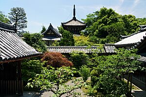
- Anao-ji temple - part of a famous pilgrimage route
- Tanba Kokubun-ji ruins - an ancient temple site
- Chitose Kurumazuka Kofun - an ancient burial mound
Sports in Kameoka
- Kyoto Stadium – This is the home stadium for Kyoto Sanga FC. They are a professional football (soccer) club.
Famous People from Kameoka
- Maruyama Ōkyo
- Aya Domenig
See also
 In Spanish: Kameoka (Kioto) para niños
 | Emma Amos |
 | Edward Mitchell Bannister |
 | Larry D. Alexander |
 | Ernie Barnes |


