Kankakee Torrent facts for kids

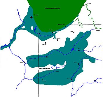
The Kankakee Torrent was a huge, sudden flood that happened around 19,000 years ago in the Midwestern United States. This massive flood started when a natural ice and dirt dam broke. This dam was holding back a large glacial lake called Lake Chicago. This lake was fed by melting ice from the Laurentide Ice Sheet during the Late Wisconsin Ice Age.
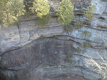
Today, you can still see the effects of this ancient flood. Places like Kankakee River State Park and Starved Rock State Park along the Illinois River show how powerful the Kankakee Torrent was.
How the Flood Changed the Land
The Kankakee Torrent dramatically changed the valleys of the Kankakee River and Illinois River. These rivers mostly follow the paths carved by the flood, which scientists believe happened in just a few days!
One famous example is Starved Rock State Park in north-central Illinois. Most of Illinois is flat, but Starved Rock has many deep canyons. These canyons were carved out by the powerful waters of the Kankakee Torrent.
Another interesting feature left by the flood is "sand prairies." These areas formed where the floodwaters slowed down and dropped huge amounts of sand. When early European settlers arrived, they even found sand dunes in some of these places.
The Kankakee River itself shows many signs of this ancient flood. Kankakee River State Park is a great place to see these features. For example, many smaller streams flow into the Kankakee River over waterfalls. This happens because the flood carved the Kankakee River valley much deeper than normal river erosion would. The smaller streams haven't had enough time to cut down to the same level. This effect is very clear where Rock Creek joins the Kankakee.
The Kankakee Torrent also affected the Ohio River and Mississippi River. It pushed the Ohio River further south and the Mississippi River further west.
How the Flood Happened
The land in this area is made of dolomite bedrock. Before the glaciers, the bedrock surface was uneven. This meant the layer of glacial dirt and rocks varied in depth. Some spots had bedrock close to the surface, while others had it as deep as 100 feet (30 meters).
The floodwaters came from the melting "Valparaiso glacier." This glacier was part of the huge Laurentide Ice Sheet. Meltwater came from three different parts of this ice sheet:
- The Michigan lobe in the Michigan basin.
- The Huron-Erie lobe to the east, in the Maumee valley in Ohio.
- The Sturgis Lobe from Michigan, flowing across northeast Indiana.
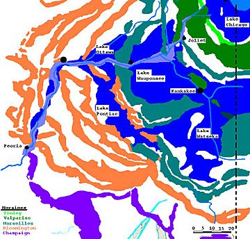
This meltwater built up behind a natural ridge called the Marseilles moraine, forming several large ancient lakes. These included Lake Wauponsee in the Morris Basin, which stretched into Indiana. Water from Lake Wauponsee flowed south through the Iroquois River into Lake Watseka. The water was then blocked by another ridge, the Farm Ridge moraine, near LaSalle, Illinois. This blockage created Lake Ottawa and Lake Pontiac.
The Flood Events
The Kankakee Torrent wasn't just one single flood. It was a series of floods that happened over possibly hundreds of years. At first, the floods were likely small. But over time, they grew larger and larger. They reached their peak before the Valparaiso glacier finally melted away.
Before these floods, the Kankakee River valley near the city of Kankakee, Illinois, was not very deep or wide. It was a flat plain with a small river. The early floodwaters spread out across this plain. When the flood was at its highest, the water found new paths and flowed across ridges to the west.
As the floods continued, they wore away much of the plain and even started cutting into the bedrock beneath. In the final stages, deep channels were carved into the solid rock.
Along the south bank of the Kankakee River, west of Kankakee, Illinois, you can see long, narrow ridges. These are gravel bars left by the Kankakee flood. The strong flow of water scoured the bedrock and moved large rocks, including glacial erratics (boulders carried by glaciers). The fastest flow in the center created a main channel, which the modern river still follows. The floodwaters were guided by channels between the moraines, moving west and then south. When the flood reached the LaSalle, Illinois, area, it joined the ancient Mississippi River valley. This area is now known as the Big Bend of the Illinois River.
Flood Deposits
The melting glacier left behind a lot of material, called outwash, which was carried beyond the Kankakee area. The heavier, coarser outwash, like large rocks and rubble, formed bars along the river. As the flood slowed down, lighter sands and silts were left behind on the valley floor.
Later, the wind picked up this sand, creating sand dunes to the south and southeast. You can find these sand deposits as far south as Sand Ridge State Forest in central Illinois.
|
 | Dorothy Vaughan |
 | Charles Henry Turner |
 | Hildrus Poindexter |
 | Henry Cecil McBay |


