Little Sandy Desert facts for kids
Quick facts for kids Little Sandy Desert |
|
---|---|
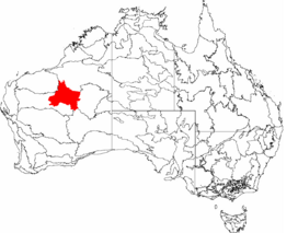
![]() The IBRA regions, with Little Sandy Desert in red
|
|
Area | 111,500 km2 (43,100 sq mi) |
Geography | |
State | Western Australia |
Region | Australia |
The Little Sandy Desert, often called the LSD for short, is a large desert area located in the state of Western Australia. It's known for its red sand dunes, rocky plains, and unique plants and animals adapted to a dry environment. It's part of a much larger area called the Western Desert cultural region and is officially recognised as a specific type of natural area called an interim Australian bioregion.
Contents
Where Does It Fit In?
The Little Sandy Desert is like a piece in a giant desert puzzle. It sits right next to two even bigger deserts:
- The Great Sandy Desert: To the north, covering about 267,250 square kilometres (that's about 103,190 square miles!).
- The Gibson Desert: To the east, covering about 156,300 square kilometres (about 60,300 square miles!).
All three of these deserts are part of the enormous Australian Arid Zone, which is a huge dry area covering the middle of the Australian continent. The Little Sandy Desert itself covers a large area of about 110,900 square kilometres (around 42,800 square miles).
The nearest large natural area to the north is the Karlamilyi National Park, which is another important protected place.
History
People have lived in and cared for the land of the Little Sandy Desert for thousands of years.
The original people who have a deep connection to this land are Aboriginal Australian groups. Historically, the Mandilara people were identified with the region. Today, the group officially recognised as the traditional owners of much of this land are the Martu people. They have lived here for a very, very long time and have a deep understanding of the desert, its plants, animals, and water sources.
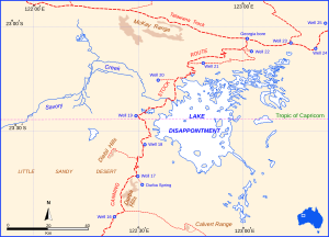
In the early 1900s, a long and difficult route was created through this desert and others. It was called the Canning Stock Route, and it was used to move cattle across the country. Travelling this route was incredibly challenging due to the harsh conditions.
Geography
The Little Sandy Desert shares many features with its neighbours, the Great Sandy Desert and the Gibson Desert.
The landscape is mostly made up of:
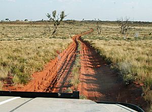
- Red Sand Dunes: Long, wavy hills of sand, often reddish in colour.
- Sandstone Mesas: Flat-topped hills or mountains with steep sides, made of sandstone rock.
- Rocky Plains: Flat areas covered in rocks and stones.
Climate
Deserts are known for being dry, and the Little Sandy Desert is no exception! It gets very little rain, and the amount changes a lot from year to year. On average, it receives only about 250–350 millimetres (about 9.8–13.8 inches) of rain each year. Most of this rain falls during the summer months. Looking at data from 1890 to 2005, the middle amount of rain the whole desert gets in a year is even lower, around 178 millimetres (about 7.0 inches). It can get extremely hot, especially in the summer. Finding water in the desert is crucial for survival.
Water
The Rudall River starts in the Little Sandy Desert and flows towards the northeast into the Great Sandy Desert. It doesn't always flow with water; sometimes it only reaches a temporary salt lake called Lake Dora.
There are a few places in the rocky hills where water stays all the time. There are also some waterholes along the old Canning Stock Route that were important stops for travellers.
Communities
There are a few small towns and communities located near or within the desert. Jigalong is a town on the western edge of the desert. In 2016, it had about 300 people living there. The Martu people are the traditional owners of this area. Parnngurr and Punmu are two other smaller communities in the region.
Life in the Desert
Even though it's a dry place, the Little Sandy Desert is full of life! It has a high level of biodiversity, meaning there are many different kinds of plants and animals. However, some of these species are facing challenges.
Plants
The most common type of plant cover is called hummock grasslands, made up of tough grasses like Triodia. You can also find different types of trees and shrubs, like eucalypts, acacias, grevilleas, and bloodwood trees, especially on the sand hills. As of 2020, scientists had found over 2000 different types of plants in the desert! Only two of these were considered threatened species at that time. The Martu people have traditionally used many of these plants for food, medicine, and making tools. For example, the bark of the birdflower plant is used to make belts and sandals, and the spear tree is used for making spears and digging sticks.
Animals
The desert is home to many reptiles and birds. However, sadly, many small- to medium-sized mammals that used to live here have disappeared, and many others are now threatened.
Over 116 different bird species have been seen in the whole desert area. This includes birds like the Australian bustard and the bush stone-curlew.
Some of the animals that are currently threatened in the Little Sandy Desert include:
- Greater bilby (a cute, rabbit-like marsupial)
- Princess parrot (a beautiful, colourful bird)
- Kakarratul/northern marsupial mole (a small, blind marsupial that lives underground)
- Australian bustard (a large ground-dwelling bird)
- Brush-tailed mulgara (a small, carnivorous marsupial)
- Grey falcon (a rare bird of prey)
Threats
The plants and animals in the Little Sandy Desert face several dangers:
- Wildfires: Fires can spread quickly in the dry environment and harm plants and animals.
- Feral Animals: Animals that are not native to Australia, like camels, donkeys, horses, rabbits, cats, and foxes, cause big problems. Feral camels can damage water sources.
Camels, donkeys, horses, and rabbits eat too much vegetation, harming the ecosystem. Feral cats hunt and kill native animals like bilbies and mulgara. Foxes are a major threat to many native mammals.
- Weeds: Plants that are not native can take over and push out the native plants. Buffel grass is a big problem because it's tough and makes fires burn hotter, which is made worse by climate change.
- Uncontrolled Grazing: Too many animals (both native and feral, and sometimes livestock) eating plants in one area can damage the land.
Protecting the Desert: Conservation Efforts
Efforts are being made to protect the special environment of the Little Sandy Desert.
Protected Areas
About 4.6% of the Little Sandy Desert region is within a protected area. A large part of this is managed as an Indigenous Protected Area (IPA) called the Birriliburu IPA. This means the land is looked after by its traditional owners, the Martu people, who use their traditional knowledge combined with modern science to care for the country. The Birriliburu IPA also extends into the neighbouring Gibson Desert.
Organisations like Bush Heritage Australia help by doing surveys to count and study the plants and animals in areas like Katjarra.
The Australian government uses a system to divide the country into different natural regions based on things like climate, geology, landforms, plants, and animals. This helps with environmental planning. The Little Sandy Desert is recognised as an interim Australian bioregion, known as no. 63. This classification helps scientists and conservationists understand and manage the unique environment of the area.
Economy
The Little Sandy Desert is a remote and challenging place, so there aren't many big industries or lots of people living there.
Tourism
There are almost no facilities for tourists, and the environment is very harsh. It's only recommended for very experienced travellers who know how to survive in remote desert conditions without help. Many roads are not signposted. However, at a special place called Katjarra, there are a couple of basic camping spots with water tanks and toilets, and Indigenous rangers can guide visitors to parts that are open to the public.
Mining
The main economic activities in the area are mining for minerals like copper and gold. There is also some exploration happening to look for uranium.
Grazing
In some parts of the eastern desert, there is limited grazing of livestock animals.
Carnarvon Range
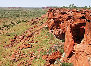
Within the Little Sandy Desert is a very important place called the Carnarvon Range, known as Katjarra to the Martu people.
Katjarra covers about 2,000 square kilometres (about 770 square miles) and is considered a sacred and very important place for Indigenous people. It is connected to important stories about creation beings, sometimes called the rainbow serpent.
It is home to a huge amount of ancient rock art and stone tools (artefacts). It's one of the largest rock art sites in Australia! The paintings, made using natural colours like ochre and charcoal, show animals like the bilby and the black-flanked rock-wallaby, as well as things like headdresses used in ceremonies. Over 25,000 stone artefacts have been found here.
Katjarra is fairly close to one of the wells on the Canning Stock Route and was visited by travellers. Access also increased from the 1970s due to nearby farming and mining activities. Sadly, over time, thousands of Aboriginal artefacts, like grinding stones, were lost or damaged. To protect this important place, the Australian government created a large Indigenous Protected Area in 2008, covering 66,540 square kilometres (about 25,690 square miles) of the Central Desert, including Katjarra. Management of this land was given back to the traditional owners. Katjarra was closed to the public for a while as part of the Birriliburu IPA so that plans could be made for future tourism and important archaeological and ecological research could be done.
One specific site within Katjarra is called Karnatukul. It was given the name "Serpent's Glen" in 1965 because of the many snake drawings found there, linked to Aboriginal stories about Rainbow Serpents.
Karnatukul is an incredibly important archaeological site. Until recently, it was thought that people had lived here continuously for up to 25,000 years, making it the oldest known site of continuous occupation in the Western Desert. However, a study published in September 2018 used new scientific methods and found that humans actually occupied the site much, much earlier – around 47,830 years ago! This discovery, and others like it requested by the native title holders, are changing how we understand the deep history of people living in dry areas and the concept of "deep time" – the vastness of geological and human history.
The 2018 study used a method called archaeobotany, which involves studying ancient plant remains. They found evidence that wattle plants were collected and used throughout the entire history of the site, from the very earliest times right up to more recent history. This confirms that people were continuously using the site for a very long time.
Wattle wood was incredibly useful! It was used for firewood, as a source of food, for bush medicine, and for making tools. Over 100 different species of wattle were used by Aboriginal peoples across Australia. Karnatukul shows one of the earliest known uses of firewood by humans.
The fact that people continued to live at Karnatukul through periods of extreme climate change, including when the desert became drier as ice sheets grew in other parts of the world, shows how adaptable and resilient the traditional owners were.
In 2014, the Birriliburu traditional owners and rangers decided to reopen Katjarra to the public for the month of July, hoping to do this each year in the future. Permits were needed, and there was a fee for visitors. This was also seen as an important opportunity for Aboriginal people, especially young people, to visit and reconnect with their culture and history at this significant place.
See also
In Spanish: Pequeño Desierto Arenoso para niños
- Deserts of Australia
- List of deserts by area