
Kathua facts for kids
Quick facts for kids
Kathua
|
|
|---|---|
|
City
|
|
    Clockwise from top: Atal Setu, Jasrota Fort, Industrial Estate
Atal Setu, Purthu Artificial Beach and Jasrota Fort in Kathua (J&K)
|
|

Kathua lies in the Jammu division (neon blue) of the Indian-administered Jammu and Kashmir (shaded in tan) in the disputed Kashmir region.
|
|
| Administering country | India |
| Union territory | Jammu and Kashmir |
| District | Kathua |
| Settled | 1025 BC |
| Named for | "KATHAI" |
| Government | |
| • Type | Municipal Council |
| • Body | Kathua Municipal Council (21) Seats |
| Area | |
| • Total | 28.32 km2 (10.93 sq mi) |
| Elevation | 393 m (1,289 ft) |
| Population
(2011)
|
|
| • Total | 59,866 |
| • Density | 3,765/km2 (9,750/sq mi) |
| Languages = Dogri & Hindi | |
| Time zone | UTC+5:30 (IST) |
| PIN |
184101(HEAD OFFICE), 184104(Mini Secretariat)
|
| Telephone code | 01922 |
| Literacy | 86.46% |
| Website | http://kathua.nic.in/ |
Kathua is a city and a special kind of town council in the Jammu division of India. It is part of Jammu and Kashmir, a beautiful area that is sometimes debated. The city is the main center of the Kathua district. It is divided into 27 smaller areas called wards, which make up the Kathua Municipal Council.
Kathua is located right next to NH-44, a big road in India. It is a busy place with many factories and an Indian Army base nearby. Because it is a major stopping point for goods and businesses, Kathua has many industries. These include textile factories, biotechnology and medicine research centers, cement factories, and many smaller businesses.
Contents
Geography of Kathua
Kathua is located at about 32.37 degrees North and 75.52 degrees East. It is about 393 meters (1,289 feet) above sea level. Three rivers surround the city. The Ravi River is about 7 kilometers (4.3 miles) away. The Ujjh River is about 11 kilometers (6.8 miles) further along the Jammu Highway.
Kathua itself sits along the banks of a khad, which is a small river or stream. Over the years, this stream has become quite polluted and is now used as a drain for sewage. The stream divides the city into two parts: Parliwand, meaning "the other side," and Orliwand, meaning "this side."
Even though Kathua is in a flat area, it is surrounded to the North by the snow-capped Sivalik Hills. The large Ranjit Sagar Lake is about 25 kilometers (15.5 miles) away. This lake helps to keep the climate cooler in Kathua. Kathua is located 88 kilometers (55 miles) south of Jammu.
People of Kathua
Population Details
The total population of Kathua city and its nearby areas is 59,688 people. This includes 31,717 males and 28,149 females. For every 1000 men, there are 888 women. There are 12,061 homes in the city and its surrounding areas.
Literacy Rates
In Kathua, 46,359 people can read and write, while 13,507 cannot. This means that about 86.46% of the people are literate. For males, the literacy rate is 90.7% (25,605 individuals). For females, it is 81.75% (20,754 individuals).
Languages Spoken
While Urdu is often used in official government papers, along with English, the main language spoken by people in Kathua is Dogri. Hindi is also widely spoken.
Religions in Kathua
Hinduism is the largest religion in Kathua. More than 91% of the people follow Hinduism. Sikhism is the second-largest religion, with about 4.75% of the people following it. Christianity makes up 1.09% of the population, and Islam makes up 2.68%.
Climate and Weather
Kathua has a climate that is affected by monsoons, with hot and humid summers. The city usually gets a lot of rain during the monsoon season. This is because it is on the side of the Sivalik Hills that faces the wind.
Because Kathua is close to rivers, its climate is moderate to very hot in summer. In winter, it can be mild to very cold. Summer temperatures can reach 37 degrees Celsius (98.6 degrees Fahrenheit). In winter, temperatures can drop below 0 degrees Celsius (32 degrees Fahrenheit) at night.
Heavy rain falls during the monsoon season in July and August. The city gets about 1700 millimeters (67 inches) of rain each year, mostly during monsoons and winters. Heavy hailstorms can happen in February and March, but they are very rare. Kathua does not get snowfall. Fog and sometimes Smog are common during the winters, especially in January and February.
Compared to Jammu, temperatures in Kathua are usually 3-4 degrees Celsius lower. December and January can be very cold, especially at night. February to April and October-November are pleasant and dry. August is generally humid and can be uncomfortable. Winters are also wet because of frequent rains. Late-night thunderstorms are common, and May is known for heavy dust storms.
| Climate data for Kathua (1983–2010) | |||||||||||||
|---|---|---|---|---|---|---|---|---|---|---|---|---|---|
| Month | Jan | Feb | Mar | Apr | May | Jun | Jul | Aug | Sep | Oct | Nov | Dec | Year |
| Record high °C (°F) | 26.6 (79.9) |
28.6 (83.5) |
33.6 (92.5) |
35.6 (96.1) |
37.8 (100.0) |
39.1 (102.4) |
38.9 (102.0) |
36.8 (98.2) |
34.5 (94.1) |
31.2 (88.2) |
31.0 (87.8) |
26.5 (79.7) |
39.1 (102.4) |
| Mean daily maximum °C (°F) | 18.1 (64.6) |
21.6 (70.9) |
26.5 (79.7) |
31.1 (88.0) |
34.1 (93.4) |
35.3 (95.5) |
32.1 (89.8) |
29.2 (84.6) |
26.8 (80.2) |
24.5 (76.1) |
20.5 (68.9) |
19.0 (66.2) |
26.5 (79.7) |
| Mean daily minimum °C (°F) | 2.5 (36.5) |
7.1 (44.8) |
13.0 (55.4) |
17.9 (64.2) |
22.6 (72.7) |
24.6 (76.3) |
24.1 (75.4) |
23.8 (74.8) |
22.1 (71.8) |
16.6 (61.9) |
11.3 (52.3) |
3.7 (38.7) |
15.8 (60.4) |
| Record low °C (°F) | −4.1 (24.6) |
0.2 (32.4) |
5.6 (42.1) |
9.2 (48.6) |
14.4 (57.9) |
17.6 (63.7) |
14.0 (57.2) |
14.0 (57.2) |
11.5 (52.7) |
7.4 (45.3) |
3.6 (38.5) |
−2.0 (28.4) |
−4.1 (24.6) |
| Average rainfall mm (inches) | 69.3 (2.73) |
73.2 (2.88) |
43.3 (1.70) |
35.4 (1.39) |
34.0 (1.34) |
114.7 (4.52) |
429.4 (16.91) |
725.9 (28.58) |
127.2 (5.01) |
26.9 (1.06) |
18.4 (0.72) |
81.0 (3.19) |
1,778.7 (70.03) |
| Average rainy days | 3.2 | 3.8 | 3.5 | 2.5 | 3.1 | 6.4 | 12.7 | 11.9 | 6.2 | 1.4 | 1.0 | 1.8 | 57.2 |
| Average relative humidity (%) | 86 | 80 | 72 | 56 | 47 | 61 | 83 | 87 | 83 | 75 | 80 | 86 | 75 |
| Source: India Meteorological Department | |||||||||||||
Fun Places to Visit

There is a canal that flows through Kathua, adding to its beauty. Besides gardens and canals, the town has interesting historical places. These include the Jasrota Fort, Jasmergarh Fort, and Bhadu Fort.
Getting Around Kathua
Kathua is about 80 kilometers (50 miles) from Jammu city and 120 kilometers (75 miles) from Katra. It is easy to travel to and from Kathua by road. This is because it is very close to NH44, a major highway.
Jammu Airport is the closest big airport with regular flights. The town is also connected by Indian railways to all major cities in India. Within the town and nearby areas, it is easy to find local transport to get around.
Images for kids
-
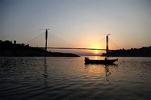
Atal Setu bridge on Ravi river
-

Dream park and canal
-

Dream park
-
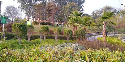
K.K. Birla Garden, Kathua


See also
 In Spanish: Kathua para niños
