Kathua district facts for kids
Quick facts for kids
Kathua district
|
|
|---|---|
|
District of Jammu and Kashmir administered by India
|
|

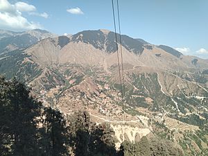
Mountainous areas in the east of Kathua
|
|

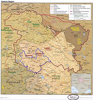
Kathua district is in the Jammu division (shown with neon blue boundary) of Indian-administered Jammu and Kashmir (shaded in tan in the disputed Kashmir region
|
|
| Administering country | India |
| Union territory | Jammu and Kashmir |
| Division | Jammu Division |
| Parliamentary Constituency | Udhampur-Doda-Kathua Constituency |
| District Headquarter | Kathua |
| Tehsils | Bani, Basholi, Billawar, Hiranagar, Kathua, Nagri-Parole, Marheen, Dinga Amb, Mahanpur, Lohai Malhar, Ramkote. |
| Area | |
| • Total | 2,502 km2 (966 sq mi) |
| • Urban | 43.16 km2 (16.66 sq mi) |
| • Rural | 2,458.84 km2 (949.36 sq mi) |
| Population
(2011)
|
|
| • Total | 616,435 |
| • Density | 246.38/km2 (638.11/sq mi) |
| • Urban | 89,713 |
| • Rural | 526,722 |
| Demographics | |
| • Literacy | 73.09% |
| • Sex ratio | 890 |
| Time zone | UTC+05:30 (IST) |
| Vehicle registration | JK-08 |
| Major highways | NH 44(Pathankot-Jammu), Bhaderwah-Basoli Highway, Border Road(Kathua-Bishnah). |
| Average annual precipitation | 921cm ( Annual-Billawar) mm |
| Website | https://kathua.nic.in/ |
Kathua district is an area in Jammu and Kashmir, which is part of India. It's located in the Jammu division of the Kashmir region.
The district has many different types of land. You'll find rich farms near the border with Punjab. There are also flat areas that lead up to the Himalaya mountains. In the east, you'll see the mountainous Pahari region.
Kathua district is divided into 8 main areas called blocks. These are Bani, Barnoti, Basholi, Billawar, Duggan, Ghagwal, Hiranagar, Kathua, and Lohai Malhar. The district has about 512 villages.
The main language spoken in Kathua is Dogri. In the mountains to the east, people often speak Pahari languages. For school, students learn in English, Hindi, and Urdu.
Contents
History of Kathua
A long time ago, about 2,000 years ago, a person named Jodh Singh from the Andotra family moved to Kathua. His three sons later started three small villages: Taraf Tajwal, Taraf Manjali, and Taraf Bhajwal. Their families are now known as the Tajwalia, Bhajwalia, and Khanwalia Rajputs.
Before 1921, Kathua district was called the Jasrota district. Between 1921 and 1931, the main office of the district moved to Kathua. The size of the district stayed the same.
Ancient Greek historians wrote about this area. They mentioned two strong groups, Abhisara and Kathaioi, when Alexander the Great came to India. The Kathaioi were a brave group living near the Ravi River. Their land matches where Kathua is today. The Greeks said the Kathaioi people were very courageous and fought hard against Alexander's army.
Many local stories say that the Pandavas (famous characters from the Mahabharata epic) visited Kathua. It's also believed that Lord Krishna came here to get back a special jewel called the Syamantaka Mani.
Because Kathua is close to the border with Pakistan, the Indian Army has had a strong presence here for a long time. The army helped keep the area safe during times of trouble. There were some challenges to peace in the region, especially from the late 1980s. The army worked to protect people and government buildings. By 2008, the situation became much calmer.
Basohli Paintings
Basohli, a town in Kathua district, is very famous for its unique paintings. These paintings are known for being strong, bold, and full of imagination. They use bright, primary colors and have a special way of showing faces.
This style of painting became popular in the 1600s and early 1700s. It started in Basohli and then spread to other nearby areas in the Western Himalayas. These places included Mankot, Nurpur, Kulu, Mandi, Suket, Bilaspur, Nalagarh, Chamba, Guler, and Kangra.
The first time Basohli painting was officially mentioned was in a report from the Archaeological Survey of India in 1921.
How Kathua is Governed
Kathua district is divided into four main parts: Bani, Basohli, Billawar/Badnota, and Hiranagar. These parts are then split into 11 smaller areas called tehsils:
- Kathua
- Hiranagar
- Billawar
- Basohli
- Bani
- Nagri
- Marheen
- Dinga Amb
- Mahanpur
- Lohai Malhar
- Ramkote
Politics
Kathua District has five areas that elect representatives to the assembly. These are Bani, Basohli, Kathua, Billawar, and Hiranagar (which is a special reserved area for Scheduled Castes).
People of Kathua (Demographics)
| Religion in Kathua district (2011) | ||||
|---|---|---|---|---|
| Religion | Percent | |||
| Hinduism | 87.61% | |||
| Islam | 10.42% | |||
| Sikhism | 1.55% | |||
| Other or not stated | 0.42% | |||
| Sex Ratio in Kathua District in 2011 Census. (no. females per 1,000 males) |
||||
|---|---|---|---|---|
| Religion (and population) | Sex Ratio | |||
| Hindu (pop 540,063) | 890 | |||
| Muslim (pop 64,234) | 904 | |||
| Sikh (pop 9,551) | 809 | |||
| Other (pop 2,587) | 873 | |||
| Total (pop 616,435) | 890 | |||
According to the 2011 census, Kathua district had a population of 616,435 people. This number is similar to the population of the country Solomon Islands or the US state of Vermont.
The district ranks 521st in population out of all 640 districts in India. Between 2001 and 2011, the population grew by about 20.53%.
In Kathua, there are 890 females for every 1000 males. The literacy rate (meaning how many people can read and write) is 73.09%. About 22.9% of the population belongs to Scheduled Castes, and 8.6% belong to Scheduled Tribes.
In 2011, most people (81.92%) in Kathua district spoke Dogri as their first language. Other languages spoken include Pahari (6.94%), Gojri (3.50%), Kashmiri (2.01%), Punjabi (1.86%), and Hindi (1.03%).
See also
 In Spanish: Distrito de Kathua para niños
- Jasrota
- Jasrotia
 | George Robert Carruthers |
 | Patricia Bath |
 | Jan Ernst Matzeliger |
 | Alexander Miles |

