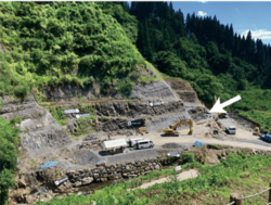
Katsuyama, Fukui facts for kids
Quick facts for kids
Katsuyama
勝山市
|
|||||||||||
|---|---|---|---|---|---|---|---|---|---|---|---|
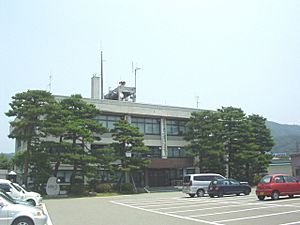
Katsuyama City Hall
|
|||||||||||
|
|||||||||||
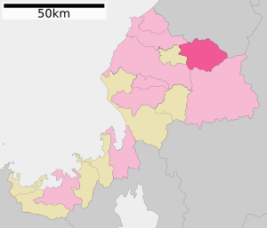
Location of Katsuyama in Fukui Prefecture
|
|||||||||||
| Country | Japan | ||||||||||
| Region | Chūbu (Hokuriku) | ||||||||||
| Prefecture | Fukui | ||||||||||
| Town settled | April 1, 1889 | ||||||||||
| City settled | September 1, 1954 | ||||||||||
| Area | |||||||||||
| • Total | 253.88 km2 (98.02 sq mi) | ||||||||||
| Population
(May 2018)
|
|||||||||||
| • Total | 23,527 | ||||||||||
| • Density | 92.670/km2 (240.014/sq mi) | ||||||||||
| Time zone | UTC+9 (Japan Standard Time) | ||||||||||
| Phone number | 0779-88-1111 | ||||||||||
| Address | 1-1-1 Motomachi, Katsuyama-shi, Fukui-ken 911-8501 | ||||||||||
| Climate | Cfa | ||||||||||
|
|||||||||||
Katsuyama (勝山市, Katsuyama-shi) is a city in Fukui Prefecture, Japan. As of May 2018, about 23,527 people lived there in 7,973 homes. The city covers an area of 253.88 square kilometers (98.02 sq mi). This means there are about 93 people per square kilometer. In 2007, Katsuyama was ranked as the ninth-best city for health and cleanliness around the world.
Contents
Exploring Katsuyama's Location
Katsuyama is in the northern part of Fukui Prefecture. It sits in a basin, which is like a bowl surrounded by mountains. To the north, it shares a border with Ishikawa Prefecture. The Kuzuryū River flows through some parts of the city. A portion of Katsuyama is also inside Hakusan National Park, a beautiful natural area.
Nearby Cities and Towns
Katsuyama is close to several other cities and towns. These are its neighbors:
Katsuyama's Weather and Climate
Katsuyama has a humid climate. This means it has warm, wet summers and cold winters with a lot of snow. The average temperature each year is about 13.3°C (55.9°F). July is usually the wettest month. The hottest month is August, with temperatures around 26.0°C (78.8°F). January is the coldest month, with temperatures around 1.1°C (34.0°F).
| Climate data for Katsuyama (1993−2020 normals, extremes 1993−present) | |||||||||||||
|---|---|---|---|---|---|---|---|---|---|---|---|---|---|
| Month | Jan | Feb | Mar | Apr | May | Jun | Jul | Aug | Sep | Oct | Nov | Dec | Year |
| Record high °C (°F) | 16.2 (61.2) |
17.3 (63.1) |
22.6 (72.7) |
29.4 (84.9) |
33.8 (92.8) |
34.7 (94.5) |
36.7 (98.1) |
36.8 (98.2) |
35.5 (95.9) |
29.7 (85.5) |
25.0 (77.0) |
22.0 (71.6) |
36.8 (98.2) |
| Mean daily maximum °C (°F) | 4.6 (40.3) |
5.7 (42.3) |
10.5 (50.9) |
17.1 (62.8) |
22.5 (72.5) |
25.7 (78.3) |
29.3 (84.7) |
31.0 (87.8) |
26.8 (80.2) |
21.1 (70.0) |
14.6 (58.3) |
7.7 (45.9) |
18.1 (64.5) |
| Daily mean °C (°F) | 1.1 (34.0) |
1.6 (34.9) |
5.3 (41.5) |
11.5 (52.7) |
17.1 (62.8) |
20.9 (69.6) |
24.7 (76.5) |
26.0 (78.8) |
21.8 (71.2) |
15.7 (60.3) |
9.7 (49.5) |
3.8 (38.8) |
13.3 (55.9) |
| Mean daily minimum °C (°F) | −1.7 (28.9) |
−1.9 (28.6) |
0.7 (33.3) |
6.1 (43.0) |
11.9 (53.4) |
16.8 (62.2) |
21.2 (70.2) |
22.0 (71.6) |
17.8 (64.0) |
11.4 (52.5) |
5.4 (41.7) |
0.6 (33.1) |
9.2 (48.5) |
| Record low °C (°F) | −9.1 (15.6) |
−9.8 (14.4) |
−6.9 (19.6) |
−2.9 (26.8) |
2.2 (36.0) |
8.9 (48.0) |
14.7 (58.5) |
14.0 (57.2) |
8.2 (46.8) |
1.9 (35.4) |
−1.7 (28.9) |
−8.0 (17.6) |
−9.8 (14.4) |
| Average precipitation mm (inches) | 224.5 (8.84) |
138.4 (5.45) |
154.2 (6.07) |
150.0 (5.91) |
159.7 (6.29) |
180.0 (7.09) |
291.4 (11.47) |
195.6 (7.70) |
195.0 (7.68) |
148.4 (5.84) |
180.0 (7.09) |
260.2 (10.24) |
2,281.5 (89.82) |
| Average precipitation days (≥ 1.0 mm) | 21.1 | 16.2 | 15.6 | 12.4 | 11.6 | 11.7 | 13.7 | 10.0 | 12.2 | 11.8 | 14.9 | 21.3 | 172.5 |
| Mean monthly sunshine hours | 67.1 | 89.3 | 125.0 | 163.8 | 185.5 | 142.2 | 141.8 | 191.2 | 141.1 | 149.1 | 114.9 | 74.6 | 1,585.6 |
| Source: Japan Meteorological Agency | |||||||||||||
Population Trends in Katsuyama
The number of people living in Katsuyama has been going down over the last 50 years. This is shown in the population data from Japanese census records.
| Historical population | ||
|---|---|---|
| Year | Pop. | ±% |
| 1970 | 32,691 | — |
| 1980 | 30,852 | −5.6% |
| 1990 | 29,805 | −3.4% |
| 2000 | 28,143 | −5.6% |
| 2010 | 25,466 | −9.5% |
| 2020 | 22,150 | −13.0% |
A Look at Katsuyama's Past
Katsuyama was once part of an old area called Echizen Province. During the Edo period (a time in Japanese history), this area was split into different parts controlled by various lords. After the Meiji Restoration (a big change in Japan's government), Katsuyama became part of Ōno District in Fukui Prefecture.
The town of Katsuyama was officially created on April 1, 1889. It grew by joining with the village of Inose in 1931. Later, on September 1, 1954, Katsuyama merged with several other villages. These villages were Arado, Muraoka, Kitago, Kitadani, Shikadani, Osoha, Heisen-ji, and Nomuki. This merger formed the city of Katsuyama as we know it today.
Katsuyama's Economy
The main way people in Katsuyama make a living is through farming. The city's economy relies mostly on agriculture.
Schools and Learning in Katsuyama
Katsuyama has many schools for young people.
- There are nine public elementary schools run by the city government.
- The city also has three public middle schools.
- There is one private school that combines elementary and middle school levels.
- For older students, there is one public high school. This high school is managed by the Fukui Prefectural Board of Education.
- The prefecture also runs a special education school in Katsuyama.
Getting Around Katsuyama
Train Travel
Katsuyama has a train line that helps people travel around.
Major Roads
Highways also connect Katsuyama to other places.
Friends Around the World
Katsuyama has a special friendship with a city in the United States.
 Aspen, Colorado, United States, is a friendship city.
Fun Places to Visit in Katsuyama
Katsuyama has some exciting places that visitors enjoy.
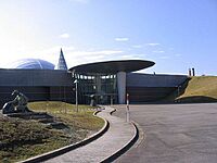
- Fukui Prefectural Dinosaur Museum: This museum is famous for its dinosaur fossils and exhibits.
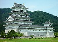
- Katsuyama Castle: A historic castle that tells stories of the past.
- Heisenji Hakusan Jinja: A beautiful shrine with a long history.
Famous People from Katsuyama
Some well-known individuals come from Katsuyama:
- Unshō Ishizuka, a voice actor.
- Akane Yamaguchi, a Japanese badminton player.
- Genichiro Tenryu, a former professional wrestler from Japan.
See also
 In Spanish: Katsuyama (Fukui) para niños
 | Isaac Myers |
 | D. Hamilton Jackson |
 | A. Philip Randolph |


