Kaga, Ishikawa facts for kids
Quick facts for kids
Kaga
加賀市
|
|||||||||||||
|---|---|---|---|---|---|---|---|---|---|---|---|---|---|

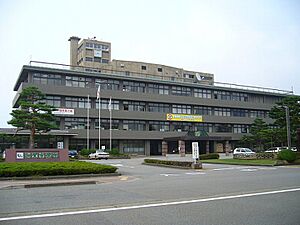
Kaga City Hall
|
|||||||||||||
|
|||||||||||||

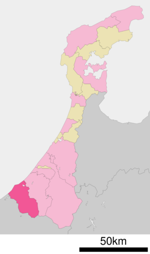
Location of Kaga in Ishikawa Prefecture
|
|||||||||||||
| Country | Japan | ||||||||||||
| Region | Chūbu (Hokuriku) | ||||||||||||
| Prefecture | Ishikawa Prefecture | ||||||||||||
| Area | |||||||||||||
| • Total | 305.87 km2 (118.10 sq mi) | ||||||||||||
| Population
(March 1, 2018)
|
|||||||||||||
| • Total | 67,793 | ||||||||||||
| • Density | 221.640/km2 (574.045/sq mi) | ||||||||||||
| Time zone | UTC+9 (Japan Standard Time) | ||||||||||||
| Phone number | 0761-72-1111 | ||||||||||||
| Address | 2–41 Minami-chō, Daishōji, Kaga-shi, Ishikawa-ken 922-8622 |
||||||||||||
| Climate | Cfa | ||||||||||||
|
|||||||||||||
Kaga (加賀市, Kaga-shi) is a city in Japan. It is located in the southwestern part of Ishikawa Prefecture. As of March 1, 2018, about 67,793 people lived there. The city covers an area of 305.87 square kilometers.
Contents
Geography of Kaga
Kaga is in the very southwest of Ishikawa Prefecture, Japan. It is part of the Hokuriku region. The city is next to the Sea of Japan on its west side. To the south, it borders Fukui Prefecture. Some parts of Kaga's coast are inside the Echizen-Kaga Kaigan Quasi-National Park.
Nearby Cities and Towns
Kaga shares borders with several other places:
Climate in Kaga
Kaga has a humid continental climate. This means it has mild summers and cold winters. There is often heavy snowfall in winter. The average temperature in Kaga is 14.2 degrees Celsius. September is usually the wettest month. The warmest month is August, with temperatures around 26.8 degrees Celsius. January is the coldest month, with temperatures around 2.8 degrees Celsius.
| Climate data for Kaga (1991−2020 normals, extremes 1978−present) | |||||||||||||
|---|---|---|---|---|---|---|---|---|---|---|---|---|---|
| Month | Jan | Feb | Mar | Apr | May | Jun | Jul | Aug | Sep | Oct | Nov | Dec | Year |
| Record high °C (°F) | 18.2 (64.8) |
19.7 (67.5) |
25.9 (78.6) |
29.8 (85.6) |
33.9 (93.0) |
34.1 (93.4) |
37.4 (99.3) |
37.6 (99.7) |
35.6 (96.1) |
30.4 (86.7) |
25.6 (78.1) |
23.1 (73.6) |
37.4 (99.3) |
| Mean daily maximum °C (°F) | 5.5 (41.9) |
6.4 (43.5) |
10.9 (51.6) |
17.4 (63.3) |
22.5 (72.5) |
25.5 (77.9) |
29.2 (84.6) |
30.8 (87.4) |
26.4 (79.5) |
20.9 (69.6) |
15.0 (59.0) |
8.7 (47.7) |
18.3 (64.9) |
| Daily mean °C (°F) | 1.9 (35.4) |
2.2 (36.0) |
5.5 (41.9) |
11.3 (52.3) |
16.4 (61.5) |
20.2 (68.4) |
24.3 (75.7) |
25.4 (77.7) |
21.2 (70.2) |
15.4 (59.7) |
9.8 (49.6) |
4.6 (40.3) |
13.2 (55.7) |
| Mean daily minimum °C (°F) | −0.7 (30.7) |
−1.1 (30.0) |
1.0 (33.8) |
5.8 (42.4) |
10.9 (51.6) |
15.9 (60.6) |
20.6 (69.1) |
21.4 (70.5) |
17.4 (63.3) |
11.4 (52.5) |
5.8 (42.4) |
1.4 (34.5) |
9.2 (48.4) |
| Record low °C (°F) | −8.0 (17.6) |
−7.7 (18.1) |
−4.8 (23.4) |
−2.3 (27.9) |
1.9 (35.4) |
7.4 (45.3) |
13.3 (55.9) |
13.6 (56.5) |
7.9 (46.2) |
2.0 (35.6) |
−1.0 (30.2) |
−5.7 (21.7) |
−8.0 (17.6) |
| Average precipitation mm (inches) | 375.3 (14.78) |
223.2 (8.79) |
221.0 (8.70) |
177.9 (7.00) |
179.3 (7.06) |
202.5 (7.97) |
296.3 (11.67) |
214.6 (8.45) |
275.8 (10.86) |
222.2 (8.75) |
286.2 (11.27) |
411.3 (16.19) |
3,085.5 (121.48) |
| Average snowfall cm (inches) | 192 (76) |
159 (63) |
48 (19) |
1 (0.4) |
0 (0) |
0 (0) |
0 (0) |
0 (0) |
0 (0) |
0 (0) |
0 (0) |
68 (27) |
467 (184) |
| Average rainy days (≥ 1.0 mm) | 24.5 | 19.7 | 17.3 | 12.9 | 11.8 | 11.9 | 13.7 | 10.6 | 12.9 | 13.8 | 17.6 | 23.8 | 190.5 |
| Average snowy days (≥ 3 cm) | 17.1 | 15.7 | 5.3 | 0.2 | 0 | 0 | 0 | 0 | 0 | 0 | 0.1 | 6.8 | 45.2 |
| Mean monthly sunshine hours | 52.4 | 74.7 | 125.9 | 177.5 | 199.7 | 139.8 | 152.2 | 196.8 | 133.6 | 134.1 | 101.7 | 58.8 | 1,547.1 |
| Source: Japan Meteorological Agency | |||||||||||||
Population Trends in Kaga
The number of people living in Kaga grew until around 1990. Since then, the population has slowly gone down.
| Historical population | ||
|---|---|---|
| Year | Pop. | ±% |
| 1970 | 69,664 | — |
| 1980 | 77,335 | +11.0% |
| 1990 | 80,714 | +4.4% |
| 2000 | 79,653 | −1.3% |
| 2010 | 71,887 | −9.7% |
| 2020 | 63,220 | −12.1% |
History of Kaga
The area where Kaga is located today was once part of an old region called Kaga Province. During the Edo period, this area was part of the Daishōji Domain. This was a special area ruled by a local lord under the Tokugawa shogunate.
After the Meiji Restoration, a big change in Japan's government, the area became part of Enuma District. The town of Daishōji was officially created on April 1, 1889. Later, on January 1, 1958, Daishōji joined with several other towns and villages to form the city of Kaga. The city grew even more on October 1, 2005, when it merged with the town of Yamanaka.
Economy and Industries
Kaga is known for its traditional crafts and tourism.
- Kutani ware is a famous type of ceramic pottery made in Kaga.
- Kaga habutae is a special kind of silk fabric also produced here.
- The city is also a popular place for tourists. Many people visit its beautiful temples and relaxing hot-springs.
Education in Kaga
Kaga has many schools for young people. The city government runs 21 public elementary schools and seven middle schools. The Ishikawa Prefectural Board of Education operates four public high schools. There is also a special education school in the prefecture.
Transportation in Kaga
Getting around Kaga and to other cities is easy with its railway and highway systems.
Railway Services
The Hokuriku Shinkansen is the main train service in Kaga since March 16, 2024.
- Hokuriku Shinkansen
- Kagaonsen
- IR Ishikawa Railway
- Daishōji – Kagaonsen – Iburihashi
Major Highways
- Hokuriku Expressway
- National Routes:
 National Route 8
 National Route 305
 National Route 364
 National Route 365
Popular Local Attractions
Kaga is home to famous hot springs that people love to visit:
- Yamanaka Onsen
- Yamashiro Onsen
Sister Cities
Kaga has special friendship agreements with cities in other countries:
 Birštonas, Lithuania (friendship city)
 Dundas, Ontario, Canada (since 1968)
 Tainan, Taiwan (friendship city)
Notable People from Kaga
Many interesting people have come from Kaga:
- Rokusaburo Michiba: A famous Japanese cuisine chef. He was known as the first "Iron Chef" on the TV show.
- Yamada Sōbi: An artist who works with metals.
- Shoji Tabuchi (1944–2023): A fiddler and entertainer, famous in Branson, Missouri.
- Masanobu Tsuji: An army officer and politician.
See also
 In Spanish: Kaga (Ishikawa) para niños
 | Aaron Henry |
 | T. R. M. Howard |
 | Jesse Jackson |


