Kawauchi, Fukushima facts for kids
Quick facts for kids
Kawauchi
川内村
|
|||||||||||||
|---|---|---|---|---|---|---|---|---|---|---|---|---|---|
 |
|||||||||||||
|
|||||||||||||

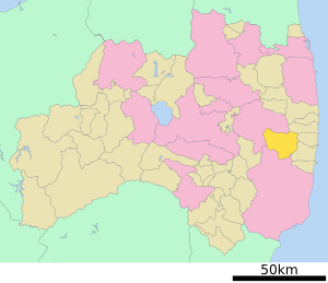
Location of Kawauchi in Fukushima Prefecture
|
|||||||||||||
| Country | Japan | ||||||||||||
| Region | Tōhoku | ||||||||||||
| Prefecture | Fukushima | ||||||||||||
| District | Futaba | ||||||||||||
| Area | |||||||||||||
| • Total | 197.35 km2 (76.20 sq mi) | ||||||||||||
| Population
(January 1, 2020)
|
|||||||||||||
| • Total | 1,861 | ||||||||||||
| • Density | 9.4299/km2 (24.423/sq mi) | ||||||||||||
| Time zone | UTC+9 (Japan Standard Time) | ||||||||||||
| Phone number | 0240-38-2111 | ||||||||||||
| Address | Kamikawauchi, Kawauchi-mura, Futaba-gun, Fukushima-ken 979-1292 | ||||||||||||
| Climate | Cfa | ||||||||||||
|
|||||||||||||
Kawauchi (pronounced Kah-wah-oo-chee) is a small village in Fukushima Prefecture, Japan. As of January 1, 2020, about 1,861 people lived there. The village covers an area of 197.35 square kilometers (about 76 square miles).
Kawauchi is located in the Futaba district. In 2011, the village had to be evacuated because of the Fukushima Daiichi nuclear disaster. However, by 2014, people were allowed to return, and most restrictions were lifted.
Contents
Geography of Kawauchi
Kawauchi is found in the Abukuma Plateau, which is a high, flat area in central Fukushima. The village sits at an average height of 400 to 500 meters (about 1,300 to 1,600 feet) above sea level.
Neighboring Towns and Cities
Kawauchi shares its borders with several other places in Fukushima Prefecture:
Kawauchi's Climate
Kawauchi has a humid continental climate. This means it has mild summers and cold winters. Winters often bring a lot of snow.
The average temperature in Kawauchi is about 10.3°C (50.5°F) each year. September is usually the wettest month. The warmest month is August, with temperatures around 22.5°C (72.5°F). January is the coldest, with temperatures around -0.7°C (30.7°F).
| Climate data for Kawauchi (1991−2020 normals, extremes 1976−present) | |||||||||||||
|---|---|---|---|---|---|---|---|---|---|---|---|---|---|
| Month | Jan | Feb | Mar | Apr | May | Jun | Jul | Aug | Sep | Oct | Nov | Dec | Year |
| Record high °C (°F) | 15.7 (60.3) |
20.1 (68.2) |
23.0 (73.4) |
29.7 (85.5) |
32.2 (90.0) |
34.1 (93.4) |
35.7 (96.3) |
36.5 (97.7) |
33.6 (92.5) |
28.2 (82.8) |
24.1 (75.4) |
20.3 (68.5) |
36.5 (97.7) |
| Mean daily maximum °C (°F) | 4.3 (39.7) |
5.2 (41.4) |
9.1 (48.4) |
15.2 (59.4) |
20.4 (68.7) |
23.1 (73.6) |
26.9 (80.4) |
27.9 (82.2) |
23.7 (74.7) |
18.2 (64.8) |
13.1 (55.6) |
7.3 (45.1) |
16.2 (61.2) |
| Daily mean °C (°F) | −0.5 (31.1) |
0.0 (32.0) |
3.3 (37.9) |
8.8 (47.8) |
14.0 (57.2) |
17.7 (63.9) |
21.7 (71.1) |
22.5 (72.5) |
18.6 (65.5) |
12.6 (54.7) |
6.9 (44.4) |
2.1 (35.8) |
10.6 (51.2) |
| Mean daily minimum °C (°F) | −5.3 (22.5) |
−5.1 (22.8) |
−2.1 (28.2) |
2.4 (36.3) |
7.8 (46.0) |
12.9 (55.2) |
17.5 (63.5) |
18.4 (65.1) |
14.2 (57.6) |
7.6 (45.7) |
1.2 (34.2) |
−2.7 (27.1) |
5.6 (42.0) |
| Record low °C (°F) | −17.7 (0.1) |
−18.4 (−1.1) |
−17.0 (1.4) |
−11.5 (11.3) |
−3.1 (26.4) |
1.4 (34.5) |
6.2 (43.2) |
6.2 (43.2) |
1.0 (33.8) |
−4.7 (23.5) |
−9.2 (15.4) |
−18.0 (−0.4) |
−18.4 (−1.1) |
| Average precipitation mm (inches) | 62.3 (2.45) |
47.4 (1.87) |
95.1 (3.74) |
122.4 (4.82) |
111.3 (4.38) |
141.2 (5.56) |
181.2 (7.13) |
171.8 (6.76) |
234.1 (9.22) |
181.0 (7.13) |
70.2 (2.76) |
48.3 (1.90) |
1,484.1 (58.43) |
| Average precipitation days (≥ 1.0 mm) | 5.9 | 5.9 | 9.1 | 9.5 | 10.4 | 12.3 | 13.8 | 11.2 | 12.1 | 9.9 | 7.0 | 6.3 | 113.4 |
| Mean monthly sunshine hours | 170.7 | 169.0 | 186.9 | 194.3 | 203.6 | 148.5 | 144.0 | 159.6 | 122.2 | 132.0 | 149.2 | 161.6 | 1,943.4 |
| Source: Japan Meteorological Agency | |||||||||||||
Population Changes in Kawauchi
Over the last 60 years, the number of people living in Kawauchi has slowly gone down. Today, the population is less than half of what it was 100 years ago.
| Historical population | ||
|---|---|---|
| Year | Pop. | ±% |
| 1920 | 5,573 | — |
| 1930 | 4,275 | −23.3% |
| 1940 | 4,540 | +6.2% |
| 1950 | 5,930 | +30.6% |
| 1960 | 5,966 | +0.6% |
| 1970 | 4,709 | −21.1% |
| 1980 | 4,132 | −12.3% |
| 1990 | 3,933 | −4.8% |
| 2000 | 3,384 | −14.0% |
| 2010 | 2,821 | −16.6% |
| 2020 | 2,044 | −27.5% |
History of Kawauchi
The area where Kawauchi is today was once part of a larger region called Mutsu Province. On April 1, 1889, after a big change in Japan called the Meiji restoration, Kawauchi officially became a village. This was when Japan started setting up its modern system of towns and villages.
Impact of the 2011 Fukushima Nuclear Disaster
Kawauchi was affected by the 2011 Tōhoku earthquake and tsunami. The village was also close to the Fukushima Daiichi nuclear power plant. Because of the nuclear accident, everyone in Kawauchi had to leave their homes by May 2011.
Some parts of the village were reopened in March 2012. By August 2014, the government allowed more people to return. By 2017, over 80% of the villagers had come back. However, many younger people did not return as quickly as older residents.
Scientists have checked the radiation levels in Kawauchi. In 2012, the average radiation exposure for residents was very low. Even so, some wild mushrooms collected between 2016 and 2019 still showed small amounts of radioactive cesium.
Kawauchi's Economy
In the past, Kawauchi's economy mainly depended on agriculture. This means most people worked in farming.
Education in Kawauchi
Before the 2011 disaster, Kawauchi had two high schools, one junior high school, two elementary schools, and a kindergarten. After the village was evacuated and then reopened, both high schools closed down.
Today, the village still has:
- One junior high school
- One elementary school
- One kindergarten
Transportation in Kawauchi
Train Services
Kawauchi does not have any train stations.
Bus Services
Buses serve Kawauchi, connecting the village to areas both east and west.
Major Roads
 National Route 399
See also
 In Spanish: Kawauchi (Fukushima) para niños
 | Kyle Baker |
 | Joseph Yoakum |
 | Laura Wheeler Waring |
 | Henry Ossawa Tanner |


