Kermit, West Virginia facts for kids
Quick facts for kids
Kermit, West Virginia
|
|
|---|---|
 |
|

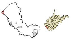
Location of Kermit in Mingo County, West Virginia.
|
|
| Country | |
| State | |
| County | Mingo |
| Area | |
| • Total | 0.39 sq mi (1.02 km2) |
| • Land | 0.39 sq mi (1.02 km2) |
| • Water | 0.00 sq mi (0.00 km2) |
| Elevation | 633 ft (193 m) |
| Population
(2010)
|
|
| • Total | 406 |
| • Estimate
(2019)
|
349 |
| • Density | 890.31/sq mi (343.71/km2) |
| Time zone | UTC-5 (Eastern (EST)) |
| • Summer (DST) | UTC-4 (EDT) |
| ZIP code |
25674
|
| Area code(s) | 304 |
| FIPS code | 54-43300 |
| GNIS feature ID | 1541162 |
| Website | https://local.wv.gov/kermit/Pages/default.aspx |
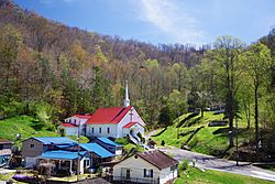
Kermit is a small town located in Mingo County, West Virginia, in the United States. In 2010, about 406 people lived there. Kermit sits right next to the Tug Fork river. Across the river is another town called Warfield, Kentucky. A railway line, the Norfolk Southern Railway's Kenova District, also runs through Kermit.
The area where Kermit is now was once known by other names. These included "Lower Burning Creek," "East Warfield," and "Warfield." The town got its current name, "Kermit," in 1906. This happened when a post office was opened there. The town was named after Kermit Roosevelt. He was the son of the 26th U.S. President, Theodore Roosevelt. Kermit officially became a town in 1909.
Geography of Kermit
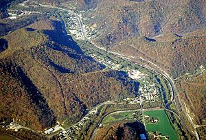
Kermit is in the northwestern part of Mingo County. It is mainly built on the flat land along the eastern side of the Tug Fork river. Many of the town's main buildings are in a valley. This valley is in the northeastern part of town, along Main Street and High Street.
A major road, U.S. Route 52, goes through Kermit. This road connects the town to Williamson in the south. It also links Kermit to Kenova in the north. There is a bridge that lets cars and people cross the Tug Fork river. This bridge connects Kermit to Kentucky Route 292 in Warfield. The Norfolk Southern railroad tracks run close to US-52.
The United States Census Bureau says that Kermit covers about 0.39 square miles (1.02 square kilometers). All of this area is land.
Kermit's Climate
The weather in Kermit has hot and humid summers. The winters are usually mild to cool. According to the Köppen Climate Classification system, Kermit has a humid subtropical climate. This type of climate is often shown as "Cfa" on climate maps.
People of Kermit
| Historical population | |||
|---|---|---|---|
| Census | Pop. | %± | |
| 1920 | 636 | — | |
| 1930 | 740 | 16.4% | |
| 1940 | 811 | 9.6% | |
| 1950 | 964 | 18.9% | |
| 1960 | 743 | −22.9% | |
| 1970 | 716 | −3.6% | |
| 1980 | 705 | −1.5% | |
| 1990 | 342 | −51.5% | |
| 2000 | 209 | −38.9% | |
| 2010 | 406 | 94.3% | |
| 2019 (est.) | 349 | −14.0% | |
| U.S. Decennial Census | |||
The United States Census counts how many people live in an area. It also gathers information about them.
2010 Census Information
In 2010, the census showed that 406 people lived in Kermit. There were 152 households and 110 families. A household is a group of people living together. A family is a group of related people living together.
The town had about 1041 people per square mile. There were 164 housing units, which are places where people can live.
Most of the people in Kermit were White (98.8%). A small number were African American (0.2%). Some were Native American (0.2%). A few were Pacific Islander (0.2%) or from two or more races (0.5%). About 1.2% of the population was Hispanic or Latino.
In 40.8% of households, there were children under 18 years old. About 52.0% of households were married couples living together. Some households had a female head with no husband (13.8%). Others had a male head with no wife (6.6%). About 27.6% of households were not families.
The average age of people in Kermit was 37.5 years. About 26.1% of residents were under 18. About 8.2% were between 18 and 24. People aged 25 to 44 made up 28.4% of the population. Those aged 45 to 64 were 24.7%. About 12.8% of residents were 65 or older. The town had slightly more males (52.5%) than females (47.5%).
See also
 In Spanish: Kermit (Virginia Occidental) para niños
 | Leon Lynch |
 | Milton P. Webster |
 | Ferdinand Smith |


