Keystone, West Virginia facts for kids
Quick facts for kids
Keystone, West Virginia
|
|
|---|---|

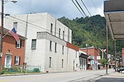
U.S. Route 52 in the city's southwest
|
|

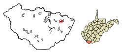
Location of Keystone in McDowell County, West Virginia.
|
|
| Country | United States |
| State | West Virginia |
| County | McDowell |
| Area | |
| • Total | 0.32 sq mi (0.84 km2) |
| • Land | 0.32 sq mi (0.84 km2) |
| • Water | 0.00 sq mi (0.00 km2) |
| Elevation | 1,631 ft (497 m) |
| Population
(2010)
|
|
| • Total | 282 |
| • Estimate
(2019)
|
223 |
| • Density | 688.27/sq mi (265.98/km2) |
| Time zone | UTC-5 (Eastern (EST)) |
| • Summer (DST) | UTC-4 (EDT) |
| ZIP code |
24852
|
| Area code(s) | 304 |
| FIPS code | 54-43516 |
| GNIS feature ID | 1554871 |
| Website | https://local.wv.gov/keystone/Pages/default.aspx |
Keystone is a small city in McDowell County, West Virginia, United States. In 2020, about 176 people lived there. Keystone is special because it's one of the few towns in West Virginia where most residents are African American. About 65% of the people living there are Black.
A long time ago, a local newspaper editor named Matthew Thomas Whittico called the area the "Free State of McDowell." This was because Keystone was a good place for African Americans to move to in the late 1800s and early 1900s. It had a unique mix of politics, community, and jobs that made it welcoming.
Contents
History of Keystone
Keystone was started in 1892 by a company called Keystone Coal & Coke Company. The city officially became a town, or was incorporated, in 1909. This decision was made by the Circuit Court of McDowell County. The city got its name from the coal and coke company that operated there. Before it was called Keystone, the city was known as Cassville.
The Miners' Strike of 1895
On May 1, 1895, about 15,000 union miners gathered in Keystone. Most of these miners were Black. They armed themselves and planned to march into Virginia. Their goal was to convince miners in a nearby Virginia mine to join their union. A union is a group of workers who join together to protect their rights and improve their working conditions.
The governor of Virginia, Charles Triplett O'Ferrall, sent soldiers to the Virginia border. However, West Virginia's Governor William A. MacCorkle did not send his own soldiers to help stop the march.
This event happened because the N&W Railroad had lowered the price they would pay for coal shipped to ports. Because of this, coal mine owners cut their workers' wages by 20%. The owners then encouraged their miners to go on strike. By the end of April that year, most mines in West Virginia had stopped working. But a large mine across the state line in Virginia kept operating.
The strike ended by late August. The UMWA was a new union at the time. It could not afford to support such a large strike for very long. In the end, most mines started working again. Many of them hired new workers, called strikebreakers, to replace the striking miners.
Geography of Keystone
According to the United States Census Bureau, Keystone covers a total area of about 0.32 square miles (0.84 square kilometers). All of this area is land.
The city is also home to a railway station. This station is part of the Norfolk Southern Railway network, which used to be the Norfolk and Western railway.
Population and People
| Historical population | |||
|---|---|---|---|
| Census | Pop. | %± | |
| 1900 | 1,088 | — | |
| 1910 | 2,047 | 88.1% | |
| 1920 | 1,839 | −10.2% | |
| 1930 | 1,897 | 3.2% | |
| 1940 | 2,942 | 55.1% | |
| 1950 | 2,594 | −11.8% | |
| 1960 | 1,457 | −43.8% | |
| 1970 | 1,008 | −30.8% | |
| 1980 | 902 | −10.5% | |
| 1990 | 627 | −30.5% | |
| 2000 | 453 | −27.8% | |
| 2010 | 282 | −37.7% | |
| 2020 | 176 | −37.6% | |
| U.S. Decennial Census 2015 Estimate |
|||
Keystone's Population in 2020
The United States Census counts how many people live in an area and gathers information about them. In 2020, Keystone had a population of 176 people.
Here's a look at the different groups of people living in Keystone in 2020:
| Race / Ethnicity (NH = Non-Hispanic) | Pop 2010 | Pop 2020 | % 2010 | % 2020 |
|---|---|---|---|---|
| White alone (NH) | 96 | 62 | 34.04% | 35.23% |
| Black or African American alone (NH) | 183 | 101 | 64.89% | 57.39% |
| Native American or Alaska Native alone (NH) | 0 | 0 | 0.00% | 0.00% |
| Asian alone (NH) | 1 | 1 | 0.35% | 0.57% |
| Native Hawaiian or Pacific Islander alone (NH) | 0 | 0 | 0.00% | 0.00% |
| Other race alone (NH) | 0 | 1 | 0.00% | 0.57% |
| Mixed race or Multiracial (NH) | 0 | 10 | 0.00% | 5.68% |
| Hispanic or Latino (any race) | 2 | 1 | 0.71% | 0.57% |
| Total | 282 | 176 | 100.00% | 100.00% |
Keystone's Population in 2010
In 2010, the city had 282 people living in 122 households. The population density was about 881 people per square mile.
About 34.4% of the people were White, and 65.2% were African American. A small number, 0.4%, were Asian. About 0.7% of the population identified as Hispanic or Latino.
The average age of people in Keystone was 38 years old. About 23.4% of residents were under 18. About 12.4% were 65 years or older. The city had more females (58.5%) than males (41.5%).
Notable Residents
- Stewart A. Calhoun, a lawyer and state legislator
See also
 In Spanish: Keystone (Virginia Occidental) para niños
 | Roy Wilkins |
 | John Lewis |
 | Linda Carol Brown |

